
Steve25
-
Posts
726 -
Joined
-
Last visited
About Steve25

- Birthday 07/18/1994
-
 Since 2016 in February, BWI has had less than an inch four times. Between 1-3 inches three times. Then the others were 3.8, 5, and 6.1. Just for good measure since 2016 in March, BWI has went 2.3, 2.5, 6.7, 2.7, 0, 0, 0.4, trace, trace, trace. So yeah since 2016 our February and March finishes to winter have been atrocious.
 -
When Chuck said enjoy your winter until the 9th, and then close the door, we should’ve listened
-
I imagine back in those days they weren’t really expecting any kind of accurate details 7+ days in advance.
-
Two show cutters, one shows nothing at all(GFS) and the other shows suppressed.
-
Chuck said screw your thoughts and analysis, and double screw that groundhog, it’s OVER!
-
Tom Tasselmyer tweeted that BWI will break into the top 10 of consecutive days with at least 1 inch of snow on the ground tomorrow with 12 days. I’m curious exactly how much is currently left on the ground where they record that measurement and how long they can go. I’d imagine it’s not out of the question they can make it until next Monday with the cold air settling back in place. That would put them at 16 days.
-
Seems like the general trend across guidance today is the push back of the cold air next week quicker and stronger against that ridging.
-
Yeah, starting to see the dreaded “Pattern should be much more favorable by March” remarks.
-
Punting to March? Yikes
-
Just to clarify, we are not concerned about fighting a significant warmup after next weekend? Trying to not put much stock into the 0z suite tonight
-
I didn’t realize just how bad February has been in Baltimore, honestly going all the way back to 2011. February is historically BWIs snowiest month, averaging 7.5 inches. 2014 and 2015 were good. Both saw just under 15 inches in February. Aside from that, BWI has been below average every other February since 2011. 13 out of 15 years. 10 out of those 13 years have seen less than 3 inches. In the 141 years of record keeping for BWI, they’ve recorded double digit snowfall in February 37 times. That comes out to about once every 4 years on average. It’s been 10 consecutive years without a double digit February. Most of them have been LOW in the single digits as well. I’d say the WDI is very high!
-
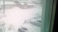
14 in downtown Bmore.
-
It wasn’t far off from a couple systems swinging by, though. For whatever that’s worth. On another note, the regular Euro continues to be pretty unenthusiastic about any potential system next week
-
It is. I tried walking on some of the untouched, grass covered areas today and it actually caught me off guard how slick it was.
-
Love the idea of this potential getting juiced up a bit but can we not do 1 inch in Baltimore while just to west everyone gets 6-10


