

miamarsden8
-
Posts
113 -
Joined
-
Last visited
Content Type
Profiles
Blogs
Forums
American Weather
Media Demo
Store
Gallery
Posts posted by miamarsden8
-
-
Updated blizzard warning from the NWS I missed...and lo and behold. Remember how I called 6-10 inches? They get it now.
URGENT - WINTER WEATHER MESSAGE
National Weather Service Quad Cities IA IL
530 PM CST Sun Nov 25 2018

...Major Winter Storm Today and Tonight with Blizzard Conditions
in Portions of the Area...

ILZ034-035-260730-
/O.CON.KDVN.BZ.W.0001.000000T0000Z-181126T1200Z/
Hancock-McDonough-
Including the cities of Carthage and Macomb
530 PM CST Sun Nov 25 2018

...BLIZZARD WARNING REMAINS IN EFFECT UNTIL 6 AM CST MONDAY...

* WHAT...Blizzard conditions. Additional snow accumulations of 4
  to 7 inches. Storm total 6 to 10 inches. Winds gusting as high
  as 45 mph.

* WHERE...Hancock and McDonough Counties.

* WHEN...Until 6 AM CST Monday.

* ADDITIONAL DETAILS...Travel will be very difficult and
  dangerous. Areas of blowing snow could significantly reduce
  visibility. Gusty winds could bring down tree branches.

PRECAUTIONARY/PREPAREDNESS ACTIONS...

A Blizzard Warning means severe winter weather conditions are
expected or occurring. Falling and blowing snow with strong winds
and poor visibilities are likely. This will lead to whiteout
conditions, making travel extremely dangerous. Do not travel. If
you must travel, have a winter survival kit with you. If you get
stranded, stay with your vehicle.

Additional information can be found at www.weather.gov/quadcities
-
1 minute ago, janetjanet998 said:
all wasted so far
 although mostly snow now on the NW side
0633 PM HEAVY RAIN PEORIA 40.74N 89.61W
11/25/2018 M1.03 INCH PEORIA IL OFFICIAL NWS OBS
RAINFALL IN THE LAST 12 HOURSCome on, come a bit further to the south!!!
-
6 minutes ago, Powerball said:

Galesburg, eh? Nice to see ya, neighbor. I'm in Macomb so yeah! Don't travel down here, obviously.
-
They've shut down Highway 67 in Good Hope due to whiteout conditions, which means no one can enter Macomb easily. Thank god.
-
Just now, SchaumburgStormer said:
Major 4 vehicle head on accident just outside of town.
Jesus...that's really awful to hear ): why are people still trying to travel out there...I don't understand.
-
Just now, Hoosier said:
HRRR suggests relatively little movement of the rain/snow line in Cook county over the next couple hours.
It appears the rain/snow line is actually a bit west of where the model has it at 00z, at least in the Chicago area.

But it's also about 10 miles south of where any NWS people had predicted it over here, and I'm so, so happy about it.
-
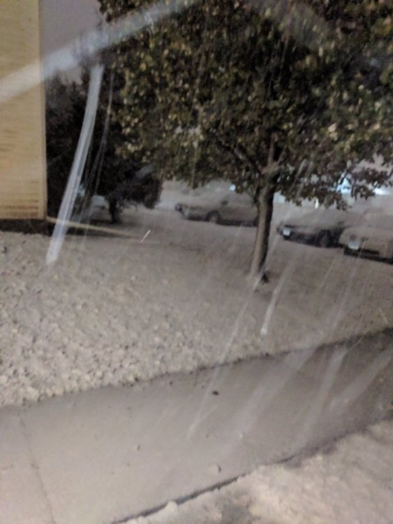
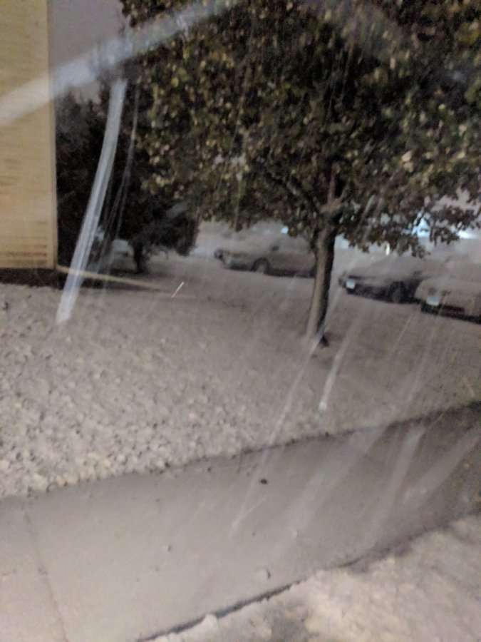
A picture from the first hour of full on snow...
-
 1
1
-
-
1 minute ago, Chinook said:
Muscatine wind gusts are much higher than surrounding stations. Equipment problem?
I don't know. We just hit a 2nd 46 mph gust here.
-
Just now, tim123 said:
Anyone got 18z euro
I'm refreshing the page waiting for it to come up, will post as soon as I see it if someone doesn't beat me to the punch.
-
The fact that the HRRR has us right between a band of either getting 11 inches or 5 inches is killing my anxiety. What a day.
-
2 minutes ago, janetjanet998 said:
I still have this concern ...if fact the new HRRR has cut snow totals for the city of peoria
also I believe there is a slug of warm air aloft surging north over Ne IL at this time..
the bright returns on the radar are edging north
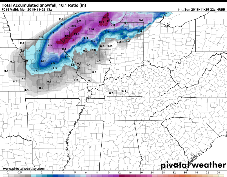
For reference, here's the new HRRR. It actually gives Macomb a bit more snow.
-
It's very wet and windy now, snow is a very wet snow. Got a grad school cohort member up on the WI-IL border and basically is showing us footage of the disaster up there. It's gonna get pretty close to that now. The fact that the snow-rain border seems to have stalled a bit to the southeast of us, I think the NWS would be well served to extend the amount here down to where the stalling is occurring.
Edit: Observations got a gust at 46.
-
Just now, CoalCityWxMan said:
Get ready to get dumped on
Good luck guys! Gg Euro on the placement. Now...will it be accurate in amount?
-
1 minute ago, Kaner88 said:
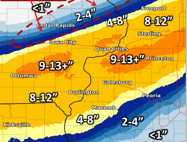
Updated LOT snowfall outlook now with two spots of >12" totals:

This is what ours is saying and I still think it's off a couple inches in the Macomb area since we're having snow pop the ground now. 7 inches would be okay, but I feel 8-10 is within range.
-
1 minute ago, Hoosier said:
Actually snowing in Quincy right now.
Yeah, I just checked out the radar, I can see that...I'm a broadcaster and we look at areas from Quincy up to Peoria and Burlington, so like, I'm really looking forward to tomorrow's headlines. This is going to be so much fun for me...a dream come true, really.
-
Let's just take a second and look at the line between blizzard and tornado warning. Incredible.
-
9
-
-
1 minute ago, CoalCityWxMan said:
Tornado warning associated with this system in the St. Louis area. Quite the system
....this is incredible. I'm so happy I've gotten the chance to watch this.
So I just went outside...it's like a 70, 75 percent snow, 25-30 percent rain mix out there. And since it's changing now, that might be worth another inch of snow, to be honest...
-
Just now, Chinook said:
Macomb IL has 32 degrees and rain. Shouldn't that be reported as freezing rain?
https://w1.weather.gov/data/obhistory/KMQB.html
You'd think, but this is Macomb.-
 1
1
-
-
Last look at the observations had 33 with light rain and gusts up to 38.
-
6 minutes ago, janetjanet998 said:
its cool to watch the rain/snow line surge SE with the convective cooling....but will it stall now for a bit?..its only 15 miles NW of me it seems
And also, trust me...I know EXACTLY how you feel...
-
Just now, janetjanet998 said:
its cool to watch the rain/snow line surge SE with the convective cooling....but will it stall now for a bit?..its only 15 miles NW of me it seems
It's entirely possible, but the forecasts in the area have most of the snow dump during the night anyway, so if we get any snow before 6 pm, I mean...that's additional snowfall. Here's the map.
-
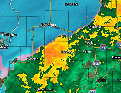
Rain changing to snow in northwestern McDonough and northern Hancock counties. Here she comes. Give me your best shot, winter!
-
1 minute ago, michaelmantis said:
(Hope this isn't too off topic...)
I'm surprised there are not more school closings posted yet (http://www.emergencyclosingcenter.com/complete.html) in the Chicago area...
Guess there still is time to make a call but with the later snow start, and blizzard conditions, I don't see how kids will be able to be picked up at 7 am, especially in rural areas (few miles west of where I am in Kane County).
Weirdly, we've had no closings yet either. All we've seen down here is over in Missouri, they're starting Hannibal-LaGrange late. People really have not been prepared enough for this storm...
-
Just now, King James said:
What’s your county?
.McDonough. I'm down at WIU. Really, really worried about travelers. 40 mph winds are nothing to mess with.
-
1
-
Nov. 25th-26th Midwest Snowstorm Potential
in Lakes/Ohio Valley
Posted
I believe it. We don't have any thundersnow down here, and we're a county below Roseville, but there's got to be 3-4 inches down out there. Erring towards 3.