

miamarsden8
-
Posts
113 -
Joined
-
Last visited
Content Type
Profiles
Blogs
Forums
American Weather
Media Demo
Store
Gallery
Posts posted by miamarsden8
-
-
Just now, Stebo said:
All timer
Like I work for a call center IT company, right, and it's based in the south. I never would have imagined in my lifetime I'd see Texas being 100 percent covered in WSWs.
-
6 minutes ago, Jim Martin said:
I think this is before the last couple of eastward bumps. Regardless, these percentages seem low.
-
1 minute ago, Snownado said:
I thought you were in Macomb, IL.
I was, I moved out to Cincy about a year and a half ago to try to get better opportunities. I also get much less fun weather out here...until this year.
-
 2
2
-
-
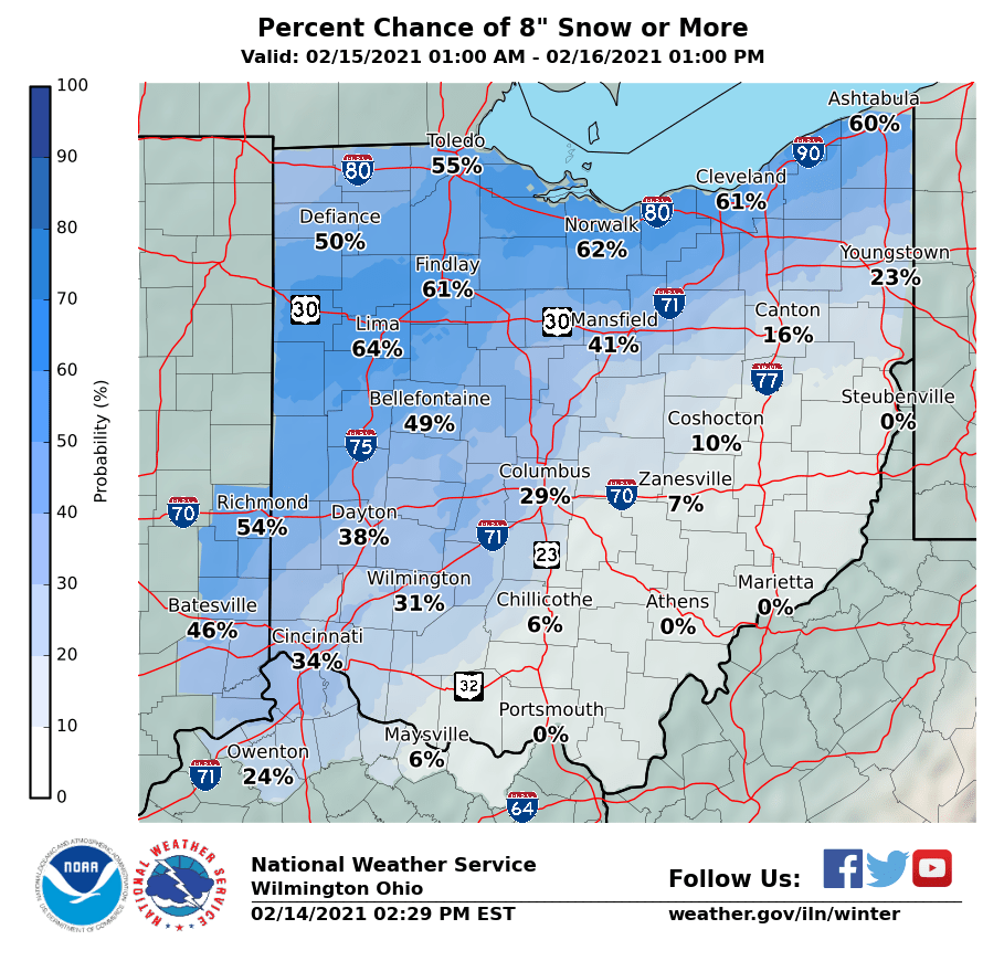
Welp, I'm getting nervous. This is not how I wanted to wake up at all! Stop trending northwest dammit!
Seriously, I am on the north side of Cincy, but based on these trends I'm glad I called 6-10. I'm not sure we get there.
-
So meanwhile, in Cincy, they're calling 9-12. I'm still not mega convinced, I'm in the 6-10 range, but even 6-10 with any wind would be a disaster out here. We may be in the bullseye, folks. Here's hoping we hit the jackpot!

-
2
-
-
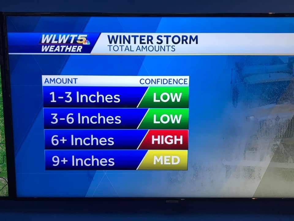
So meanwhile, in Cincy, the threat grows...high confidence for 6+ inches.
-
From the ILN area...
...WINTER STORM WATCH IN EFFECT FROM SUNDAY EVENING THROUGH
TUESDAY AFTERNOON...

* WHAT...Heavy snow possible. Total snow accumulations of 4 to 8
  inches. Some sleet and freezing rain may mix in with the snow
  across South Central Ohio and Northeast Kentucky.

* WHERE...Portions of East Central and Southeast Indiana,
  Northeast and Northern Kentucky and Central, South Central,
  Southwest and West Central Ohio.

* WHEN...From Sunday evening through Tuesday afternoon.

* IMPACTS...Travel could be very difficult. The hazardous
  conditions could impact the morning or evening commute.

PRECAUTIONARY/PREPAREDNESS ACTIONS...

Monitor the latest forecasts for updates on this situation.
Yep, I'm riding this. Only thing that could screw us is if it warms up too much, but I'm feeling this one. 4-8 is a fair amount, but I wouldn't be stunned if it's more.
All I know is that I told my s/o that Cincy has weak, boring winters. I have for one year been proven wrong.
-
1
-
-
My call as of the moment is 2-4 for the Cincinnati area. I don't buy above that because only a couple models have tracked in that direction, but I also don't buy that this will be a dusting of snow because of the way the temperatures are running colder.
But I have got to move north again one day. I miss western Illinois snowstorms. At least 6-8 inches is fun and we'd get 20 inch weenie runs sometimes to be excited about.
-
Reading through these forums, it's depressing moving from the Western Illinois University area, where we see at least some weenie number from time to time, to the Cincinnati metro area, where we're riding the line between 2 and 6 inches. Can we get a 20 mile south Euro shift?
Doubtful, but I can hope.
-
1
-
-
Just now, ILwxchr said:
Yeah its really bad. I'm from Galesburg and a friend of mine is stuck in the country and I'm up here and its just not a good situation. Officials know about everything that is going on, but just nothing anyone can do right now because the conditions are so bad.
It's especially crippling for rural areas when this stuff happens because seriously, how do you go around to every spot in the county to help people? You just can't.
-
 1
1
-
-
Just now, donsutherland1 said:
This could be a pretty special event.
Some November snowfall records for Macomb:
11/25 daily record: 1.2", 1993
11/26 daily record: 2.8", 1940November daily record: 6.0", 11/15/1925
Biggest November snowstorm: 8.5", 11/17-18/1926
November snowstorms with 6" or more snow: 3
Yeah, we've shattered most of those.
-
2
-
-
Knox County update for all of you in/interested in Galesburg...
The situation has degraded in the most recent (attached) Situation Report from the National Weather Service. Wind speeds are now up to 50 mph and our snowfall will likely hit 10". Looks like several more hours of snowfall yet to come.
Even with 4 dispatchers and three call-takers working non-stop, Knox County Dispatch is inundated with calls. A large number of motorists are stranded on area roads, mostly I-74. In particular are quite a few WIU students apparently trying to get back to Macomb following the Thanksgiving break. With little to no visibility, most all response capability to these motorists is on hold. Tow vehicles have suspended operations and the local Snowmobile Team is only responding to high priority calls. Most Township Road Commissioners have also suspended operations. IDOT and ISP are swamped as well as the situation north of Knox County is apparently even worse. Most Township Road Commissioners have also suspended operations. We will attempt to get to these folks as conditions and responder safety improves which could be toward morning.
Here in Galesburg, the snowplows have been out for a few hours but are finding the wind and new snow filling the streets pretty quickly after plowing. They are concentrating on priority routes and working with emergency response agencies to insure they can get in and out of the stations and to the life-safety related calls.
Ameren is telling us the power outage in Galesburg will likely be for another 6 hours. There are currently about 1600 residents without power. There are smaller outages out in the county.
Galesburg Fire has been running non-stop on calls since around 5:30. Many of these are arcing and sparking wires and transformers. A few trees have fallen on utility lines. We had smoke in a big box retail store earlier that was caused by a heating unit on the roof. We have also answered calls for stranded motorists. Fortunately, we have not had an excess of medical related calls since the storm began.
In Galesburg, we have received no calls for shelter needs as yet which is a testament to the character of our Midwestern folks. Rio and Oneida have opened their fire stations as warming centers and have some customers there.
WGIL is typically not manned on Sunday nights, but they have been great to get down there to broadcast some of our information.
Kudos to all our emergency response people for their great work and for those citizens who chose to stay in and watch the ballgame tonight.
Chief Simkins
-
1
-
-
Do you know how rare it is for Macomb to actually get hit by something good? We used to make a joke in our professor's class that he was a bad luck charm and kept tornadoes from hitting Macomb.
-
Here, I thought you folks might be interested. This is right outside my apartment, and it's not often I share anything like this.
-
3
-
-
So uh...6.5 inches, maybe more out there. 45 mph gusts, 35 mph winds. Looks great out here, and my forecast so far is still good. I'd call it a good day, folks.
![rsz_img_20181125_214031[1].jpg](https://www.americanwx.com/bb/uploads/monthly_2018_11/1607895964_rsz_img_20181125_2140311.thumb.jpg.e0700f25243063187dc25f071a3759b1.jpg)
-
2
-
-
Just now, ILwxchr said:
A lot of power outages too in the Galesburg/Macomb area. Multiple power poles snapped in McDonough county. I believe they pulled the plows as well but don't quote me on that.
They did, as well as all police cars. They even stopped the gowest service. Like...it's crazy.
-
1
-
-
Just now, ILwxchr said:
67 is closed from what my buddy who works with the EMA told me, multiple plows and state police stuck. Several of my friends also got stuck in town too. Heard a report of 6.5" so far southeast of Macomb. My instructor also backed that up saying 67 is a no go. 74 is also a no go from QC to Galesburg.
Can confirm the 67 thing. They probably didn't have too much of a choice. I was telling them on their Facebook that they need to shut it down because people are stranded, like, come on.
-
1
-
-
Just now, ILwxchr said:
WIU is closed tomorrow, so I don't have to worry about making my commute back until Tuesday afternoon. Nice to have an extra day off. Couple 14 inch reports up just north of me where that death band was earlier today. I went out and attempted my best and got several measurements between 12 and 14 inches at 8:30 north of Davenport, IA. Hard to be accurate with strong bursts of wind and snow still ripping hard. Guessing we will end up with another couple inches before its said and done. Depending on how fast the back edge pivots around...figured someone would end up with 15 inches out of this. Best snowstorm I've seen since 2/1/2011 anyway. I'm satisfied.
I'm actually shocked they closed it to be honest. It's 4-5 inches, 30 mph winds down here, though, and the commute has left people stranded, so...yikes.
-
1
-
-
Just now, Natester said:
That kind of pastry on trees reminds me of 2/1/2015 where there was a few hours of rain before the changeover to snow.
Yeah, it all changed over at like...4:30? So I think the roads are worse than anyone thinks because it mixed for a couple hours.
-
Visibility view.
![IMG_20181125_205443[1].jpg](https://www.americanwx.com/bb/uploads/monthly_2018_11/1579868420_IMG_20181125_2054431.thumb.jpg.d917d3a3e419e767af1a0aa422345d8c.jpg)
-
3
-
-
They've taken all police off the county roads now. Here's my view...
![IMG_20181125_205545[1].jpg](https://www.americanwx.com/bb/uploads/monthly_2018_11/1717915475_IMG_20181125_2055451.thumb.jpg.59da89fa29ba24ddeee071371c86843b.jpg)
-
2
-
-
It's like Christmas, except without all the people.
![IMG_20181125_200441[1].jpg](https://www.americanwx.com/bb/uploads/monthly_2018_11/2095032931_IMG_20181125_2004411.thumb.jpg.7468920ab046434abf6bea467659cc0a.jpg)
-
3
-
-
WIU called school off. Finally. God.
-
Western Illinois University says they don't plan to make any closing decisions until sometime before 5:30 a.m. That doesn't help all the commuters stuck...
![rsz_img_20181125_214031[1].jpg](https://www.americanwx.com/bb/uploads/monthly_2018_11/980106767_rsz_img_20181125_2140311.jpg.16b74e13fe1c31c2cdef99937d2307d1.jpg)
![IMG_20181125_205443[1].jpg](https://www.americanwx.com/bb/uploads/monthly_2018_11/599271757_IMG_20181125_2054431.jpg.1f165249b5035584b7632d53cc27f8e8.jpg)
![IMG_20181125_205545[1].jpg](https://www.americanwx.com/bb/uploads/monthly_2018_11/1211691771_IMG_20181125_2055451.jpg.c1fb2c0ef8ff1f69cbc5d74cce3cb92d.jpg)
![IMG_20181125_200441[1].jpg](https://www.americanwx.com/bb/uploads/monthly_2018_11/972115993_IMG_20181125_2004411.jpg.3dc07d4417fb36ae2b7b9f12c7d6a073.jpg)
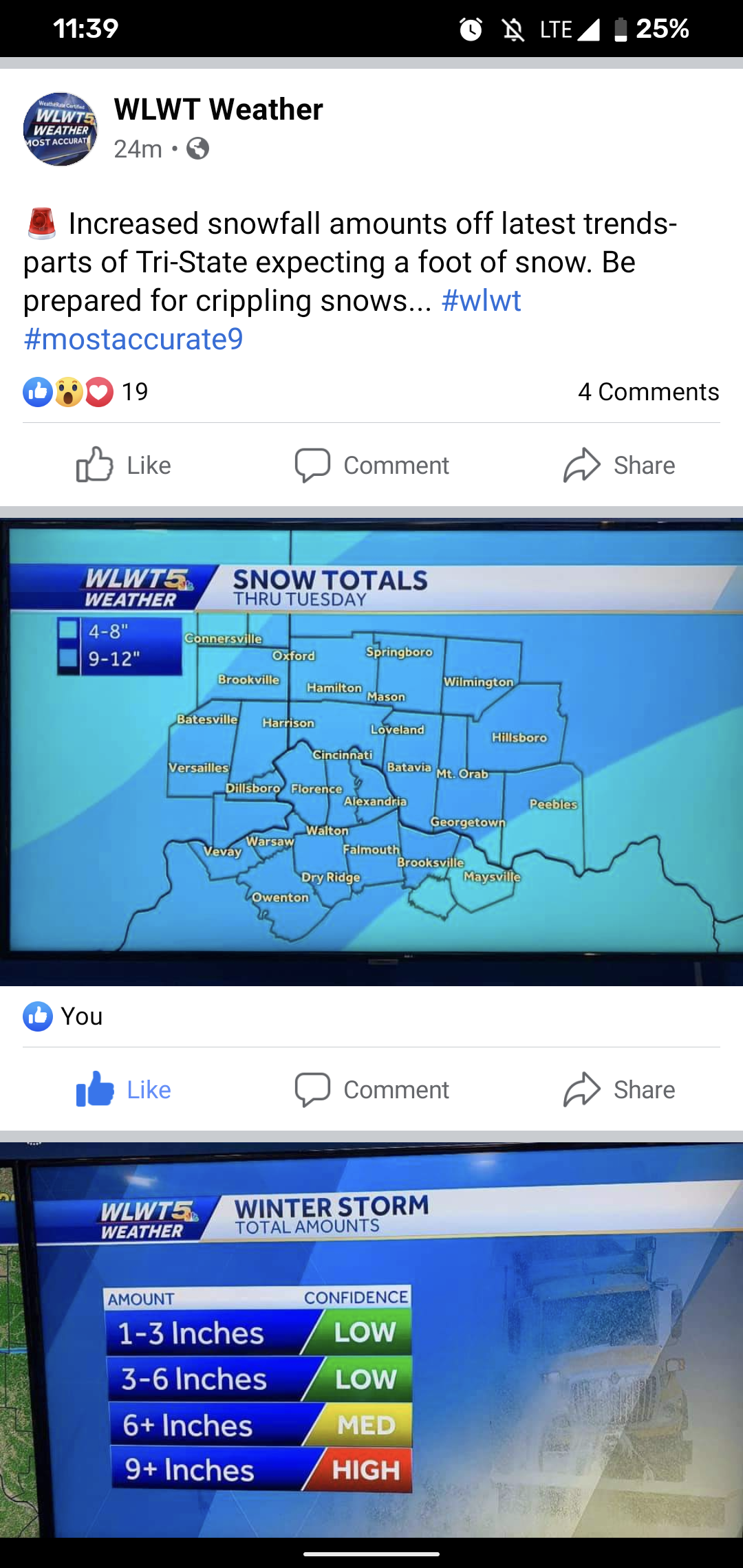
February 14-16 Winter Storm Part 2
in Lakes/Ohio Valley
Posted
After the kuchera euro, if we are to trust they fixed the bug, 12 inches is possible in Cincy. I am terrified of another NW shift though, it's getting too close to those lower amounts for me.