Gosnow
-
Posts
44 -
Joined
-
Last visited
Content Type
Profiles
Blogs
Forums
American Weather
Media Demo
Store
Gallery
Everything posted by Gosnow
-
Graupeling here in lititz. Little bit laying on deck and grass. Very cool.
-
Lt snow lititz.
-
Anything on the long range to look forward to? It was mentioned perhaps one more hurrah in late March or is that off the table?
-
Driving from granville to lititz snow all the way. Roads did not cave until I hit 322 east. Snowing moderately here in Lititz.
-
All nice and white in Lancaster county. Prob around 1.5 to 2 in. Gotta love little storms that can over deliver.
-
Mr Horst saying March could be the snowiest month. Perhaps the new Feb http://www.atmos.millersville.edu/~wic/SWD-latest.html Here is to tomorrows start. March 1st. Personally I think this first one will over perform and we see 3 to 4 in Lanco tomorrow.
-
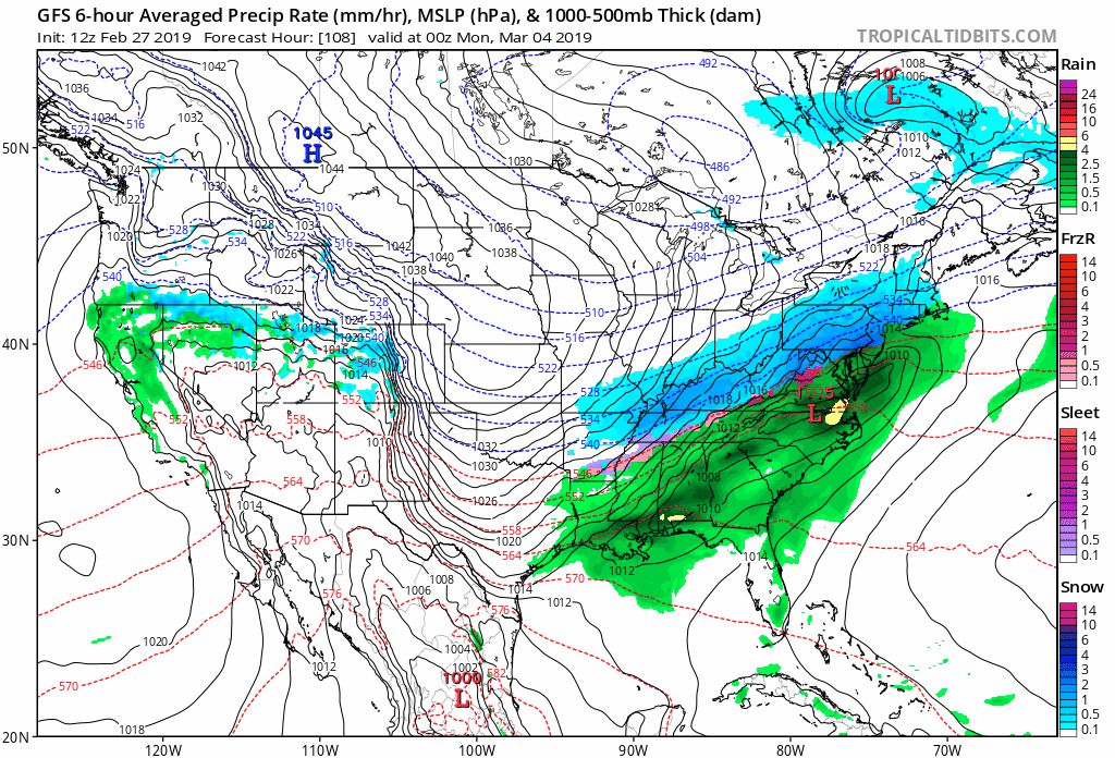
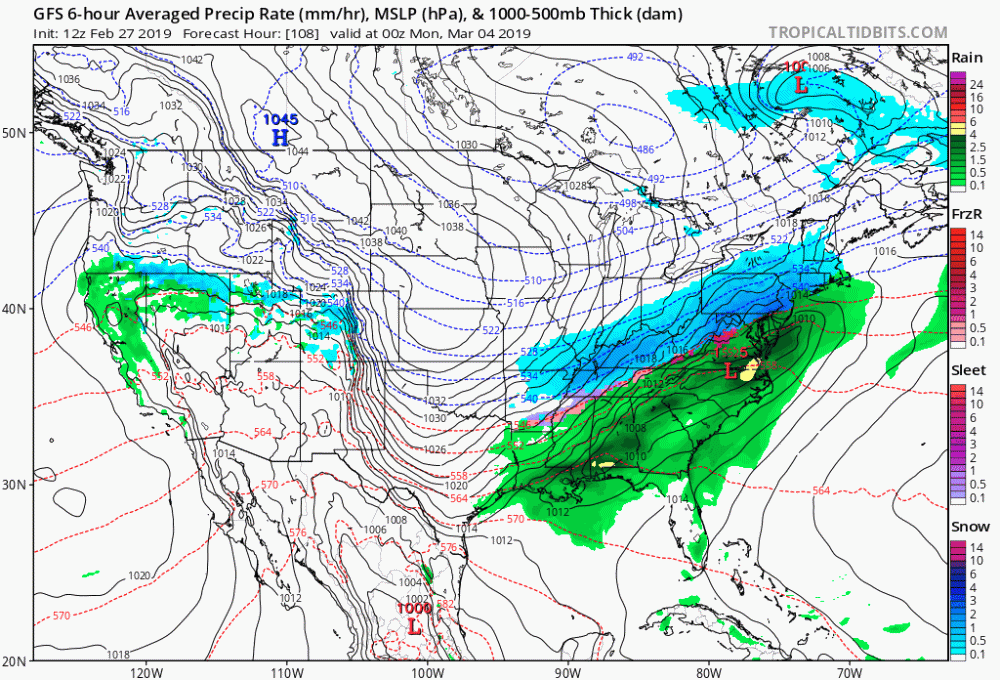
12z gfs looking mighty interesting for sunday Monday now. What a difference a day makes. Of course until the next model run.
-
On wgal tonight Joe Calhoun normally pretty conservative was saying that the ingredients were coming together for a storm if not next weekend then the start of the week after. Could be he is referring to the storm showing up in the long range. If as everyone has been saying everything is coming together perhaps it is our time. I think someone said March could be the new February.
-
Central PA - Jan/Feb 2019 Obs and Discussion
Gosnow replied to MAG5035's topic in Upstate New York/Pennsylvania
I think this will be good test of the models seeming to show the CAD staying strongeracoss all levels than what we have seen in the past. How many times have models seem to bring in the warmth faster than what we have experienced? -
Central PA - Jan/Feb 2019 Obs and Discussion
Gosnow replied to MAG5035's topic in Upstate New York/Pennsylvania
6pm gfs gives us hope for early next week although it seems that the initial push of snow is now south in Virginia and then afterwards up our way. At least it is something to hold hope out for. -
Central PA - Jan/Feb 2019 Obs and Discussion
Gosnow replied to MAG5035's topic in Upstate New York/Pennsylvania
About 2 to 3 here in lititz and still snowing nicely. -
Central PA - Jan/Feb 2019 Obs and Discussion
Gosnow replied to MAG5035's topic in Upstate New York/Pennsylvania
Lightly snowing in Lititz. Nice to see amounts get upped in the short term vs going down. Heard from wife schools starting to cancel. -
Central PA - Jan/Feb 2019 Obs and Discussion
Gosnow replied to MAG5035's topic in Upstate New York/Pennsylvania
Concerning weather models and global warming. I am familiar with modeling but not weather modeling. The question i would think is how much of a model starts from historical values or averages. As the weather changes over time those I think those could become out of step with current conditions. A model reading real time data which I would guess they all do sampled within the past few days or week I would think those would have more weight in the algorithms. I think for the most part they get general features right it is the details that get muddied which is I know what usually concerns us most. -
Central PA - Jan/Feb 2019 Obs and Discussion
Gosnow replied to MAG5035's topic in Upstate New York/Pennsylvania
Being a former buffalonian I follow their weather discussions. Here is what they are seeing per their 258 PM discussion which seems to be spelling out our issues in the lsv especially Lancaster and surrounding counties. We needed phasing later not earlier. As mentioned...the center of the cyclone was found over the Lower Mississippi Valley at 15z. The system will track to the northeast across Kentucky and West Virginia to about the Mason Dixon Line... which is about 25 to 50 miles further north than most guidance packages were suggesting. This subtle shift is being verified by pressure falls over Ohio and West Virginia. If this trend continues...it should lead to slightly stronger winds and possibly more snow. The reason for the shift is an earlier phasing of the two branches of the jet. This is starting to become apparent in WV imagery. -
Not comforting for us in the lsv for all snow But glad to hear up north could see a whole bunch. Still time to change. Really need the blocking to hold in the cold. It always is a matter of timing and blocking.
-
Thank you! Live in Lititz and a weather hound. Love snow most of all. Yeah this will be interesting to see how it unfolds.
-
State college in afd hinting at perhaps heavier amounts due to deformation zone for se areas. Perhaps some bonus snow. Model Cycle and latest SREF indicates the potential for 2-3X the snowfall forecast for the far SE zones thanks to a mesoscale deformation zone just to the north of a compact 700-500 mb closed low Sunday afternoon into early Sunday evening. The SREF shows the nose of a -2 to -3 sigma, u-wind anomaly (easterly LLJ) pointed right into that area. There will be a very tight SSE to NNW gradient in snowfall within 20-30 miles north and south of the I-76 corridor. Will take the measurable approach to gradually increase amounts across our far SE zones (near and to the south of a KTHV to KLNS line Sunday into Sunday evening), but still keep the bulk of Lancaster and York counties below Winter Storm Warning criteria of 5 inches for now. BUFKIT time/height cross sections show a distinct second period of moderate to briefly heavy snow from about 22Z Sunday to 04Z Monday INVOF KLNS and points south from this potential deformation snow band.
-
Snowing pretty hard in lititz. Nice pleasant surprise. Winter storm warning posted at 1:28pm for Lancaster county. Woot.