
fluoronium
-
Posts
205 -
Joined
-
Last visited
Content Type
Profiles
Blogs
Forums
American Weather
Media Demo
Store
Gallery
Posts posted by fluoronium
-
-
Just realized that the temps on May 3rd were the first below average daily temps in May since 2017 for some locations in IL (Lincoln and Springfield at least) as last May had 0 days below average.

Yesterday was super nice, but it's back to cool/cloudy yet again today. Normally I'd complain about this kind of weather, but the constant rain and lack of hot/sunny stretches has led to an unbelievably awesome morel mushroom season. I've picked so many I'm giving them away to friends/family because I cannot possibly eat them all. -
If LOT pulls the trigger on a WSW, would this be the latest in the season they have ever issued one? I don't know where to find this info.
I'm actually considering driving north to snow chase. Normally I hate spring snow, but this is just too wild. It looks like the majority of the snow will fall during the day in IL/WI which is literally insane. -
Found my first morel of the season yesterday, which is about a week later than normal for me. This has shifted later in recent years though.
It's hard to believe that I'm sitting within 1ºF of average this month as it feels like it's torching here compared to last year. Thunderstorms have been lacking, but there have been so many nice warm days that it's really hard to complain. To top it off that freak snowstorm last week ended up being an incredible event to witness. Normally I abhor the thought of snow in April, but the sheer intensity of the snow followed by such a dramatic warm up to the mid 70's two days later was something I have never seen before.
-
 1
1
-
-
Still snowing here but now it is melting faster than it is falling. Max depth I got to was about 3" of total slush. Lots of small branches down. It is supposed to be 75F just two days from now.
The first snow of the season was October 12, which was over 6 months ago. I normally would be unhappy about snow this late in the season, but the sheer intensity of it at this time of the year was actually pretty cool. Also unlike last April, there is warm weather immediately ahead. I really hope this was the last snow of the season though.-
1
-
-
This is some of the heaviest snow I've ever seen. Unfortunately no thundersnow here though. A big branch fell onto my raspberry patch and smashed a bunch of my plants. The wind has been pretty strong too.
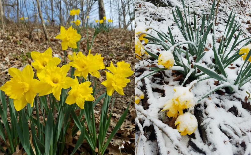
I took the picture on the left yesterday, and the one on the right this morning.
-
Snow absolutely dumping now. Have about 2" on concrete on everything. A few smaller branches are down from the heavy weight of the slush on the budding trees. I have never seen such heavy snow after the flowers and trees have bloomed out.

-
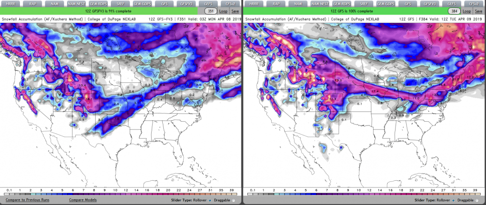
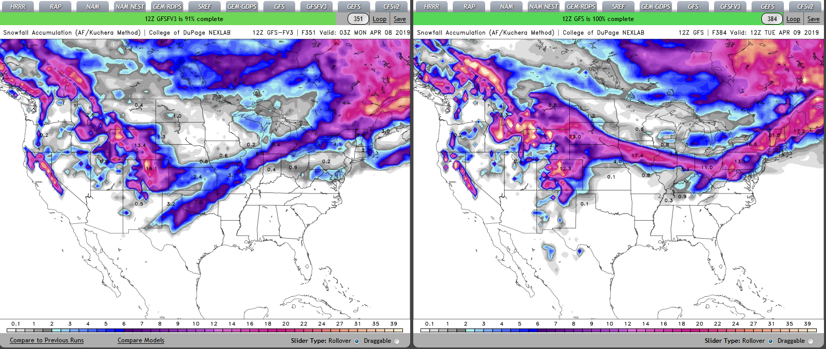
Am I allowed to complain about the fantasy range on the forecast models? Reason being is that all of that snow for my area on the GFS/FV3 (and even a bit on the Euro) is a bit frightening. I don't think my morale can handle another "winter in April" like last year, and my plants certainly wouldn't appreciate it either.
-
 1
1
-
 1
1
-
-
Solid B here. Highlights were the tornado outbreak on December 1st, early January warm spell, and the 11" snowstorm on Jan 12th. Worst part of the winter was February. Somehow we managed a long streak of below average temps/above average precip with almost no snow. I lost count of how many times we had 33 and rain. If it isn't going to snow I'd rather it be torching outside.
Now onto "spring" which is starting out as an F here... -
Dropped to -2F here last night on a nearly bare ground. In March. No thanks.
-
The number of 33 and rain events I had this past week was incredibly disappointing. I seriously would have preferred a crippling ice storm over that. Now I will say that the thunderstorm that rolled through here very early on the 6th was pretty interesting as I had never seen such heavy precip at only 33 degrees.
-
It is amazing to see the NWS have all time STATE lowest temperatures in their official forecast. I found some places on the point and click map with a low of -37F. This is an incredible event.
I won't see quite as ridiculous temps where I live but Peoria is supposed to tie their all time low temp at -27F.
-
47 minutes ago, The_Doctor said:
I've seen -36F thrown around a lot as the record coldest in Illinois. Is the -37 in Rochelle in 2009 not counted? Sorry I'm not familiar with how records are determined/validated.
The -36ºF at Congerville is considered the official record. From the IL State Climatologist Website:
QuoteThe lowest temperature reported in Illinois was -36°F in Congerville on January 5, 1999.
It is important to note that some sources, including Wikipedia, have list -37°F in Rochelle on January 15, 2009 as the lowest temperature in Illinois. However, that observation came from a small airport station designed for aviation purposes and was not part of the climate network in Illinois. As a result, the data were not always archived and no quality control procedures were applied to the data. In fact, sites in that network (Automated Weather Observing System or AWOS) do not record the minimum temperature, only the temperature every 20 minutes. In addition, temperatures below -30°F were very close to the design limits of the equipment. An examination of the site, the available 20-minute data (before, during, and afterwards), and the equipment, along with the consideration of the meteorological factors of that morning, raised questions about the validity of the one data point. As a result, it was never officially recognized as the state record.
-
 1
1
-
-
To add to the extreme climate discussion, North Dakota recorded a low of -60ºF and a high of 121ºF less than 5 months from each other in 1936.
https://www.weather.gov/bis/climate_EXT
As for my complaints, I am concerned that this bitter cold snap is going to kill half of my fruit trees. I live in USDA plant hardiness zone 5b which means an average annual minimum temperature of -10ºF to -15ºF. We have gotten below that the past 3 out of five years here. Recent updates to the map have most areas warmer than what they were in the past, but if polar vortex visits are going to become more common here, lots of places in the midwest will need to be dropped a zone.
-
I remember a storm in 2003 where there were severe thunderstorm warnings issued in central IL for a line of thunderstorms/heavy snow associated with a strong cold front. Is there any possibility of that kind of event with a setup like this for those south of the low? This storm system looks to take a similar path to the 2003 storm, and the forecast models are picking up on a line of precip associated with the cold front.

I would love to see something like that again. We had a short burst of whiteout conditions with tons of lightning, and the wind blew the snow in my yard into snow rollers. Some info on the 2003 storm can be found here: https://journals.ametsoc.org/doi/full/10.1175/2008WAF2007103.1 -
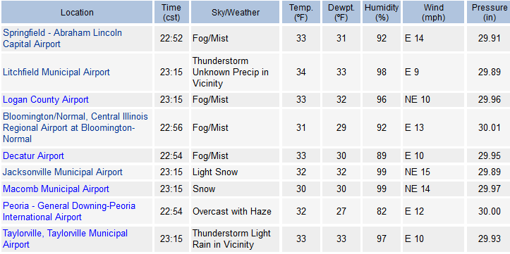
ILX just issued a SWS for 1-2" of fluffy snow this afternoon. This combined with the surprise ~2.5" of fluff I got yesterday is an excellent consolation prize for the potential rain I'm going to get on Monday.
Quote...Another Round of Accumulating Snow This Afternoon to Early Evening... Snow will develop across central and eastern Illinois today, and diminish this evening. One to two inches of accumulation are likely, with the higher amounts northeast of a Havana to Charleston line. With very cold temperatures in place, snow will quickly accumulate and cause slick roadways. Motorists should be ready for snow covered roads and slow travel this afternoon and evening.
-
Actually the IL all time coldest temp was recorded in Congerville, not East St. Louis. Pretty crazy that -36ºF was recorded so far south in the state. I live just a few miles from Congerville so I will be disappointed if our record gets taken away from us by a place further north in the state.

-
1
-
-
A couple places near the rain/snow line in IL are reporting thunderstorms. I wonder if thundersnow is a possibility for me tonight...
-
1
-
-
3 minutes ago, n1vek said:
I would love to see that map extended to the east another 500 miles.
Here you go! From https://weather.cod.edu/forecast/-
1
-
-
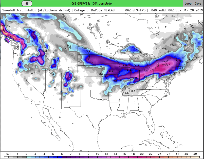
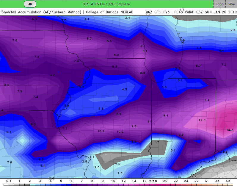
I know I'm being greedy, but I don't like being in the doughnut hole that's showing up on multiple models. Heavier snows in every direction around me. Still though a 5" snow would be nice, but I've been spoiled from the recent storm.
-
ILX adds another county to the WSW. Judging by the recent HRRR runs, they will have to add the last two northern counties also...
QuoteWinter Storm Warning
URGENT - WINTER WEATHER MESSAGE
National Weather Service Lincoln IL
1028 AM CST Sat Jan 12 2019

...Heavy Snow Across Central Illinois Today...

ILZ027-130030-
/O.UPG.KILX.WW.Y.0001.000000T0000Z-190113T0600Z/
/O.EXA.KILX.WS.W.0001.000000T0000Z-190113T0600Z/
Knox-
Including the city of Galesburg
1028 AM CST Sat Jan 12 2019

...WINTER STORM WARNING IN EFFECT UNTIL MIDNIGHT CST TONIGHT...

* WHAT...Heavy snow. Additional snow accumulations of 2 to 4
  inches. Total snow of 6 to 7 inches.

* WHERE...Knox County.

* WHEN...Until midnight CST tonight.

* ADDITIONAL DETAILS...Travel could be very difficult.
-
ILX has issued 2 WSWs and 1 blizzard warning for my county in the past year, and none of them had watches beforehand.
I'm not complaining though, after getting an inch in the November storm as well as multiple years without a WSW, its looking like my area has a solid shot at exceeding 6" in this storm. Plus with that stretch of nice warm weather we had last week, this is shaping up to be a good January for me. I can't wait to see what the highest totals in Missouri will be!
-
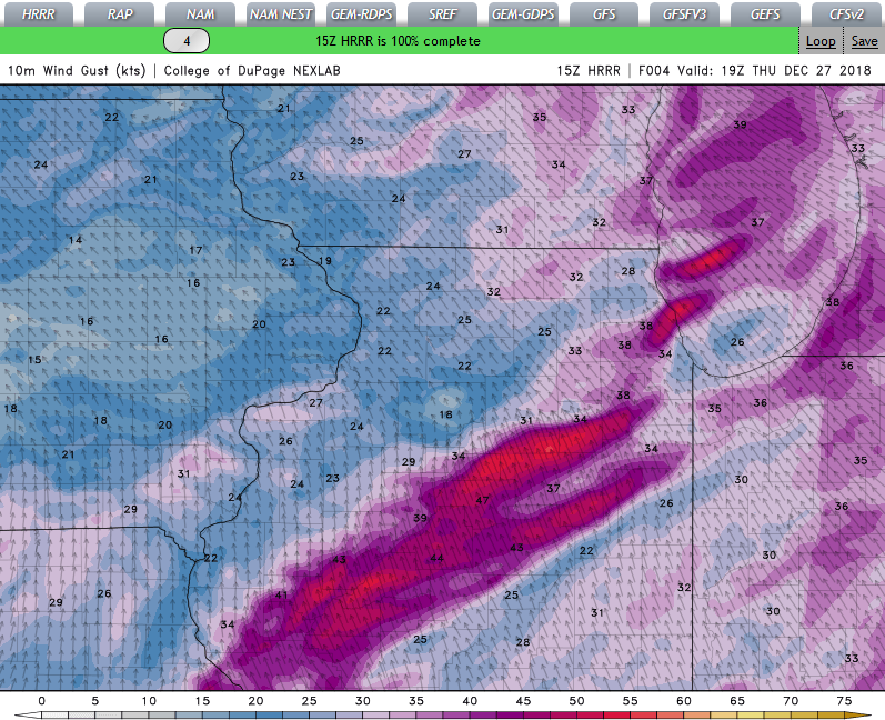
HRRR is picking up on some pretty intense wind gusts here over the next few hours. ILX doesn't even have an advisory out for us.
-
This year it felt like both spring and fall were skipped here and the seasons seemed to transition directly from winter to summer to winter. I did a calculation for Peoria, IL to see how the daily temps this year compared to normal. My criteria for spring/fall like weather was highs in the 60s and 70s. The "average" number of days with highs 60F to 79.9F is 109 per year. That is, the daily average high temp is in that range from April 8 to June 6 and from September 9 to October 27. This year there were only 65 days in that range, or 59.6% of normal. I can't say I am a fan of skipping the transition seasons.
-
3
-
-
Currently sitting under 15/15/5 probabilities which pathetically is one of the highest of the entire year here. Maybe I will be lucky enough to get my first tornado watch of 2018.

September 2019 General Discussion
in Lakes/Ohio Valley
Posted
I chased that supercell today and saw the tornado near Emden!