
fluoronium
-
Posts
205 -
Joined
-
Last visited
Content Type
Profiles
Blogs
Forums
American Weather
Media Demo
Store
Gallery
Posts posted by fluoronium
-
-
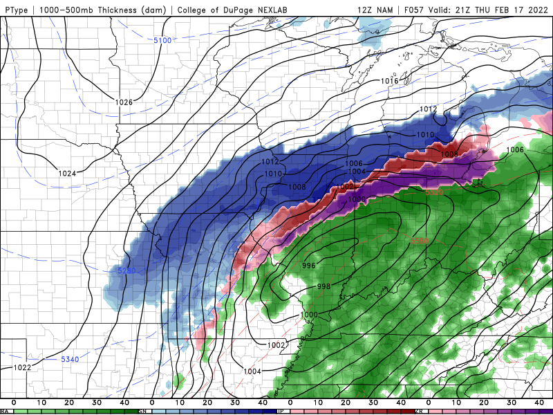
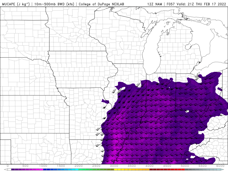
06Z NAM still had good overlap of instability in areas receiving snow and sleet. I'm really hoping we get some thundersnow out of this. I'm willing to drive to see it if it doesn't happen directly over my area.
-
16 minutes ago, Chicago Storm said:
Browsing through NAM soundings, and they are supportive of TSSN potential.
What do you look for on a forecast sounding to identify thundersnow potential? I see the NAM has mid level lapse rates in excess of 7C/km and MUCAPE values over 100J/kg in areas receiving frozen precip. There is a lot of shear as well. Is there anything else to be looking for?
-
NAM is quite generous with upright instability in areas receiving frozen precip. All of the models have substantial frozen precip rates regardless of where the storm ends up. Maybe there's a good shot at thundersnow somewhere with this???
-
I managed to squeeze out about 10" here. Ratios were a lot lower than models predicted (as was suggested by people here in the days leading up to the storm)
It wasn't the historic monster I had hoped, but it was still the biggest snow for me in 3 years so I can't complain.
-
 2
2
-
-
-
49 minutes ago, vortex said:
Where you located?
I'm near Goodfield, which is between Peoria and Bloomington.
-
1
-
-
Wow it's absolutely dumping snow here now. I don't know how I'm going to manage to sleep tonight.

-
Switching over now, very slippery layer of frozen slush on paved surfaces. Untreated roads are slick in spots as well. I don't think the warm day did much thawing of the ground. I guess those days going below zero with a bare ground have paid off.
HRRR, NAM, and 3km NAM have me right in the bullseye for the biggest snow storm of my life.

-
1
-
-
ILX is mentioning a possible upgrade to blizzard warning for round two.
QuoteThe other main concern is the potential need for a Blizzard Warning on Thursday, as the strongest winds during this event occur during the afternoon. Gusts of 30 to 40 mph will blow the snow, creating white-out conditions at times, especially for roads in open areas. We held off on changing the headline to a Blizzard with this update, but this will be a concern going forward depending on the actual snowfall amounts.
-
3
-
-
y break up the threads though
-
1
-
 1
1
-
-
It's beautiful outside now. Most of my best storms in recent years have started with anomalously warm temps the day before the main event.
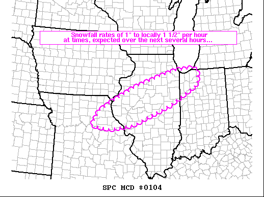
HRRR is suggesting some heavy banding further west in central IL. Peoria area posters would like this scenario.
-
34 minutes ago, Chambana said:
anxiety and anticipation has taken over, this might be CMI biggest snowfall on record.
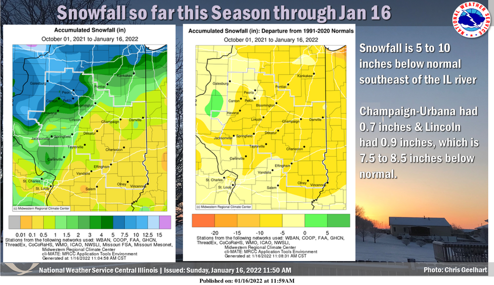
This is quite a change compared to such an abysmal start to winter in eastern IL. Has Champaign even received a 1" snowfall yet this season?
-
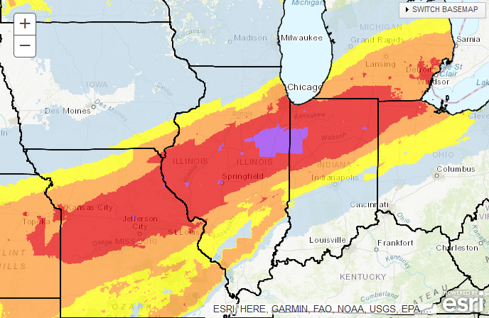
Decent sized area of "extreme" shown on the winter storm severity index forecast.
-
What are the chances of lightning in the the heaviest bands here? I've seen thundersnow from intense fgen bands before but I really don't know what to look for on the models to have an idea of this possibility. From my understanding, slantwise instability isn't apparent from simply looking at skew-T diagrams, and there's probably more to it than just a sharp horizontal temperature gradient. I'd love to hear input from some of the more knowledgeable members here.
-
30 minutes ago, WeatherMonger said:
Has to be a Chicago area lake effect event, here in Springfield our single 24 hour record is 17.4" from the Palm Sunday snow in 2013.
It actually wasn't. That 36" in 24 hour snow total was in Astoria, IL in 1900. There must have been some tight banding with that system, since Peoria only received half of that.
https://www.ncdc.noaa.gov/extremes/scec/records-
1
-
 1
1
-
-
Bonkers seeing ensemble mean totals like that.
The operational 18z GFS is nearly an all time weenie run for my backyard. It would be incredible to have such a garbage season drop a monster storm of even half of what was is modeled there. I know it has happened to Chicago in recent years, but I've missed out on most of the fun in recent Februarys.
-
1
-
-
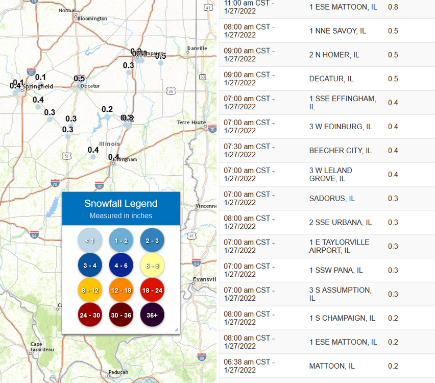
Crazy things happening in east central IL this morning, with multiple locations already reporting the biggest snow of the season. Effingham's accumulation is roughly infinity times larger than their entire season to date snowfall.
-
1
-
-
Wind chill advisory and a bare ground. Rough times here in central IL.
-
Not a good look going into an extended period of cold and dry.

-
20 hours ago, Cary67 said:
Lost two Japanese maples to that late January cold snap
I lost all of my rhododendrons and a lot of other plants rated for zone 4 in that cold snap, and I'm in zone 5b. Now I welcome these sudden cold snaps, since they are good for beating down invasive insect populations like Japanese beetles and emerald ash borer. Plus, what plants I had survive that snap should be able to tolerate future extreme cold here.
-
1
-
-
Oh here's a scary/cool video from this outbreak:
-
3
-
1
-
-
I have no idea what he was thinking, since models had been consistent on an outbreak setup for at least a week prior to that. I mean just the anomalous warmth in December alone is a pretty solid bet for at least some severe weather.
In Broyles defense, he did call the 3/28/20 crapvection bust 4 days out, and he was also the mastermind behind this amazing resource for violent tornadoes: https://www.spc.noaa.gov/exper/outbreaks/outbreaks-small.php#
-
1
-
-
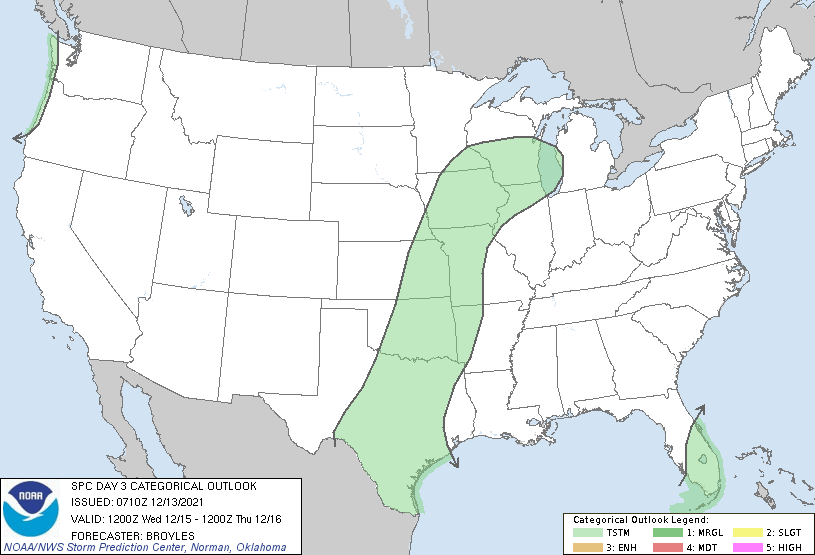
3 hours ago, cyclone77 said:
On the SPC past events page the original day 3 is gone, as only the updated midday day3 update shows up. Was hoping to go back and have a laugh at that original day3 but it's been edited out of existence, at least on the SPC past events page.
I'm glad I saved a copy of this gem. We can't let the SPC cover up this one
-
1
-
1
-
2
-
-
I've been sitting right at the cutoff most of the day, getting a mix of sleet and snow accumulating to about 2". For such dense ratios, the snow is surprisingly dry and not sticking to the trees much.
Funny how winter is finally starting here on January 1st, just like last year.

Feb 16-17th Winter Storm
in Lakes/Ohio Valley
Posted
I'm sitting pretty much in the bullseye for snow totals right now. It would be crazy to get two major storms back to back in just two weeks. I've seen places to my north get hammered repeatedly in recent Februrarys so it's nice to finally cash in on the snow train! The icing on the cake would be thundersnow, but it seems models have down trended the instability as the storm gets closer.