

Miss Pixee
-
Posts
316 -
Joined
-
Last visited
Content Type
Profiles
Blogs
Forums
American Weather
Media Demo
Store
Gallery
Posts posted by Miss Pixee
-
-
26/5DP
Powdery dusting on cars and grass.
-
 1
1
-
-
Placed food order for delivery today...never know if P15 is incoming...

-
On 1/6/2024 at 9:11 PM, Interstate said:
Your DP cannot be more than your temp
I thought that seemed squirrely, but I'm no met...dang app.
-
4 hours ago, Weather Will said:
WB 6Z GEFS

P15, please. Will settle for P28...hee hee
-
1 hour ago, Interstate said:
This seems incorrect. Might want to get your station tuned up.
What seemed off? Not sure.
-
38/41D
Total washout.
Only flakes I've seen are a couple of neighbors stumbling around in the rain.
-
Holding steady at 37/36D
Getting pounded with rain. Overcast skies a bit darker.
-
11 minutes ago, TSSN+ said:
Icy rain at 37? Lol
It's thick and heavy (you can hear it hit the ground) but it isn't freezing rain on the pavement, just wet.
-
37/36D
Very heavy icy rain.
-
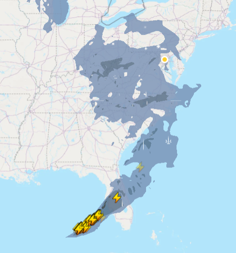
System is shaped like a big comma. Darker portions are moderate rain/snow. Yellow dot is DC.
-
33/29D
temp ticked up 2, dewpoint up 5 from 2 hours ago.
My baby trees will enjoy the rain so I take a positive out of it. Good day for football, horror flicks and eats. Maybe some seafood/wine later.
Goooooo Browns, Steelers, Dolphins, Lions
Cowboys and Eagles suck.
-
31/23D
tick up in temp, dewpoint not budging.
-
30/23D
dewpoint steady 7 hours...
-
30/23D
light clouds
-
35/23D
Booya.
-
37/25D
dropped in last 15 minutes
-
As of now
38/26D
Crystal clear skies
-
I think one of the Mets here is familiar...
"Dmv" here is Department of Motor Vehicles
"The" DMV is DC/MD/VA
Whether its news, sports or politics, that's how we roll!
That being said better luck next year Commanders.
Gooooo Browns
-
2
-
 1
1
-
-
6 minutes ago, pazzo83 said:
DC - MD - VA
Yup. I thought the hipsters here knew that...
-
1
-
 2
2
-
-
The DMV is not impressed.
However, these maps will make great wallpaper for my guest room.

-
On 1/1/2024 at 10:11 PM, cbmclean said:
That's a major accomplishment for the UHI capitol of the western world.
I guess if you just go by the downtown core. That term could apply to most cities. Baltimore is north but has a helluva lot more concrete.
-
A crisp 27 degrees in SE DC. 6:25AM
ha haaa
-
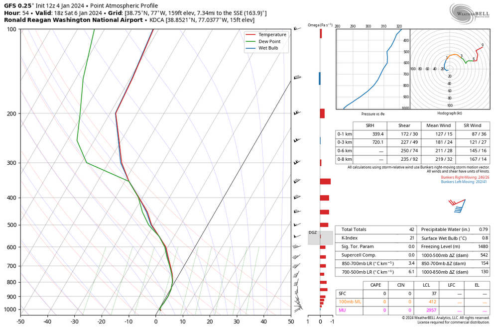
1 hour ago, nj2va said:
18z Saturday sounding at DCA. Super close but did get a tick colder than 6z at the same time.
My neighborhood has volunteered to put bags of ice on the streets if that will help!
-
3
-
1
-
-
On 12/19/2023 at 8:20 PM, Ji said:
Im actually really tired of talking pattern change. We do need a threat asap to show up. Those maps are pretty but we need some roi like right now
But...whom are you going to complain to?

-
1
-


Jan 15-16 Storm Thread 3: Obs and Disco
in Mid Atlantic
Posted
27/13DP
Cloudy, off and on light snow. ~1". Street snow in patches.