
Kasper
-
Posts
425 -
Joined
-
Last visited
Content Type
Profiles
Blogs
Forums
American Weather
Media Demo
Store
Gallery
Posts posted by Kasper
-
-
I’m literally probably gonna have a stroke by Sunday watching this system!
-
 3
3
-
 2
2
-
-
1 minute ago, ShawnEastTN said:
Same here man, last 2 storms were let downs not to mention really for MBY haven't had a snow more than an inch in a few years. Have had a couple 1" storms but not a good storm in some time.
Sent from my SM-G965U using Tapatalk
I concur sir!
-
1
-
-
3 minutes ago, dwagner88 said:
Not touching this one yet. I've been hurt before. Recently.

-
1
-
1
-
-
1 hour ago, nrgjeff said:
Still a slight risk of an energy transfer debacle Great Valley, but it's lessening. Having the 500/700 mb vort maxes south is a nice change!
Looks like 850 and 700 (gotta watch that crap too) are colder. Time to dig up the TROWAL graphic too. Classic!
Jeff said it’s game on

-
3
-
2
-
-
37 minutes ago, Holston_River_Rambler said:
Snow map:


-
1
-
 1
1
-
-
The next person that says North of 40 lol

-
3
-
3
-
-
10 minutes ago, Wurbus said:
UKMet snow totals below. No love for middle/west TN
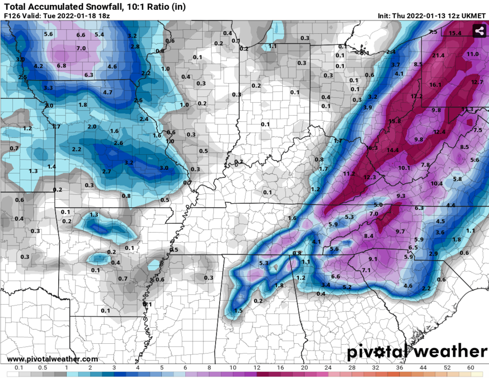
I’ll take that 4.1 inches and call it a day
-
2
-
-
1 hour ago, Carvers Gap said:
And turn out the lights in the rest of the Valley - major ice storm.
Just say no to ICE kids!
-
1
-
-
2 minutes ago, Holston_River_Rambler said:
A few more 15z SREF members see snow in Crossville than at 9z. I guess that's something.

-
3
-
1
-
-
9 minutes ago, John1122 said:
I don't even know what to say about the 06z GFS. The low travels NE from the ArkLaTex to NE Miss, drops SSE to Central Alabama, jumps way back NW to West Tennessee, bombs to 999 north of Nashville then hands off to SE NC. It would be the weirdest surface track in the history of a Winter Storm.
Yep, I’ve never seen anything even remotely close to tracking like that, looks like it will be several interesting days watching models. I’m with @unclenasty a miller b is bad news for the valley!
-
2
-
-
Well I’m gonna head back over to

after that run!
-
NWS getting onboard:
Wednesday Night through Friday

At the start of the extended period, a mid/upper shortwave will be
diving out of the northern CONUS with surface high pressure receding
to the east. The passage of this shortwave will provide increasing
PoPs into the day on Thursday and Thursday night via increased
vertical motion and a more W/NW flow pattern near the 850mb level.
Recent model runs continue to suggest a more saturated column, even
in the lower elevations with 1,000-500mb thickness values falling
below 5,400 meters area-wide. As such, this will justify a continued
expansion of PoPs into the region with orographic considerations
suggesting increasing potential of accumulations in the higher
terrain. As of yet, low-level WAA during the daytime on Thursday
looks to keep the boundary layer largely too warm in the lower
elevations for much of the region to transition to snow before
moisture exits. Nevertheless, potential does exist for evaporative
cooling to help transition at the surface even in the lower
elevations. With continued N/NW flow and sufficient low-level
moisture into Friday, PoPs will be lingered during this timeframe.
Overall, the pattern does not suggest too ideal of a NW flow setup,
but light accumulations in the higher terrain at a minimum are
increasingly likely. Heading into the weekend, focus turns towards a
shortwave and developing system out of the Great Plains via
cyclogenesis.

Saturday through Tuesday

The aforementioned developing system will be the feature of focus
during the weekend with potential for significant impacts in
portions of the eastern CONUS. Much of the uncertainty lies with the
evolution of the upper pattern as well as the the track of the
surface low. Based on the latest GEFS mean, GFS, and ECMWF
deterministic runs, the upper-level pattern and surface low track do
support potential for widespread accumulating significant snowfall
across the region. It is important to note that, as we have seen
with recent snowfall events, a change in the track or evolution of
the system can make or break potential for snowfall in the area
based on downsloping and other factors. However, with the ensemble
and deterministic consensus with these model runs, confidence has
increased sufficiently for HWO wording to mention this potential. It
is also important to note that, depending on how the pattern evolves
850mb moisture and flow may be more favorable for northwest flow
snowfall in the mountains even beyond the day on Sunday. Beyond the
weekend, the pattern looks to be more settled, but below normal
temperatures could allow for any snowfall that does occur to linger.
-
2
-
-
The Jinx is happening, TWC has now placed 1-3 inches for Athens Saturday

-
 1
1
-
-
30 minutes ago, Holston_River_Rambler said:
12z EPS low clusters:

I’ll take a developing intensifying low off the Florida panhandle for $1000 Alex.
-
2
-
-
5 minutes ago, Wurbus said:
Lots of big DAWGS (GA fan, couldn't resist) on there for someone. Should be an interesting week ahead of us again!
Oh yes, the wife is a huge Dawgs fan, you would have thought it was the second coming of Christ when she knew they were gonna be National Champs!

-
1
-
-
I haven’t seen things this Active since my X-Wife slept with her co-workers! Keep ‘em coming!
-
3
-
9
-
-
4 minutes ago, Carvers Gap said:
The 12z Euro has initialized.......

-
7
-
-
84/85 Winter
-
3
-
-
Here ya go I thought I had the year right, school was out for 17 days!
-
1
-
-
1 minute ago, Mr. Kevin said:
I was only 5 at the time but from what I understand, it was really cold and stormy. That winter had a pv split and this winter has stretching of the pv at times.
Correct! @Carvers Gapcorrect me if I’m wrong but I remember an epic ice storm in that time frame as well!
-
1
-
-
13 minutes ago, Carvers Gap said:
Yep, models are definitely honking, and so are analog packages and the MJO to some extent. Obviously, nothing is a certainty, but very strong hints for sure. The 18z GFS took TRI below freezing at 294 and didn't get back above freezing until 384. Couple of days with highs in the teens. The GFS has been very cold in the LR. Ensembles 500mb patterns would allow for cold to get pretty far south. Seeing 93-94 and 95-96 show up in analog packages today. @John1122There is 1994 in the analog package. It was in the 6-10 as well.

Boy do I remember 84/85, the coldest I’ve ever been and it’s not very hard to remember since we were poor as heck and only had a Outhouse! Trust me -20f and a outhouse you’ll never forget it!
-
1
-
1
-
-
6 minutes ago, McMinnWx said:
Cold drizzle here. Losing hope that any winter precip is headed this way.
Agreed, I’m taking a Nap lol
-
4 minutes ago, ShawnEastTN said:
Just started going back to snow, warm nose must be exiting the western great valley.
Sent from my SM-G965U using Tapatalk
Swing that about 15 or 20 miles this way
-
1
-
-
15 minutes ago, RawCrabMeat said:
How's everyone enjoying their stay in warm nose cemetary
-
3
-


Jan 16-17th Boom or Bust
in Tennessee Valley
Posted
I’m sorry but is that a P……