
WSchew
-
Posts
72 -
Joined
-
Last visited
Content Type
Profiles
Blogs
Forums
American Weather
Media Demo
Store
Gallery
Posts posted by WSchew
-
-
Radar is drying out a bit upstream and looking less hectic overall. This should end any snow/sleet in the triad as the moisture becomes more shallow.
-
So I’m noticing that my temp is falling a couple degrees faster than most of the hi-res guidance, even accounting for the earlier onset of precip than what was shown. Even the NAM is a degree too warm. I’m wondering if that since the models are showing rain, but we’re actually seeing lots of frozen precip at the surface; that the models are slow to cool because they aren’t accounting for atmospheric heat being removed to melt the snow/sleet.
-
And there it goes right back to mostly sleet. We seem to be near isothermal with these quick flip-flops, very rate dependent.
-
Mostly snow west side of Winston, very few small rain drops, sleet has stopped. 34/31
-
34 minutes ago, FallsLake said:
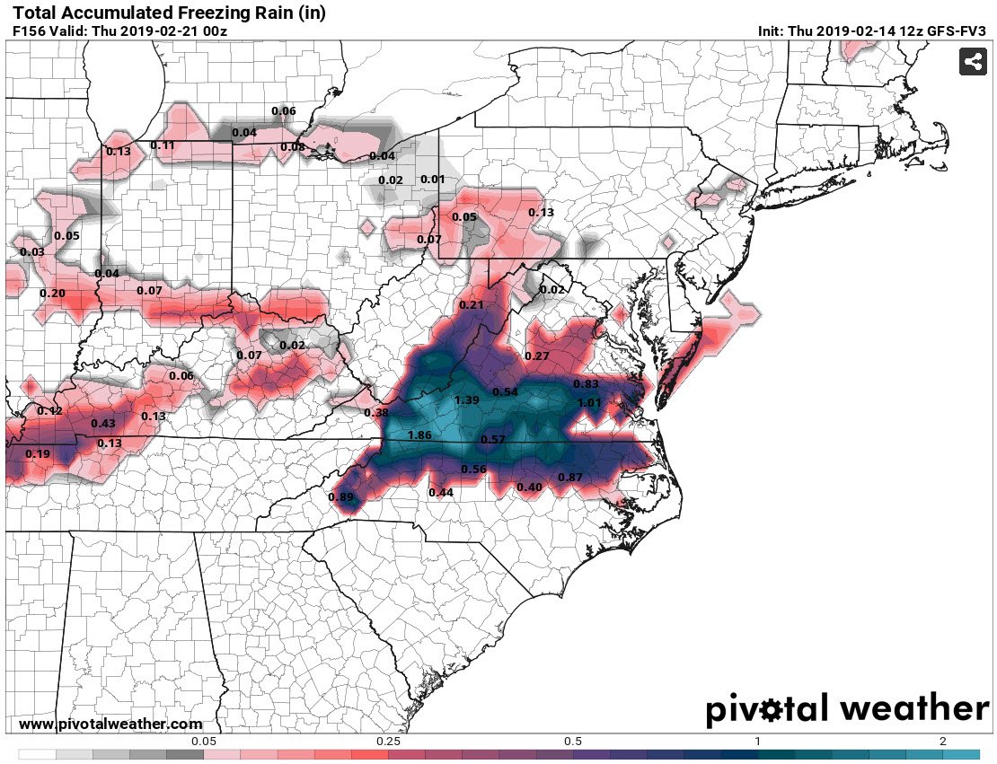
The 12z FV3 did come in a little colder for next weeks potential event. Would be significant ice for our region. But, I agree it hasn't done well lately.
Freezing rain totals:

FV3 is the cold outlier. Imagine that...
-
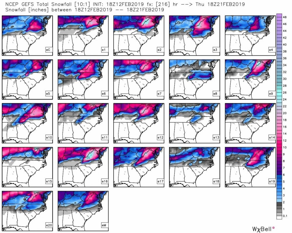
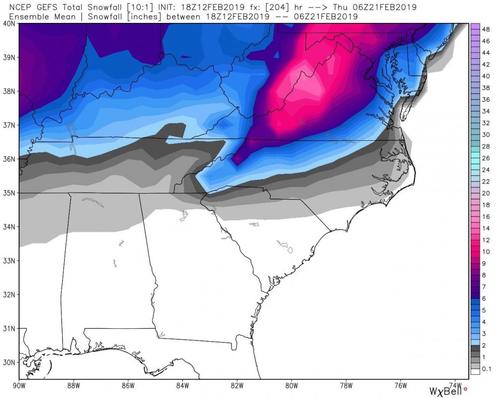
Really good look from the GEFS if you’re in WNC.
-
 2
2
-
-
0z Canada lost it for now. It’s showing apps runner on Monday with a little ice in NC mtns up thru most of VA, cold rain from Wilkes Co and points SE. CMC also showing warmer solution for second system on Wednesday with rain all the way into WV mtns, snow confined to PA.
-
Someone please drop some ensemble maps in lieu of the clowns above.
-
Looks to be two systems around 2/19-2/22. The first one could *potentially* establish lower heights, allow HP to build over NE and leave a frontal boundary in the gulf. System 2 develops along the boundary then we have miller A vs. B. What could wrong?
-
FV3 continues it’s med range cold wedge bias. It has a similar precip setup next Tues, but the HP is much weaker at onset (1038 vs 1026-ish). Regular ol’ GFS has something there too, more of a slider look but with cold air trying to ooze over the mts rather than a CAD signature.
-
0z FV GFS lost the icy look in NC Piedmont Sunday afternoon 2/10, but it’s back at 6z. Also, it has been wicked consistent in showing something next weekend for a few days now. GFS and CMC are not enthused, however.
-
A little, but in the form of high clouds. No precip
-
HRRR removes heat fast this evening. It takes 2m temp in the triad to 32 around 5pm - down to 24 at 7 pm. It bottoms out in the mid teens in NC Piedmont where there’s a nice snowpack. This seems a bit overdone based on forecasts.
Hi res NAM is much warmer and slower to radiate. Doesn’t drop to freezing until midnight, bottoming out in the mid 20s in northern NC, tapering to 32 towards SC line. This seems warm even if the clouds are stubborn.
RGEM is somewhere in between the two and seems most reasonable. Drops to 32 between 6-7pm, bottoming out pretty close to everyones official forecast low.


February 2019 Observations
in Southeastern States
Posted
Huge flash and clap of thunder just to my west even with the wedge locked in... 33/32 all day long.