

BTRWx's Thanks Giving
-
Posts
3,332 -
Joined
-
Last visited
Content Type
Profiles
Blogs
Forums
American Weather
Media Demo
Store
Gallery
Everything posted by BTRWx's Thanks Giving
-
That clustering has a lot of white space.
-
That would be rain.
-
Just a random comment, the new para gfs looks very similar to the euro throughout the run!
-
Really cool idea!
-
Three weeks of snow for sure.
-

November Medium/Long Range Discussion
BTRWx's Thanks Giving replied to WinterWxLuvr's topic in Mid Atlantic
Southerners unite! -
The long range eps is uuuugly.
-
Didn't lwx already forecast for them? It looks to me like Pittsburgh is being removed for them.
-
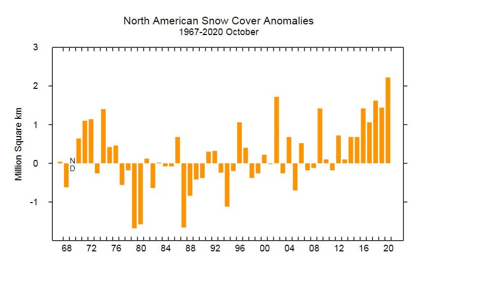
This is an interesting chart posted from Perspecta showing record snowfall across North America in October! Also notice other years with high values. What I find strange is most high values seem to be ninos.
-
The NAO is also trending worse. This time of year that's really bad for us.
-
All things considered, this is not a bad comparison! Two great snow seasons
-
I'm really struggling to find analogs for a nina that had low heights over the northern plains along with above normal heights over northeast Pacific in October. Also, Europe tends to be above normal.
-
The was the greatest end to a World Series game!
-
Here is a good simulation of how the GEFS has trended west overtime with the cooler weather.
-
How strong is this nina supposed to be?
-
I would much rather have a warm October for winter's purposes.
-
This is pretty far out, but it's looking more like October won't be so chilly after all!
-
2011 to 2013 came close.
-
70 years of data is not unreliable. I don't appreciate you always criticizing my work.
-
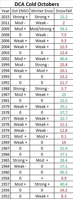
Since 1950, only one cold October weak nina year had slightly above average snowfall at DCA. Most decent winters with cold Octobers were ninos.
-
Our last October trace on snow was 2011-2012. Cold Octobers are bad for our winter.
-
That was me last year.
-
More support for a crappy winter
-
Bastardi hinted at favoring a northern Plains winter.
-
January 2020 Mid/Long Term Discussion
BTRWx's Thanks Giving replied to nj2va's topic in Mid Atlantic
Maybe she'll do a mini loop back into phase 8 for mid February. I'm not saying that I think that will happen, but think it's possible.

