

Waiting on snow
-
Posts
406 -
Joined
-
Last visited
Content Type
Profiles
Blogs
Forums
American Weather
Media Demo
Store
Gallery
Posts posted by Waiting on snow
-
-
2 minutes ago, CentralNC said:
I am thinking North.
Good call!
-
By this time tomorrow we close in on 100 hrs of the event. One would think the ensembles and the operationals will begin some agreement. Will the ensembles go north? Or will the ops come back south? I know what my money is on

-
 1
1
-
-
21 minutes ago, No snow for you said:
I think I’m going to stay here a couple of more days. Burns keep the tab going.
I think I'll join you.The storm thread doesn't need my negativity at the moment. They are already on the edge of the cliff and for good reason outside the mountains and Virginia.
-
1 hour ago, SnowDawg said:
Just can’t never get a high to lock in throughout a storm anymore... Always rocketing off the coast as soon as the precip arrives.
You can thank the NAO and its positive state for the better part of a decade for that. People blow it off and say the PNA is more important. Truth is they are equally important. The PNA delivers the cold but the NAO slows it down and locks it in. Without it you're trying to get the low and high to run in tandem and well, you know that fails 9 out of 10 times.
-
 3
3
-
-
54 minutes ago, SnowNiner said:
At this long lead, I wonder why the NWS doesn't lean more heavily on ensembles. They seem to base their forecast on guidance from operational models in their discussion.
I've wondered the same. Seems pro Mets preach ensembles but hug and flip flop with op runs. I think they go with the warmest least snowy regardless if its the ensembles or the ops. Smart call most likely.
-
1
-
-
13 minutes ago, jjwxman said:
12z EPS: You really can't ask for much more than this at this stage in the game. Roll on!

I'm not one to be very optimistic about winter weather because if there is a way to screw it up we will. That said there is no way the Euro op is even close to correct if its ensembles are even close. That has big boy written all over it for the majority of the board!
-
43 minutes ago, Orangeburgwx said:
You have no idea how bad I needed that laughing fit I just had after reading that... Thank you

I feel for ya Orangeburg. I know the pain from when I lived around CAE. But Orangeburg is the spot to be for the afternoon storms all summer long. You've got that over the rest of us!!
-
1
-
-
37 minutes ago, gearhead302 said:
And now the wheels come off. This is precisely why you don't hype a snow event in SC 6 days out. The north/warm trend is always inevitable
Orangeburg never had wheels to come off! He's been on jack stands the whole time!!!!
-
3
-
 5
5
-
-
2 hours ago, Orangeburgwx said:
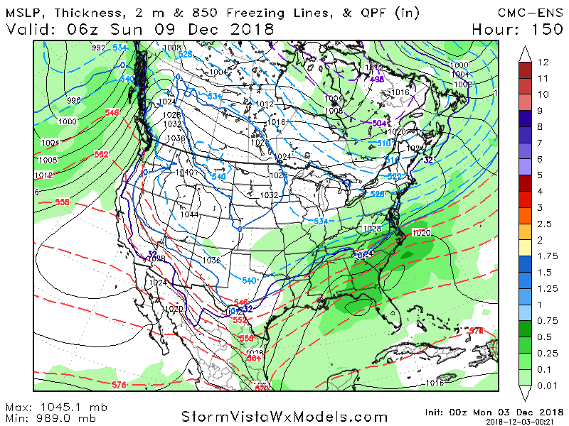
.LONG TERM /WEDNESDAY THROUGH SUNDAY/...
Surface high pressure will remain across the region Wednesday into
Friday morning, with another cold front then moving into
through the area Friday afternoon, and pushing well south of the
cwa into Saturday. Dry conditions will continue into Friday.
The chance for precipitations will return Friday night as
moisture overruns the frontal boundary stalled to our south.

The main concern in the long term is the potential for a winter
mix over the Piedmont and north Midlands Saturday into Sunday.
Confidence is low at this time as to the location and amount of
winter weather given models differences.

Models develop an area of low pressure along the frontal
boundary to our south. The ECMWF has the area low pressure
farther south than the GFS...thus allowing colder air and the
chance for winter weather to possibly affect the northern
Midlands and Piedmont Saturday morning as temperatures fall into
the mid 30s and again Saturday night as lows dip into the low
and mid 30s. This cold and wet pattern is expected to continue
into Sunday as the area of low pressure crosses the southeastern
states and moves off the Carolina coast. Confidence remains low
and much can change between now and then, so will continue to
monitor through the week.
Come on NWS drop the hammer and tell the truth...
Looks like they did tell the truth. Unless you mean drop the hammer and remove winter precip all together?
-
5 minutes ago, jjwxman said:
FWIW the 6z GEFS had several members jump north, although the mean still looks further south.

Of course. I have a feeling this is the beginning of the end for the upstate and CLT to RDU folks. I hope I'm wrong. But it's a little early to be starting the inevitable nw trend.
-
 1
1
-
-
9 minutes ago, griteater said:
Said I wasn't going to stay up, yet here I am. Here's the CMC ENS Mean. More Miller A-ish than its Op run
Yep ensembles at this range. I know that as well as any. But hard not to get worried over op runs that trend wrong because we all know we don't get the type of storm that was modeled in these parts. We just sit back and wait for the wheels to fall off with each model run.
-
2
-
-
13 minutes ago, mackerel_sky said:
Go with the latter! This week just got a lot more productive at work! Won’t have to watch this dumpster fire anymore!! Somebody post the clown maps!

Yep that fell apart quickly. Historic to nothing in one run. Smdh
-
 1
1
-
1
-
-
Just now, WidreMann said:
00z GFS is also further north and a little warmer. Might be the beginning of the end.
Yep the sanitarium will fill up quickly.
-
2
-
-
1 minute ago, griteater said:
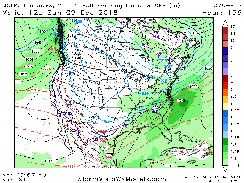
00z CMC is north. Major winter storm for WNC into VA. Verbatim it has dual sfc lows in E TN and E SC
And so it begins.
-
1
-
-
3 minutes ago, Suncat said:
I've put on my running shoes so I can build up some speed before making my leap off the cliff. I want to be sure to be in front of the pack!
Don't worry it is coming. No possible way these models hold this scenario for 5-6 more days.
-
1
-
-
3 minutes ago, mackerel_sky said:
What’s the next model up? Doesn’t Ukie or CMC or Icon, come out before GFS?
Don't rush it! I'm enjoying the moment because it's only a matter of time before it goes to s**t
-
2
-
-
31 minutes ago, wxdawg10 said:
I've seen this story play out so many times..model hug at your own peril. Southeast climo is a beast and more often than not, it wins out. it's nice to have a storm to track but models are poor getting a handle on these storms 3+ days out. I do believe somebody is gonna get crushed but who? it's toss up at this point.
Yes climo is a beast. Gonna be a lot of disappointed people if they model hug. The south trend will cease and the nw jog will commence in a day or two. Then once we get within 72 hrs the totals will come down to realistic totals. Climo favored areas north of 85 in SC and NC would be my guess at this point. And a few inches at max.
-
3
-
-
31 minutes ago, Queencitywx said:
You're right. People are acting like we've got this thing in the boat and I dont get itn frankly, I've lost dozens of storms in this time frame over the years.
Exactly! At 6 days out I don't see how anyone can say this is a slam dunk. Maybe this is in fact different with such a strong signal. But I personally will hold off on my excitement.
-
1
-
-
4 minutes ago, calculus1 said:
Who knows how all these algorithms actually process the information to produce these "snow" maps? But, IMO, the only part of SC that has any realistic shot at snowfall would be the upstate, like usual. And none of us, NC and VA included, should get too hyped at this point. I love all the trends and the signals, but this is early in the season and still so far out that we can't accurately predict anything with any confidence. Let's keep it all in moderation, guys, and not get too insane with our posts. I so appreciate the sound, reasonable meteorology, but I could do without the crazy, unfounded gut feelings.
Sent from my Alcatel 6055U using Tapatalk
I understand it takes all frozen at 10:1 and shows snow. But SC doesn't even get freezing rain by the exact same model.
-
1 hour ago, packfan98 said:
Yep! The low tracked pretty much due east instead of cutting. Many ensembles have had a similar look. Here's the overblown clown map:

How does it come up with that in SC? By tropical tidbits SC sees rain the whole time.
-
1 hour ago, Waiting on snow said:
It's time for the FV3 to get on board and prove it's way better than the garbage GFS we are used to.
And right on schedule it joins the party!
-
It's time for the FV3 to get on board and prove it's way better than the garbage GFS we are used to.
-
1
-
-
39 minutes ago, Buckethead said:
I lived in Southern Lexington County for 25 years. Hoping for winter weather down there (especially this early) is a recipe for ulcers. I feel your pain, Oburg.
Definitely! But always close enough to the action to be excited but 99% of the time you'll be banging your head against the wall when it's over!
-
11 minutes ago, Orangeburgwx said:
Not going to give up until the day of
Hope you have a prescription of xanax handy for winter then. Gonna be a long one for ya. After living in CAE for 5 years and Orangeburg being further se I'd keep my expectations very low.
-
1
-
1
-
1
-
December 8-10, 2018 Winter Storm
in Southeastern States
Posted
Now you're being realistic! Hell I'm in the extreme nw corner of SC and I have one foot over the cliff.