

StormChazer
-
Posts
1,089 -
Joined
-
Last visited
Content Type
Profiles
Blogs
Forums
American Weather
Media Demo
Store
Gallery
Posts posted by StormChazer
-
-
3 minutes ago, GSwizzle83 said:
EURO puts down a lot of ice on the 00z run as well. Should be an interesting week of tracking. Moderating temps will make conditions tricky, but will have more moisture to work with.
Can you link or post that? Thanks!
-
12Z Canadian came in with alot more oomph.


-
These are a few of my personal favorites. I know its over a week out but I need something to look forward to!


-
Oh, sorry, 12th-14th.
-
There's a pretty decent number of members from the Euro showing quite a dumping of snow over the OK,AR,MO,KS, etc, area. I'd say a little over half the members show a widespread snow event, with 6+ inches.
-
7 minutes ago, MUWX said:
The Canadian is the only one showing this, correct? Every other model seems much less bullish to me.
Yeah, the GFS still shows something similar, just not as heavy or widespread, same with the NAM and WRF.


-
The Canadian really wants to put a patch of moderate freezing drizzle/mix over Eastern OK/Western AR. The way temps have been, and the temp it will be when that comes around, anything that falls will immediately stick and begin to accumulate.

-
I would hate to see all this cold air go to waste....
I'd be so happy with 3 inches that stick around for a few days. Looks like this next system I'll have to be happy with an inch, although there's a lot of time between now and Sunday. -
Any thoughts on this potential storm this upcoming week? Doesn’t seem like models can get a consensus.
-
42 minutes ago, The Waterboy said:
Where are you located?
I was at work off 21st and Lewis in Tulsa.
-
I noticed the trees here are now collecting frozen droplets.
-
4 minutes ago, GSwizzle83 said:
NWS SGF Facebook live said Tulsa is in the process of issuing a WWA.
Good to know, thanks! Tulsa just updated their site as well to indicate 1-3 inches now, instead of 1-2.
-
8 minutes ago, MUWX said:
Sgf pulled the trigger on a WWA and went with ~3 inches along the I44 corridor. Seems like a good bet to me, most models seem to be locking in on that solution. We still need to watch temps and see if they fall faster than anticipated. Monett has been locked in at 34 for quite some time now. Airport dropped to 32 earlier, but I'm not sure they was accurate
I've got to think based off OKC and SGF that we will see Tulsa fill in the gap on the advisory around 5 PM today.
-
30 minutes ago, MUWX said:
Thank you.
These temps seem to be falling a bit faster than I think was predicted. I've heard from co-workers there's already some sleet and freezing drizzle falling in Cushing and starting in Sand Springs. -
2 minutes ago, MUWX said:
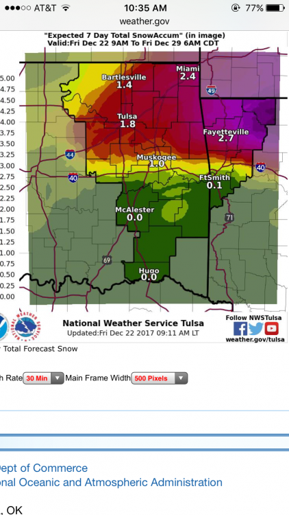
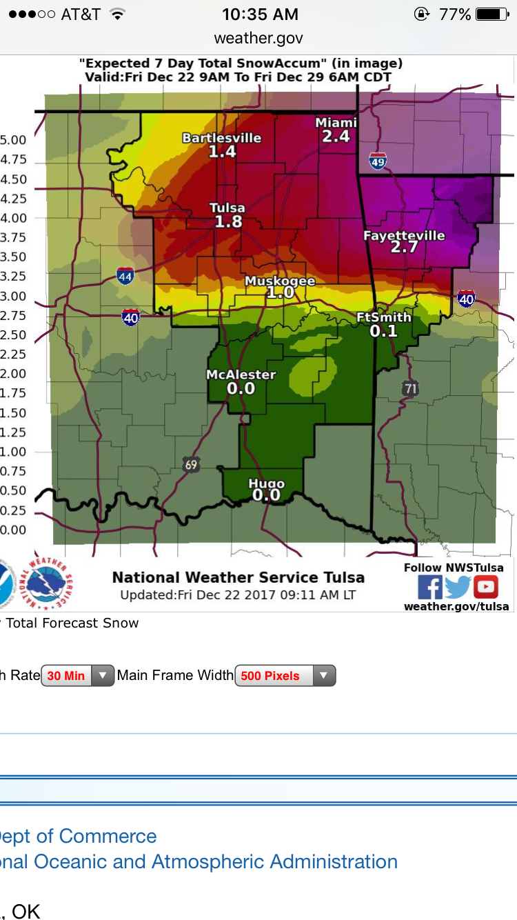
This is their 24 hour snow total, but their 7 day snow total has amounts of about half this. Not sure what the disconnect is.
Can you link me to this? I'm having trouble finding it on their page.
I'm interested to see if they are saying 1-2 because they don't want to say double that just yet, or if they don't believe this because it's based off something they don't trust with certainty. -
Looks like Tulsa finally bought in.
"As main vort max moves into northeast Oklahoma tonight, precipitation
is expected to transition to snow by late evening into the overnight
hours across northeast Oklahoma and northwest Arkansas. Snow accumulations
of 1 to 2 inches will be possible near the Interstate 44 corridor and
in the higher terrain areas of northwest Arkansas before precip shifts
east Saturday morning. Still some significant uncertainty regarding
how quickly precipitation transitions to snow tonight and overall
amounts. Also, depending on how quickly the heavier precipitation
spreads north of the front today, there is some potential for
freezing rain or freezing drizzle if temperatures can wet bulb
below freezing. A winter weather advisory may be need for portions
of northeast Oklahoma and northwest Arkansas as precip type/amounts
become more certain."
Last night they were showing 1/4th an in of snow, now it's 1-2. Confidence in how quickly the transition takes place seems low to me. That could affect amounts as well.
-
It's still slowly moving towards the Canadian and NAM though.
-
That's the thing about these types of situations, they're either a total bust, or someone winds up with waaayy more snow than forecasters called for. I'm not jealous of the meteorologist who makes that call. I'd rather promise little amounts and get more, than call for lots and get little to none.
-
2 minutes ago, The Waterboy said:
Tulsa AFD not biting on the 18z NAM. Would love for them to be wrong.
A brief window of wintry precip remains likely late Friday night
through early Saturday along the western periphery of the precip
shield. Sfc temps will not be overly cold behind this initial
frontal passage and precip intensity will be diminishing with
time. Also precip type will likely be highly variable with the
expectation that sleet or light snow will dominate the longest.
Both icing and sleet / snow accumulations are forecast to remain
light and any impacts likely confined to elevated road surfaces.
The 18z NAM may receive some attention for those hoping for more
snow however it remains a large outlier and related SREF trends
are not optimistic for such a large forecast adjustment.
Well the GFS is starting to pick up on something as well. It used to have zero in the way of snowfall, but now we have a small swath of around an inch. Curious to see what the next sets have to say. I don't think they can discount it if they all start converging.
-
28 minutes ago, Weatherdemon said:
18z NAM saying the same thing.
So the NAM and the Canadian seem to think that upper level low is going to kick up some measurable snow. Anyone know what the latest Euro shows? I know the GFS is saying it's a no go.

-
I'll have what the NAM 12K is having please.....

-
The NAM 3k does show some light snow as well.

-
I would love for the Canadian to pull this one out for us....
-
49 minutes ago, ouamber said:
Lol just 2 days ago, Kansas was getting buried, and now today Texas is getting buried. Do you want to be in the Euro and GFS sweet spot 10+ days out? I like spread the wealth storms though...hoping we all can cash in on this.

Yeah, I'd like to think we are in the sweet spot right now. We've seen both sides of the spectrum and we are smack dab in the middle, so here's to hoping for some snow.
-
 1
1
-


MO/KS/AR/OK 2019-2020 Winter Wonderland Discussion
in Central/Western States
Posted
The Euro definitely is our friend right now in this situation. Looks like the Euro and Canadian feel there will be some colder air in place, but also set up a potential icy situation for many. Meanwhile, the latest run of the GFS pushed the storm even further north. Here's to hoping that was an outlier and the next run begins to look more like the others.