

StormChazer
-
Posts
1,089 -
Joined
-
Last visited
Content Type
Profiles
Blogs
Forums
American Weather
Media Demo
Store
Gallery
Posts posted by StormChazer
-
-
My attention has officially been had.
-
Might get a nice little dumping of snow this Sunday. We shall see!
-
1 hour ago, MUWX said:
As I understand it from reading their twitter replies, they were allowed to issue Winter Storm Warnings for ice rather than having to issue Ice Storm Warnings. Their Ice Storm warnings are now being used when they expect significant infrastructure (power grid) impacts, while Winter Storm Warnings are used when the ice is "only" expected to cause major travel impacts.
Here in SWMO, I figured we would have little to no issues with the power grid because air temps were pretty borderline for the entire event so most of it would not accrete on elevated surfaces. However, due to very cold ground temps, roads were super vulnerable. However, SGF does not have the ability to issue a Winter Storm Warning for Ice, so they had to decide between the advisory and an Ice Storm Warning. Based on travel impacts, I think today absolutely should have been a Winter Storm Warning, but offices are limited by the the definitions laid out.
Wow, I actually had no idea about all of that. Thanks for the info!
-
It’s almost 5:30 and it’s still not above freezing here in Tulsa.roads are still awful.
-
5 hours ago, MUWX said:
I like what Tulsa did with the winter storm warning. From what I understand, not every office is allowed to do what they did because it’s in the trial phase but this absolutely should have been a WSW in SWMO. I haven’t seen travel impacts like this in a long time.
Can you explain what they did?
-
Tulsa got upgraded to a warning overnight. We have quite a bit of ice at my house. The freezing rain has been steady almost all night.
-
I can confirm that roads are glazed over already here in Owasso, northern side of Tulsa.
-
 1
1
-
-
Heavier ice totals shifted to the north along I44 this run in the NAM. Gives Tulsa .40 inches, enough for warning criteria.
-
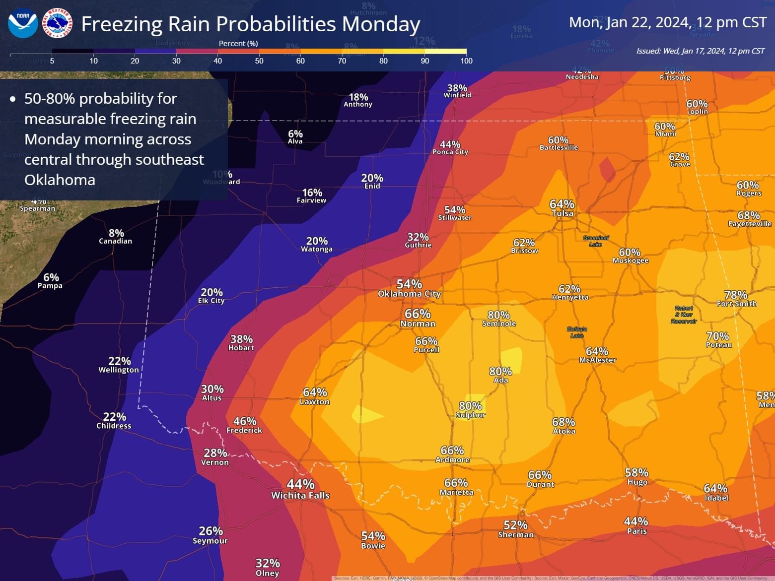
9 hours ago, OKTWISTER said:

Updated
http://www.weather.gov/images/oun/graphicast/image1.png?a44dc7f95325dce9b8a06b4b1f9a045c
-

Waiting for Tulsa to put something out.
-
Ice storm a week out?
-
1
-
-
I don’t have an official measurement, but I think we got around 2.5 inches here north of Tulsa.
-
2
-
-
55 minutes ago, The Waterboy said:
Well, it seems that apathy and numbness are setting in with most of us, me included.
Does anyone have a good pregame speech to rally the team???Winter weather advisories are out and some upgrades to Winter Storm Warnings.
Ladies and gentlemen,
Never forget, Mother Nature is at her core, unpredictable. Some of the most memorable weather events in history happened because things did not go as intended and Mother Nature had her own plans.
I’ve experienced several winter weather events that were like a dream all because a storm overperformed.
As far as we have come, our knowledge is not infallible.
There is low confidence in this storm, which means the likelihood of someone getting more than they bargained for is higher.
I believe the storm will give us more than advertised! A band will set up somewhere and drop half a foot. Mark my words!
-
4
-
-
I’m ok knowing that 4 is still on the table if I’m lucky, otherwise 2-3 seems like a solid bet as of right now.
Honestly, I’ll take it.
-
The euro ends the trend of being completely dry and juices that first wave up some. Roughly 2-4 inches for most of us here.
-
GFS roughly the same as last run.
It's becoming clear though, that it all depends on how strong and the orientation of the initial wave of snow, that will determined 95% of the snow we get here.
So, do we underperfom or overperform?

-
1
-
-
I place my hope in the NAM.
00Z

-
1
-
-
GFS has forsaken us. Still not bad. I really just want 4 inches out of this.

-
Latest NAM.

-
1
-
-
Recent runs to see if we can identify a consensus or trend.
12Z GFS(Sticking to it's guns)

12Z Canadian(Much improved over last night's run)

12Z ICON(Double these amounts. An Improvement over this morning and last night's runs)

06Z Euro(Still disrespectful)

12Z NAM(Still second wave coming)

Final thoughts.
A better trend than last night.
The GFS and NAM seem to be thinking similarly.
The Canadian pulled back from the Euro and looks similar to the ICON
The ICON is a halfway point between the EURO and GFS.
The Euro is all alone.
Overall, I'm happy with this trend compared to where it was going last night.
Not surprised the 06Z Euro looks about the same as last night given it's using the exact same upper air data as the 00Z.
This afternoon's run will be very telling. I hope the Euro caves on it's stubborn, ugly output and falls somewhere in between the GFS/NAM and the ICON/Canadian.
-
2
-
-
I’m fine with the latest NAM solution, wave 2 is coming in but not yet shown on.
-
1
-
-
KING GFS! That’s a thing right?
I don’t care, I’m shouting it from the rooftops, GFS I feel has been very reliable thus far and the most consistent.
I really just want at least 4 inches. I don’t NEED 8, I just want it really bad. But 4+ keeps me happy.
2 or less makes me sad.
waiting on the NAM.
-
 1
1
-
-
Furthest out the NAM goes, with still alot of storm left to go. Of course hour 84 NAM isn't exactly gospel.
Also, we have a great lightning show going on here in Tulsa right now.

-
Norman put this out earlier. They don't seem to be totally biting on the Euro change.

MO/KS/AR/OK 2023-2024 Winter Discussion
in Central/Western States
Posted
Tulsa going extremely conservative with their amounts.