
PowderBeard
-
Posts
1,961 -
Joined
-
Last visited
Content Type
Profiles
Blogs
Forums
American Weather
Media Demo
Store
Gallery
Posts posted by PowderBeard
-
-
17 minutes ago, OceanStWx said:
This event really seems to have the hallmarks of a lateral quasi-stationary (think parallel) band transitioning to a pivot. The orientation of that departing equatorward jet streak was definitely more SW/NE than WNW/ESE, which tends to promote that parallel band riding along storm track. That's what I think it pumping our highest totals up over a foot, pushing 18", vs a more uniform 6-10" followed by the pivot.
"The ribbon" that most hi-res models were showing?
-
20 minutes ago, Lava Rock said:
Frick, looking at my home cam I figured we got ~6" since I cleared this morning, so was expecting ~12", but based on your local to mine, could be similar. Although we get suckered sometimes on the hill. Will find out soon enough.
There were two short breaks from about 8-9am and 11:30 - 12:30 here. I figured light to moderate snow this afternoon and evening but it has been some of the heaviest of the day, other than that 2.25" from 10-11am. We have got about 11" from when I cleared around 6:30 this morning.
-
1 hour ago, Lava Rock said:
what are you up to now? I'm still at work, but anxious to get home to measure and snowblow again.
2.5" more in the past hour. Just over 15". The "weather station" at our kiddo's school in New Gloucester was at 16".
-
 3
3
-
-
Nuking again. Lollis to 15-16" incoming.
-
3
-
-
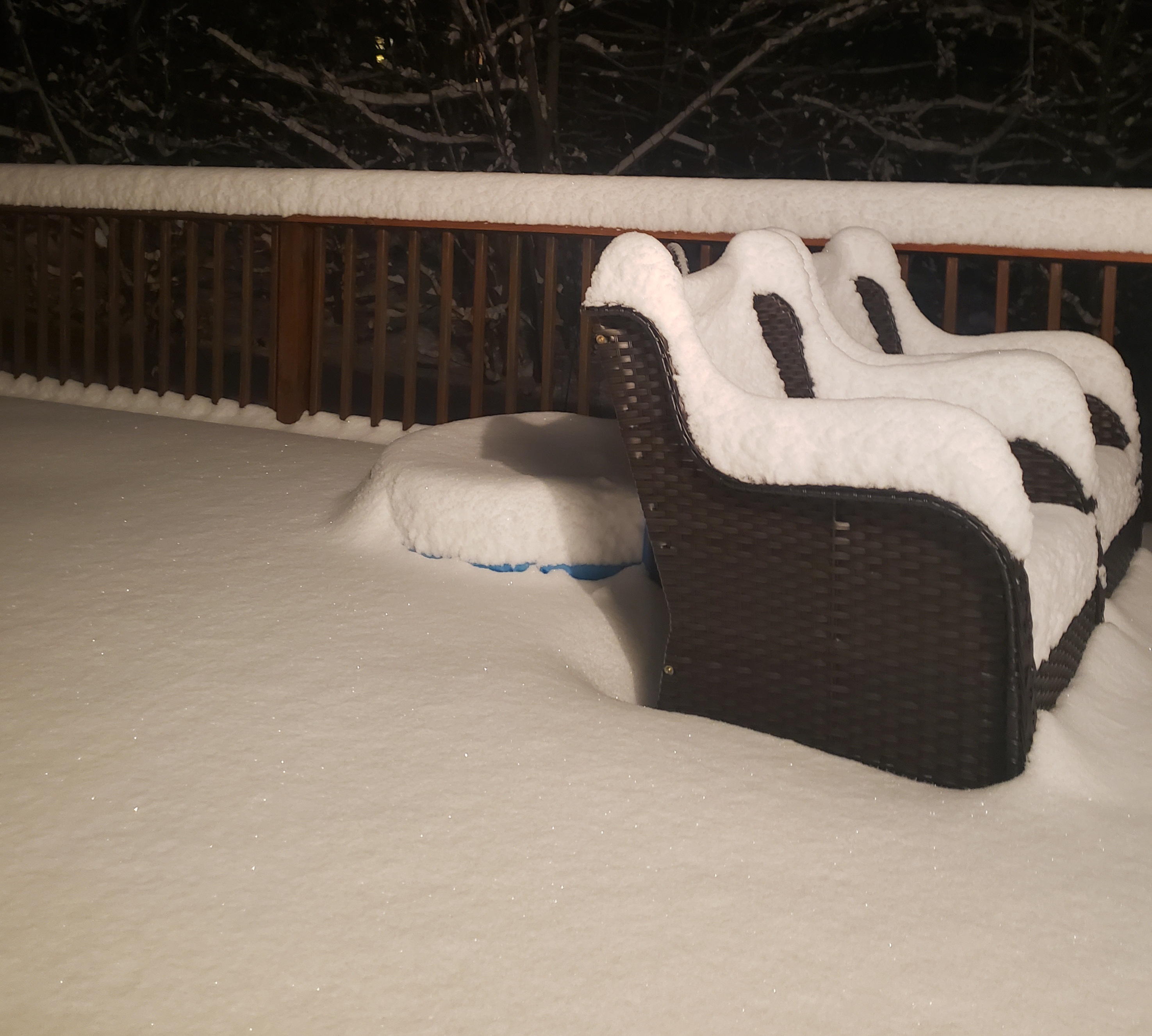
We buried. Over 12" for today so far.

-
11
-
-
The lull did not last long, filled right in. We are back to heavy snow and closing in on 12".
-
4
-
-
14 minutes ago, mahk_webstah said:
looks like we both might be missing a big band to our west shortly. is that subsidence? If so, I'm content with almost 11"
You were right about that last band. We had just over 2.25" in the last hour.
-
2
-
-
7 minutes ago, tunafish said:
Looks like the last push before we slot

Tapering down up here but still moderate snow. HRRR and NAM 3KM showed that bit of a mid-day lull but got things going again in mid afternoon into early evening. I'm thinking another 2-4" here.
-
1
-
-
18 minutes ago, dryslot said:
Not yet, Some of its a bit south but behind that one yes
 16 minutes ago, mahk_webstah said:
I hope you get it man. It had slowed to like an inch an hour, but now it is just pounding again. And whatever I get will hit you for an additional couple of hours.
We are getting into it now. The heaviest stuff I have seen in a couple seasons, wind is picking up and driving it hard.
-
3
-
-
Black was awesome yesterday. Most woods are open. I'd say 75% of the woods and 25% of ungroomed trails still had 6-8" of untracked in them from Friday. Definitely a special place. Kiddo is finally big enough for the "pack" if she wears an oversized snow suit and I couple of other adjustments. It allowed for some serious progressing and I was able to let her go free a couple of times. Im also sadly realizing the days of her skiing between my skis are over.

-
1
-
-
15 minutes ago, mahk_webstah said:
2.5" past hour, 9 total.

-
1
-
 2
2
-
-
Just measured 8.5" with about 4" since 6:30am. Most of that 4" has come down since 9am.
-
1
-
-
14 minutes ago, PowderBeard said:
When it went through here is seemed like really high density stuff and piled up quickly.
Pounding here again. Looking at the HRRR and NAM it looks like we could break 12"?
-
3 minutes ago, dryslot said:
Ripping some large dendrites right now, This is some very good snow growth.

When it went through here is seemed like really high density stuff and piled up quickly.
-
We had a lull from about 7:45 until 10 minutes ago. Getting crushed right now, looks like 2+ an hour rates and 30+ dbz on radar. Just measured 7" on the dot.
-
1
-
-
Measured about 4.5" at 6:30, cleared the driveway for the neighbors and already covered in about 2" again. Wind is starting to crank now. I just went to the gas station and there was traffic stopped in a few places due to visibility, definitely less than 100 yards at times.
-
2
-
-
Pounding sand here.
-
Interesting radar look with a heavy band from North Conway to the NE and a big hole from Lewiston to Augusta.
-
27 and mood flakes.
-
1
-
-
2 minutes ago, Lava Rock said:
First flakes
Sent from my SM-G981U1 using Tapatalk
I'm loving winters in Maine.

-
3
-
-
15 minutes ago, Typhoon Tip said:
Okay ... in this lecture, ladies and gentlemen, we target Great Snow 1717 for migraine headache. See if you can identify the exact moment the temple sends a shard of pain behind the eye sockets -
Here is the NAM's FOUS grid for Logan off the 12z run ( on right is Laguardia, but ignore that block for the purposes of this pain administration - )
BOS//792733 00513 232405 34999299   LGA//663346 00515 232106 39029500
06000773458 01415 212109 38019600   06000714265 02119 201808 41039800
12003989055 00514 171407 41010095   12007988855 02113 140808 46040200
18032989365 00409 090711 46040400   18039989357 10804 040515 51050702
24057986523 -0208 980325 49040402   24022975905 -1108 003414 45030500
30025987105 16308 953516 39000098   30008969302 04804 013115 31029995
36046978619 02909 003123 30009793   36004726812 00110 083122 28019693
42002783110 -1813 083022 32999694
The data fields I bold'ed above are associated to Phase II, tomorrow into tomorrow evening, and these numeric values are important. The "25" and "46" on the left, are QPF... That is .71" liquid equivalence occurring as of 36 hours from 12z this morning, the time of the NAM run cycle. The fields on the far right, ex "0000098" are the temperatures in C at 980, 900, and 800 mb levels. 00 = 0C. 98 = -2 C. So you can see... the next interval is 009793, which correspond to 0C, -3C, and -7C at those respective levels.
I think this is in process of still modulating in the guidance however.. .The reason I suggest that is because of those middle values, "35" and "31" - those correspond to wind direction. 35 = 350 deg around the dial starting from N ( 0 deg/360 deg). And so 31 = 310 deg and so on. Here's the thing, typically you don't get bigger QPF numbers on wind directions that have backed that far into a W direction.
When you see a NW wind with QPF, that is part of the notorious ANA fake-out effect. And, I can tell you from experience, the NAM has no compunctions about lying big numbers with drying flow (
 ). However, since this entire solution is more so trending toward more reliable guidance types ( Euro and ..whatever, they're all better than this model at handling synoptic anything), I would not be surprised if the next cycle has more of a 01 of 02... offering NNE trajectory that fit matters better.
So, this immediate abv paragraph is just offering some reasoning why we may not want to shed the NAM's .7" snow burst tomorrow.
I also like the fact that at 18 hours ... .32 has fallen with a +4, +4, 0C column. Once you get NW of the city... that could be +1, +1, -1 say FIT -ASH... that's your bust axis for Phase 1

-
5
-
-
-
-
Hammering here still. Another bust high might happen.

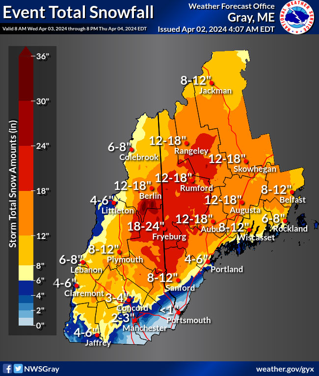
January 23rd Storm Threat: keeping positive vibes, ending chances of futility
in New England
Posted
And just like that it shut off. Measured in 5 or 6 different spots, finished up with somewhere between 16-17". Snowpack in the yard is measuring 24-26" deep. Someone in New Gloucester probably got 18"+.