

etudiant
-
Posts
790 -
Joined
-
Last visited
Content Type
Profiles
Blogs
Forums
American Weather
Media Demo
Store
Gallery
Posts posted by etudiant
-
-
1 hour ago, WidreMann said:
So I guess we're in agreement that climate change is happening and that the sea ice is reflecting a period of ever increasing warming. Right?
Think that you'd get 97% agreement on that score.
Afaik, there is very broad agreement that global temperatures are up about 1 degree K since the 1880s. However, that warming has been in fits and starts, warm in the 1920s, colder in the early 1970s.
Obviously, the issue is to untangle the natural from the human impact, no easy task. Given emissions, major changes in land use and population growth, even the details of the human impact are hard to decipher.
That agreed, I do think that Snowlover91 has a good point, it is disconcerting to have above average ice growth in face of higher than normal air and ocean temperatures. Clearly there is something we do not understand about the process. It may be important or it may be trivial, but it should be investigated.
-
Thank you for this, a lot of work and thought went into it and it is much appreciated.
Any chance of a follow on, maybe towards the end of August?
-
Is this not also near the spot where the Franklin expedition became entombed? These are pretty ideal places for ice to accumulate, no big gyres or currents to flush the multi year ice towards warmer waters.
-
1 hour ago, JWilliam9830 said:
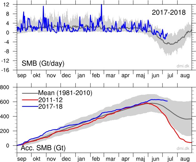
Data from the danish meteorological institute.
http://www.dmi.dk/en/groenland/maalinger/greenland-ice-sheet-surface-mass-budget/
There seems to be a lot more ice than 2011-12. This is during the height of melt season and we are well above the 1981-2010 mean.
Think this data represents the mass balance for the single year only, so we may have an increment to the total ice mass, rather than a wash.
The total Greenland ice cap is estimated at about 2.8 million cubic kilometers, or 2.8 million billion tons of ice, so adding or subtracting a few hundred billion tons does not change the overall picture.
-
 1
1
-
-
2 hours ago, csnavywx said:
EOSDIS Worldview supports this. The pack looks visually much closer to 2009/2013. There's more ponding than those two years, but less than every other year back to '07. With the upcoming TPV pattern setting in again, this year has a good shot of ending up around 5M, despite the low starting volume.
This is all fairly temporary of course. As long as external forcing continues to increase at the current rate (3-4ppm CO2e/yr), it will eventually overwhelm these other factors and cause the pack to collapse regardless. Still on target for the 2030s, imo, even with a stall through the 2020s.
It would have been more productive if this kind of more nuanced appraisal had been articulated, rather than the 'doom is at hand' catastrophic AGW stories that have dominated the discussion.
As is, climate scientists are consequently somewhat in the position of the boy who cried wolf, their alarm falls on deaf ears among the general public.
I
-
36 minutes ago, Vice-Regent said:
We live in a deeply troubled society. Anyone debating that aspect of our life should get the cold shoulder. However I am concerned when such valid points are presented behind a facade of malicious intent or for lack of a better term - trolling. I'm not sure if such methods are effectual in changing the status quo. If nothing else - counter-productive.
Until proven otherwise. Best to stay true to the purpose of this forum. Give us the proof. I have layed our why the Arctic is behaving in this manner - seemingly to shield itself from the onslaught of the heat flux over Siberia and North America. Sadly it just cements our demise even more as people become more complacent and the climate system has a instantaneous state change resulting in multi-meter decadal sea level rise.
Seems that this is a new thought ' the climate system has a instantaneous state change resulting in multi-meter decadal sea level rise.'
There is some evidence in the ice cores that swings can be very abrupt, but afaik, nothing like that is indicated by any of the climate models. So this is postulating a massive model failure, which may well be the case. The counter argument is of course that the current warming has been a cyclical event, somewhat as in the 1920s and that cooling is likely to continue into the 2030s.
-
Thanks, I see where you are coming from, the northern oceans are warmer than in 2012 and the pattern of heat anomalies over Russia is similar.
Against that, the Greenland to Alaska side of the Arctic is below normal, rather than above. That suggests the direction of the flows will matter.
Is there an expectation that the flow direction will be Russia to Canada?
I do remember seeing masses of driftwood deposited on the northern shores of Iceland, which the guide told us had come across the Arctic from Russia, so that may be the rule.
-
The heat is not yet showing up, at least in the DMI (Danish Meteorological Institute) Arctic temperature tracking:
http://ocean.dmi.dk/arctic/meant80n.uk.php
So where is it?
Separately, with all this accumulated oceanic heat, can we forecast a new low for September Arctic ice? What if anything could gum up the process?
It is important to couple the measurements to real forecasts, else the utility of the measurements becomes arguable.
-
Afaik, the Arctic melt is largely driven from below, by warmer ocean water.
It would be very useful to have some actual water temperature data characterizing the various currents that impact the Arctic Ocean.
Obviously the data is really hard to get, but surely someone has worked this problem.
-
1 hour ago, WidreMann said:
Arctic ocean temps remain fairly well above normal, though not quite as bad as last year. I suspect we'll see a slowdown in the refreeze. Not calling for catastrophe, but certainly unlikely to be a big rebound.
vs
Do these air temperature changes have any substantial effect on the ice melting process?
My impression was that melting is mostly driven by direct solar heating and increased sea water temperature.
-
I'd thought the air temperature was not as significant as the water temperature in driving the amount of melting in the Arctic. Is this a misperception?
-
I don't understand why there is this belief in linear models.
Everything we know about climate and weather says jumps are the norm, not slow and gradual transitions from one state to another.
So why would we expect arctic ice to behave differently? Based on precedent, we should bump around a record low for a while .
Then, if the environment remains favorable, we jump to a zero late summer ice regime. The Viking records suggest as much.
The real question is whether this is a cyclical or a secular development. Does anyone have any substantive input towards answering this question?
Arctic Sea Ice Extent, Area, and Volume
in Climate Change
Posted
Thank you, bluewave, for this very useful presentation of the ice data. This kind of presentation helps clarify where things stand much better.