

etudiant
-
Posts
718 -
Joined
-
Last visited
Content Type
Profiles
Blogs
Forums
American Weather
Media Demo
Store
Gallery
Posts posted by etudiant
-
-
1 hour ago, Will - Rutgers said:
lee is my most disappointing child yet
Patience....
-
2 minutes ago, StantonParkHoya said:
They all bend before 70W when you go out in time
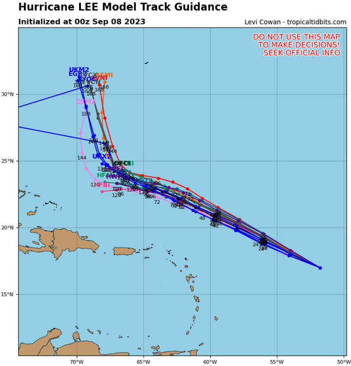
Is there a good explanation for this critical course change or is it projected based on historical precedent?
-
 1
1
-
-
Only some moderate gusts here in Manhattan, not even a sprinkle thus far.
Seems the action was further north, we just swelter some more.
-
NYC had the Lantern Fly food tree planted everywhere. The 'Tree of Heaven' is a good choice for urban trees, resists pollution and abuse better than most native species.
So the Lantern Fly arrived to a well set table, only ray of light is that our birds are getting a taste for them.
-
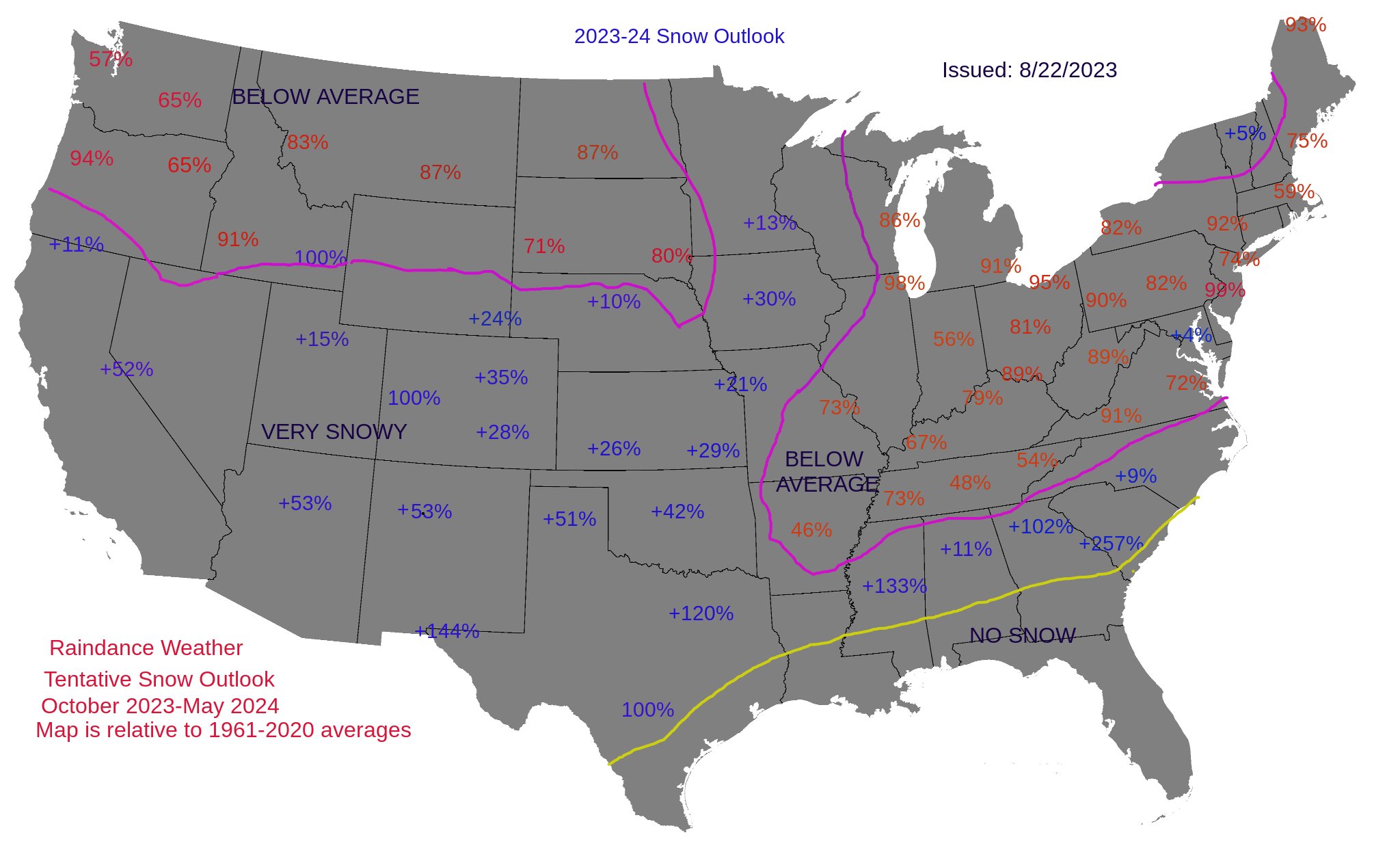
1 hour ago, raindancewx said:
I may update this later. But I'm actually most confident in the snow aspect of the coming cold season. The red numbers are % of the 1961-2020 Oct-May snow average for a spot, and below average. If you see a +Blue% that is the % above the 60-year average you should finish (i.e. +15%, if average is 20 inches = 23").
The blue numbers that say 100% (Grand Junction as an example) without + are forecast to be exactly average. I have the analogs behind this map, but I don't have a weighting I like yet, so not posting them for now.
Thank you for posting this. It puts down a marker with solid detail in the forecast.
I only wish your example was generally emulated.
-
Nothing thus far here in Manhattan's UES, even though the forecast amount gradually rose during the day from.25" to .65", before being slashed to 0.05" now.
Evidently these very localized intense storms remain very difficult to predict.
-
10 hours ago, NorthHillsWx said:
Going to have to be a nuclear September to have anything close to CSU’s prediction come true. This looks like a repeat of last August’s setup in the Atlantic, but worse ENSO for development. Honestly not sure we crack 100 ACE if the only windows for development are right off the east coast or sub tropics. No one’s seen any switch flipping in any modeling and any uptick in long range activity either evaporates or gets punted.
Given that SSTs in the Atlantic are unusually high, is it possible that the hurricane season will be extended, so that October becomes the 2023 September?
-
 2
2
-
-
16 minutes ago, MANDA said:
I know that is why I have been kind of dragging my feet on the project. I'm not capable of going up that high and I can't find anyone to do it for me. I really want to locate the wind equipment in the best spot and that roof peak with a mast would be ideal. Add to that I'm not technical enough to get the system connected and up and running. Looking for help !
Not an installer, but could you rent a cherry picker to mount your gear at a reasonable cost?
Separately, the location looks pretty exposed, great for getting clean measurements, but also potentially a lightning rod.
I'd strongly second uofmiami's recommendation to have it blessed by an electrician, just for peace of mind.
-
14 minutes ago, Allsnow said:
I wonder if we see a urban flood advisory for Manhattan soon
Only if one of the rain bands comes through. Thus far, rainfall rates here have been very subdued, well under the 1"/hr rate.
-
1
-
-
3 minutes ago, dmillz25 said:
Sheesh might get close to 2” at this point with this downpour
Rain here on the Manhattan UES has stopped for the moment. Doubt we got even a tenth of that here.
-
35 minutes ago, Rmine1 said:
And we wait. If we get skunked again tomorrow, I’m going to move to a rainforest
Move to Hilo in Hawaii, all the rain you could ask for and when you're tired of it, just go to the dry and sunny side of the island.
-
16 minutes ago, SI Mailman said:
Closing in on an inch at my personal weather station which is 2 miles east of where I was riding out the storm earlier. Easily my biggest event so far from this stormy stretch
Modest rainfall now under way, UES of Manhattan.
-
11 minutes ago, MJO812 said:
Torrential rain here with thunder
Still dry on the Manhattan UES as of 6.30 PM local time.
-
2 minutes ago, winterwx21 said:
And tomorrow the activity is gonna be widely scattered. We might get something tonight or tomorrow, or we might not get anything at all. We hope but who knows.
So true. The recent NYC Manhattan experience has been that forecast rains tend to disappear as the time approaches. No idea why though.
-
1
-
-
2 minutes ago, nycwinter said:
hearing thunder here in manhattan..
Hearing it as well, but still hazy sunshine and no rain thus far on the UES in Manhattan.
-
4 hours ago, Volcanic Winter said:
For some it’s perhaps a peaceful existence. I’m tired of the enormous crush of people in the NYC / NJ area, personally. I’ve commuted the parkway for 13 years now into the immediate metro and it’s just scarring already, especially this time of year.
I desire tranquility and a bit more nature than what I get where I live within the flat, boring fall line.
Speaking purely in fanciful, idealistic terms; were money no object and lacking any pragmatic considerations I’d want to live in Alaska (puts me closer to my greatest earthly passions, three guesses on what that is
 ) or possibly coastal Maine. Perhaps one day I’ll be able to go exactly where I want, isn’t that the beauty of life?
Afaik, the NYC area expressways and parkways were designed to ensure that the commuters would be ready to kill by the time they got to their office. That helped ensure NYC's dominance in business negotiations.
Alaska is just wonderful, your fancies are entirely justified.
-
 1
1
-
-
1 hour ago, snowman19 said:
We can keep using the persistence argument/forecast but eventually that doesn’t work anymore. Patterns are bound to change, they can’t stay the same forever, especially after almost 10 yearsIs that not like betting on black after red has come up for the last ten throws, because 'it's bound to change'?
-
 1
1
-
-
19 minutes ago, donsutherland1 said:
June started with above normal temperatures. The temperature rose into the 80s across much of the region. Some of the coastal areas saw temperatures hold in the upper 70s.
Again, near record and record heat prevailed north of the region across parts of northern New England and southern Canada. Records included:
Augusta, ME: 93° (old record: 92°, 2013)
Baie-Comeau, QC: 83° (old record: 77°, 2007)
Binghamton: 87° (old record: 86°, 1954 and 2011)
Burlington: 96° (old record: 90°, 2011 and 2013) ***highest so early in the season***
Caribou: 93° (old record: 87°, 1995)
Edmundston, NB: 93° (old record: 83°, 2011)
Fredericton, NB: 95° (old record: 91°, 1937)
Houlton, ME: 93° (old record: 86°, 1937 and 2013)
L'Acadie, QC: 94° (old record: 88°, 2011)
L'Assomption, QC: 95° (old record: 87°, 2011)
Lebanon, NH: 96° (old record: 93°, 2013
Massena, NY: 91° (old record: 87°, 2018)
Millinocket, ME: 96° (old record: 92°, 1920 and 1937)
Miramichi, NB: 95° (old record: 91°, 2018)
Montpelier: 90° (old record: 88°, 2013)
Montreal: 93° (old record: 89°, 1892)
Ottawa: 93° (old record: 92°, 1920)
Plattsburgh: 90° (tied record set in 2013)
Quebec City: 93° (old record: 86°, 2011)
Saranac Lake, NY: 90° (old record: 87°, 1920)
Scranton: 93° (tied record set in 1937)
Sherbrooke: 90° (old record: 87°, 2013)
Syracuse: 91° (tied record set in 1954)Tomorrow will be even warmer with parts of the region approaching or reaching 90°. However, a trough will develop afterward leading to a return of cooler conditions. Some of the models show a fairly impressive cold shot for early June. As a result, Saturday could see temperatures remain in the 60s in New York City and 50s in Boston.
The latest ECMWF weeklies suggest that sustained warmer than normal conditions could develop during or after the second week of June.
The ENSO Region 1+2 anomaly was +2.0°C and the Region 3.4 anomaly was +0.4°C for the week centered around May 24. For the past six weeks, the ENSO Region 1+2 anomaly has averaged +2.28°C and the ENSO Region 3.4 anomaly has averaged +0.42°C. El Niño conditions will very likely develop during the summer.
The SOI was -25.94 today.
The preliminary Arctic Oscillation (AO) was +0.153 today.
On May 30 the MJO was in Phase 8 at an amplitude of 1.112 (RMM). The May 29-adjusted amplitude was 1.353 (RMM).
Meanwhile, the rain we had hoped for here in NYC for this weekend has evaporated. Guess the models did not close.
Very disappointing, we are headed towards drought conditions, with no relief in prospect based on the models.
-
1
-
-
41 minutes ago, bdgwx said:
Maybe I misinterpreted but I read that as it will only be a near normal season despite the warm Atlantic due to the robust El Nino expectation mitigating activity. In other words, had the expectation been for a weak El Nino or neutral ENSO phase then the CSU forecast might have been for an above average season. Or had the Atlantic been cooler with a robust El Nino then the CSU forecast might have been for a below average season. I read that as an acknowledgement of what is happening in both oceans. Did you read it differently?
The issue to me is that it explicitly says local forecasts at the basin wide level are inadequate, that a global perspective is needed.
That makes the problem very much more difficult. Does anyone have a respectable global model?
-
4 hours ago, TheClimateChanger said:
You have to wonder what effect all of this smoke is having from these supercharged, anthropogenic wildfires? Smoke has a massive cooling effect, absorbing, and to some extent, reflecting incoming solar radiation, while mostly transparent to outgoing longwave radiation. There are also a number of studies showing a significant indirect cooling impact through cloud brightening. The smoke particles and aerosols act as cloud condensation nuclei. Since they are more abundant, you wind up with clouds that contain more droplets and are, therefore, brighter or more reflective; however, the droplets are smaller and less apt to produce rainfall. There is also a direct drying effect by limiting convection through cooling of the near surface layer, while warming the air aloft. Both of these would impact surface convection, and through warming aloft, there's probably an impact even on elevated convection.
Maybe it's just me, but it seems like the smoke has really ramped up globally since about the mid 2010s. We have even seen a number of significant pyroCb events which can loft the smoke and aerosols into the lower stratosphere where they can have a much longer residence time similar to volcanic emissions. You don't see this latter effect with ordinary industrial pollution.
Is the wildfire impact enough to off set the reductions in smoke from the various anti pollution initiatives?
It would help to get some real world data as to the reductions, measured at various particulate sizes, in atmospheric pollution.
Without some baselines, it is difficult to generate a robust thesis.
-
9 hours ago, MANDA said:
The below normal months are barely below and the above normal months are well above.
Also, the May normals used are from the more recent 30 years, so elevated from the earlier averages.
May seemed warm and dry here in NYC, certainly more pleasant weather than in most recent Mays.
-
1 hour ago, snowman19 said:
Have to say that this is disappointing.
It recognizes the warmth in the Atlantic and then says it does not count because the Pacific is having an unusual El nino.
Basically says only global models have value, basin wide analysis is inadequate.
Guess I'm not cut out to be a meteorologist, I've no grasp of global models..
-
2 hours ago, jm1220 said:
Back door front wildfire smoke. That… doesn’t happen every day.
What on earth is burning in Nova Scotia?
I have this 'Anne of Green Gables' image of a mostly rural farming oriented province, does not seem a promising site for massive wildfires.
-
This is quite wonderful, a discussion of the various factors that indicate an El Nino developing, done in real time, by experts who are trying to forecast the future based on all available public sources.
It's especially relevant because there is as yet no consensus as to the details, which is what most of us pay attention to.
The possible impact on the Atlantic hurricane season is a separate topic, which however will surely gather increasing attention.
-
2
-
Storm Daniel and medicanes
in Tropical Headquarters
Posted
Only comment that I've seen is that there had been no maintenance of these dams since Qaddafi was overthrown in 2011, due to the ongoing civil war. Nothing about their construction or function though.
Iirc, Qaddafi's signature project was the 'great man made river', to divert water from the Atlas mountains to the population centers, around Tripoli and elsewhere, so he must have been actively building reservoirs. I've no idea whether these dams were part of that effort.