
GunBlade
-
Posts
450 -
Joined
-
Last visited
Content Type
Profiles
Blogs
Forums
American Weather
Media Demo
Store
Gallery
Posts posted by GunBlade
-
-
NW trend has not been our friend this year so guess I’ll bank on the SE trend and go all in on the storm the GFS is showing at the end of its run

-
 1
1
-
-
Being in the SE, seems like there’s rarely better snow than what a good ULL rolling through generates. As long as it’s passing south of you.
Their dynamics result in amazing rates with nice big flakes that add up fast.
-
 2
2
-
-
6 hours ago, SouthCentralWake said:
Yeah @PantherJustinyou were right. This was a bust for us around the CLT area. Go ahead and give me the stuff I deserve. I’m just a optimistic so I was a weenie. Let’s keep it civil though since I’m a State fan
 let’s beat UNC tomorrow.
I’m only a couple miles from CLT and woke up to snow covered ground. Can’t call a bust before the modeled snow even arrives.
")
-
4
-
-
10 minutes ago, wake4est said:
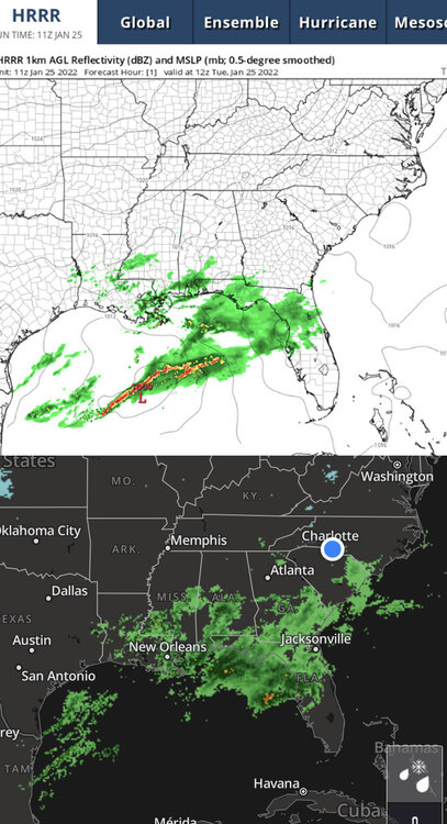
The current HRRR and RAP are showing next to no moisture with those bands.
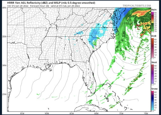
The point isn’t the totals or what the models say right now. It’s the fact that so many people were hoping for that band to give them a chance and then complained about rain and temps 4 hours before it’s supposed to form.
Also, the models don’t show most of the precip falling right now so who knows what to believe anymore.
-
2
-
-
Funny how a little rain makes everyone forget what the models actually showed.
The meso band some of us have been hoping to give us an inch or two hasn’t even formed yet and wasn’t supposed to until around midnight or later.
-
1
-
 3
3
-
-
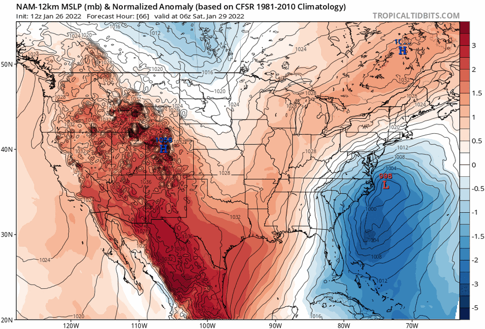
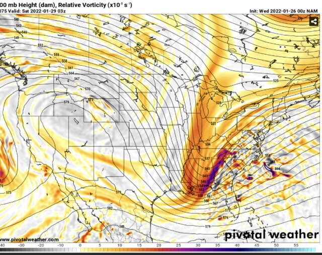
Way too much southern energy being strung out and left behind. That’s why the phase is occurring so late and weak.
-
Canadian had a little better phase as well. Little stronger and further west.
The ridge out west has been strengthening too the past few model runs.
-
1
-
-
2 hours ago, eyewall said:
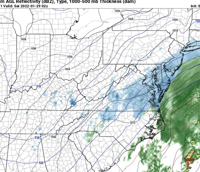
March 2010 Mesoband:
Is that the Chrysler Jeep Dodge and Ram dealership across the street?
If so, our good friends live less than a mile down the road off of Amos Bridges Rd and Waters Edge Dr.
-
8 minutes ago, snowmaker13 said:
Even the frame you mentioned is significantly weaker and the blocking high stronger.
The point being is that the low that forms is not way east OTS. Yes the low is weaker because the phase is weaker and is why the NE misses out.
-
5 minutes ago, snowmaker13 said:
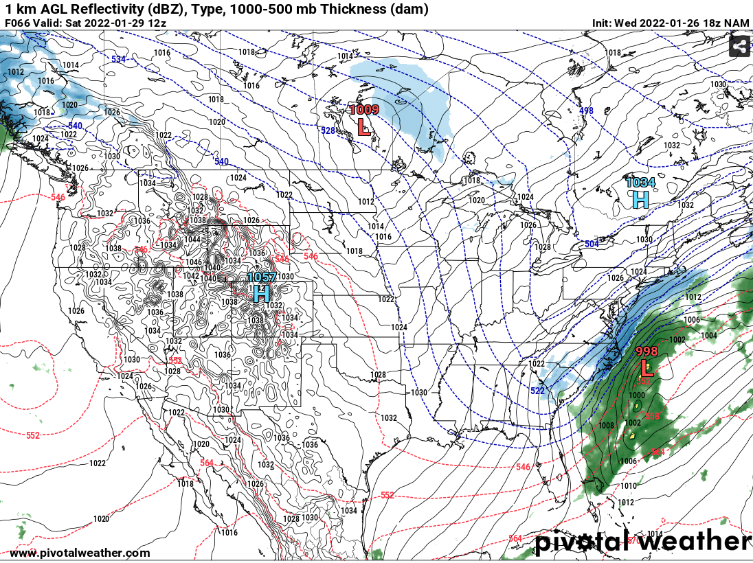
NAM is interesting
That isn't the LP that forms from the phase in the 18z run. This run was a little slower and weaker so you have to go out a couple more frames for the LP that forms.

-
Ouch....


-
1
-
-
Canadian looking alot like GFS so far. See how it plays out.
-
2 minutes ago, burgertime said:
Problem for folks around the CLT and CNC area I see is that this relies a lot on producing enough moisture as it pulls away. Always a tricky situation which is why you really need a good phase and for that low to bomb out. Usually these just leave most high and dry.
Exactly. We (CLT) would really need this to be neutral or negative at hour 60 when that low is off the coast of SC to get us in the NW precip shield and allow it to bomb out by the time it is to the NC coast. That causes issues for eastern NC early in the event, but they still do well as the low is passing them.
-
The GFS looks good overall and the low forms in a good location. It’s just that southern energy is so strung out from being held back that there’s not enough juice in the atmosphere to get the precip really going until it’s too late for most.
-
1
-
-
Yea that southern energy just sits back west much longer
-
1 minute ago, NorthHillsWx said:
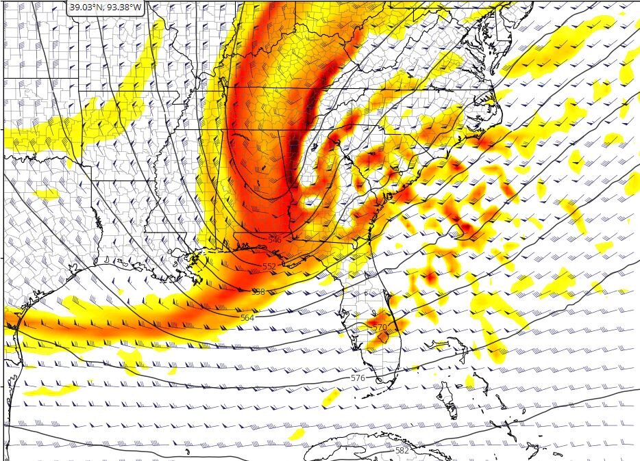
For what it’s worth, the 3k NAM is a very good look on its last frame. That’s going to end well for a lot of folks if you extrapolate that forward
Yup, great low location off the coast of Florida. If that phases early enough and rides up the coast there will be alot of happy people.
-
1 minute ago, TARHEELPROGRAMMER88 said:
RGEM? 12z breakdown anyone?
Little weaker and later phase than 6z run. Much later than NAM so the low is too far north and east by the time it forms. NE NC outerbanks get good snow but not much else.
-
1
-
-
4 minutes ago, Sandstorm94 said:
I don't buy that low being that far east to start and come flying in like a bat out of hell from the south east... If that was closer to the coast then we would have a BIG storm
Sent from my SM-S115DL using Tapatalk
I could be wrong. Looks deceiving but that secondary low that forms ahead of our main low is way off the coast. Once our energy phases and forms a new low, that secondary low dissipates. So it looks like the low comes flying up from the SE but that’s really the secondary low dissipating and our main low forming.
-
1
-
-
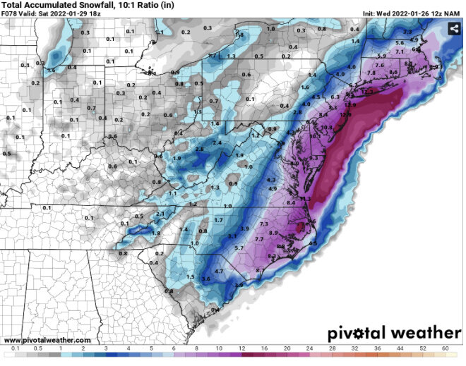
Jackpot for coastal areas and eastern NC though.
-
1
-
-
3 minutes ago, Sandstorm94 said:
Better phase out to 60
Sent from my SM-S115DL using Tapatalk
Yea leaves less energy behind than the last run, much closer to 00z run. Phase looks at little stronger but little too late to jackpot central NC.
-
Yea NAM is about to really wind this one up.
-
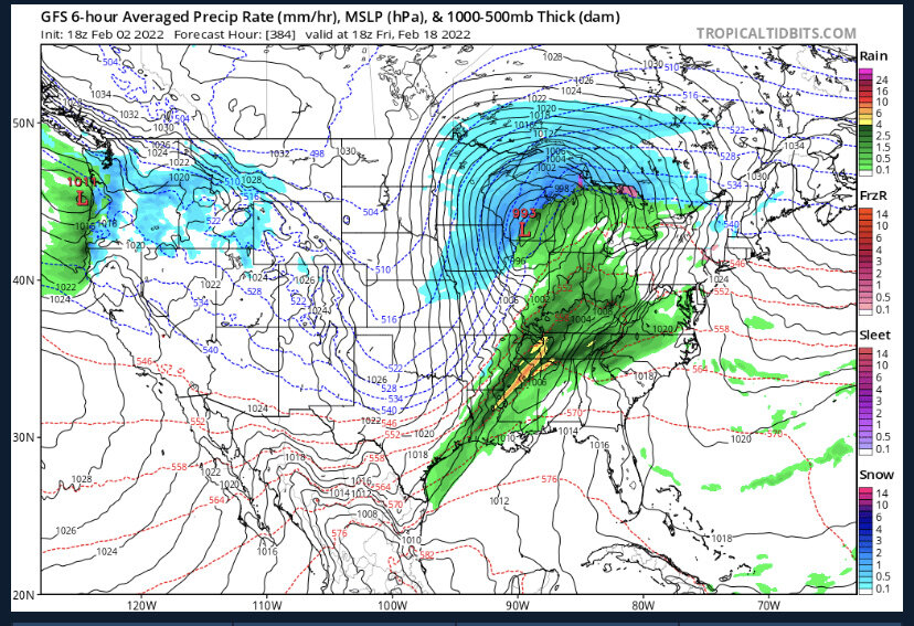
The back and forth uncertainty will likely not stop anytime soon. Short range models don’t even have the current low in the gulf modeled very well. Quite a bit more moisture than shown. Going to be a long ride this week.
-
18 minutes ago, Beach Snow said:
Canadian delayed today?
Yup "GDPS and RDPS maps may be delayed or missing due to data flow problems at Environment Canada"
-
The 06z NAM looked like it was on track for a better phase sooner. RGEM looked pretty good as well. The 12z NAM looks like it’s on its way to improve upon the 06z.
-
1
-


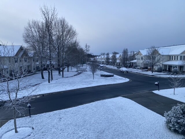
February 2022 Obs.
in Southeastern States
Posted
Miserable cold rain here.