

HKY1894
-
Posts
190 -
Joined
-
Last visited
Content Type
Profiles
Blogs
Forums
American Weather
Media Demo
Store
Gallery
Posts posted by HKY1894
-
-
Nudged south maybe it looks like??
Slightly looks like CLT has 3 inch qpf probably 2.4+ everywhere else
.-
 1
1
-
-
00z FV3 big again
-
Canadian is massive hit, especially for mountains and western piedmont
-
4 minutes ago, griteater said:
18z Euro compared to 12z was similar overall with temperatures. It brings the 850 0 deg back to just east of the NC Mtns during, say, the 2nd half of the heavy precip portion of the storm. It was wetter this run thru NC where there is a large area of at least 2 inches liquid. Here are the last 4 runs of total precip for the storm to Monday morning (12z Mon)

QPF seems to be on an upward trend since last nights 0z run on many models specfically on FV3 and euro
-
mother of god
.thumb.png.576ade5ac7e9c13613aa35371ceb167e.png)
-
 5
5
-
-
The skew-t's for the Asheville area don't really show a major warm nose on the NAM. Literally looks like it takes part of the column above 850 just *barely* above freezing. Still easily overcome by even decent rates IMO.
Agreed, feel like GSP got nervous from low QPF runs of 12z gfs/nam
.-
1
-
-
Yeah way to early to call bust especially northern mountains globals all look absolutely great right now only bad model is nam and it’s not even bad in mountains still drop 14 or more in Boone. More worrisome for Asheville area but if globals are closer to reality even you guys are gonna get hit hard. The NAM past 48 hours has been a total joke in the Midwest with this even so it’s laughable to even consider it right now
. -
1 minute ago, MotoWeatherman said:
Can you please provide link for this? I'm coming up blanks looking for it.
Thanks!
http://mageval.ncep.noaa.gov/ It's just under gfs like normal its the eval page though so it's FV3
-
From the ncep maps for FV3 looks like the northern stream closed low drops decent snow on monday. QPF over 2 inches across most of state storm total
-
1
-
-
18z FV3 is another QPF bomb
-
1
-
-
QPF looks better on 18z gfs, One positive trend on both NAM and old GFS at 18z
-
NAM has been garbage in the Midwest at 60 hour leads for now I think it should be discounted. I believe the warm nose will affect clt but the way it drives it all the way to the escapement basically I’m not buying right now.
. -
I favor the Control run over the EPS. As it shows No snow for Ji and NW DC Metro.
He said we are taking there snow last night
. -
Mean

Control run
.-
3
-
-
Mean

Control run
.-
1
-
-
EPS and Euro is locked in boys and girls very similar eps QPF and snowfall mean compared to 00z actually 12z increased slightly
.-
3
-
-
 Kuchera through 96
.-
5
-
-
Euro appears to be a crush job for western NC more closely matches FV3 UK and CMC for sure
.-
3
-
1
-
-
-
The s/w is sharper and more negatively tilted than the FV3 at 72 hours. Just based off of 500mb look QPF shouldn’t be low here.
.-
1
-
-
To be fair in terms of QPF the fv3 more closely matches the ukmet and cmc on the 12z data
The eps at 0z had 2 inches of QPF all the way into northern foothills. So at this time the consensus is for more QPF than gfs/nam that could change but as of now no trend
.-
2
-
-
-
Submitted without comment.
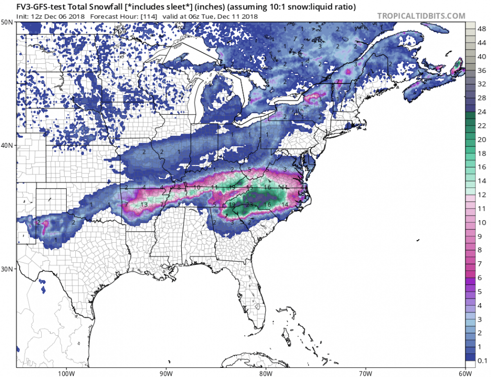
The FV3 is night and day with QPF vs op gfs. Feel like this will be a good test. This year has trended more QPF in our bigger rain events during the fall so it fits the pattern
.-
2
-
-
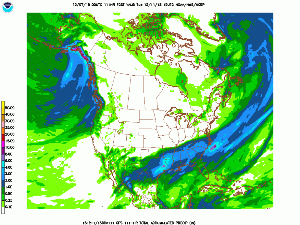
12z FV3 has much more QPF the current gfs. Storm totals nearing 2 inches all the way to VA border more in line with other globals
.

.png.ad6265351621ad3c0470fa594bf41465.png)

December 8-10, 2018 Winter Storm
in Southeastern States
Posted
If FV3 euro CMC and UK all blow the QPF forecast this badly I’ll be surprised this thing is juiced
.