

HKY1894
-
Posts
190 -
Joined
-
Last visited
Content Type
Profiles
Blogs
Forums
American Weather
Media Demo
Store
Gallery
Posts posted by HKY1894
-
-
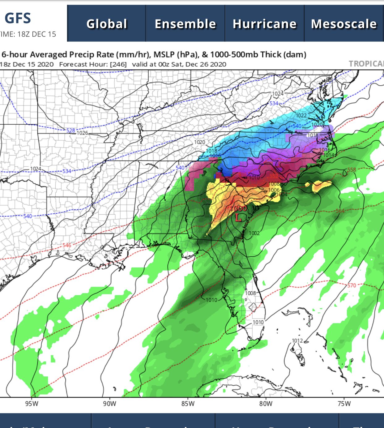
Christmas night snowstorm on happy hour gfs ...........we take

-
 7
7
-
 2
2
-
-
NAM is lights out along escarpment in NW NC
-
2
-
-
Opinions of chasing this to Winchester? I assume maybe Hancock or Hagerstown may be slightly better? Still don’t trust the mesoscale models yet for banding.
-
Looking good headed into first couple weeks of January. Think we will have chances to score big. Much improved from last winter
-
Just now, AllWeather said:
Yupp. And does naughty things.
I want to chase this but it’s gonna be stressful trying to plan ahead to setup near best banding. Will have to make a decision by Tuesday.
-
Northern mountains looking good for midweek system. Gut feeling but this has consistently trended better today.
-
2
-
-
Just now, wncsnow said:
Going to be an interesting week for sure, especially for northern mountain folks.
.........December 09 miller b style?
-
12z euro is interesting. Gfs is much different, if something like euro occurs I could see this trending better for climo favored areas in western part of NC. Blocking and hp to the north is classic cad setup
-
3 hours ago, MotoWeatherman said:
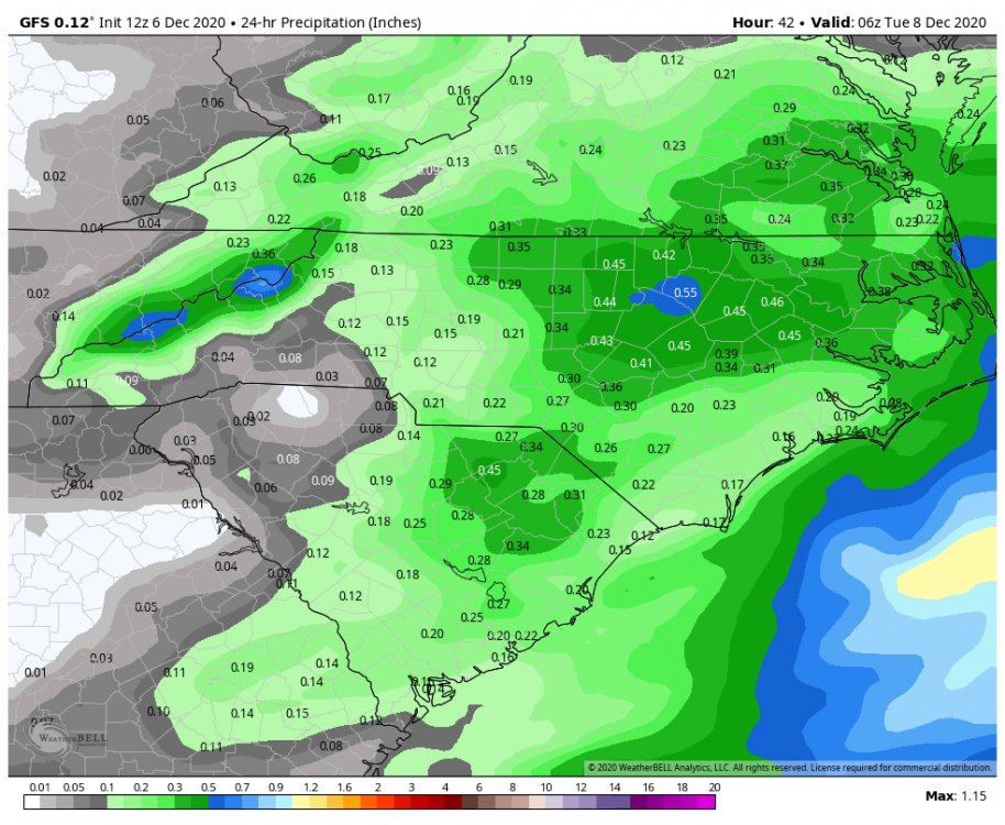
12z GFS is mint for the mountains. This is the 24hr QPF ending 1am Tuesday. I would expect precip to be all snow above 4k feet in the northern mountains starting sometime near midnight tonight. Based on this QPF map, I would expect a likely 3-5 inches for areas above 4k feet especially the northern mountains.
Thinking about chasing this up at beech, what times does it look to start? Trying to figure out when to get up there
-
Snowing lightly in boone starting to accumulate slowy
18z gfs is very interesting for this weekend, shows changeover to heavy snow as upper low moves over
-
1
-
-
12z gfs running, out to 108 the energy out west has a different look than last run. This is gonna be a big run for somebody just hope it’s the southeast
-
3 minutes ago, Buddy1987 said:
Am I imagining things or does Euro have a tendency to not be on steroids during a certain time frame. I know the tendency to not eject s/w out of the southwest u.s. but Idk if I'm just confusing it to where itll dig storms to Cuba and then correct itself.
I feel like it’s so hard to predict model bias sometimes. Every storm is unique and models are so dynamic that all storms are modeled slightly different. But a lot of boxes are checkEd on this threat. Great high latitude blocking, 50-50 low to hold HP in position. One issue with euro is moving 50/50 out of the way too quickly.
Just need to see euro turn more neutral tilt with the s/w. -
The setup looks nice but expect more trends, worrisome to see euro suppressed but 12z made a step in right direction. The trends have been good today that’s all that can be said at this point.
-
2
-
-
This map is classic look for an east coast winter storm. Ridge axis out west could move to the west a little maybe.
-
1
-
-
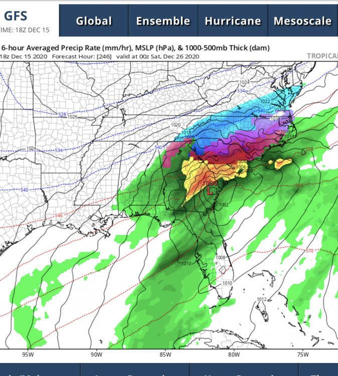
0z gfs shows big storm and it's colder than 18z for Dec 21st-22nd. 500mb pattern is pretty classic for a big dog.
-
18z gfs has a really nice setup for 12/21, verbatim it's 35 and rain for the north of 40 crowd but that has the look of a classic miller A snowstorm as modeled which is probably incorrect.
-
3 hours ago, Hvward said:
I am interested in the possibility for a wintry mix around WNC on Wednesday Night/Thursday morning. It all depends on timing with the first wave that moves in from the southern stream. 6z GFS is much more progressive with the wave, allowing the moisture to move in quickly while a +1040mb high retreats to the NE. Euro's temp profile is very similar to the GFS but it is much slower with the initial wave. A weak low like the GFS shows would have a small warm nose and with it running into such a strong high, the CAD could be substantial. The next two days of model runs it will be crucial to focus on timing. The ridging in the Atlantic is something you really like to see though and all long range models are showing it. Should be a fun month of tracking systems.
Originally the euro showed winter storm, the timing of the high pressure was better for weekend wave. Now we have to hope GFS has right idea of keying on the weak s/w before next weekends rainstorm. all a matter of timing precip with optimal CAD config.
-
GEFS offers some support for op. CMC has no wave other than the weekend rain storm. Will have to watch trends for a few more model cycles.


-
Well I’m at 190% of seasonal average and we’re not even halfway through winter. Euro seasonal and weeklies look epic for rest of winter after this relaxation. Feeling like this might be headed for a top 5 winter for western part of the state. Precipitation hasn’t been an issue all year. Just need another nice Miller A
.-
 1
1
-
-
I’m reducing snowfall totals for Buncombe and Henderson counties based on an analysis of all new data. Boone is all snow, just lower QPF. There will be a layer of warm air aloft that makes it to us overnight. So, while surface temperatures will be in the mid 20s, it will be above freezing at 10,000 feet. So...
Asheville: 4-8" of snow and 1-2" of sleet, may end as freezing rain
Hend/Zirconia: 3-7" of snow and 2-4" of sleet, some minor glazing possible
Now, if the warm nose fails to materialize (possible, but seems like it will), then the forecast is:
AVL: 10-15"
HEND: 15-20"
So you see what a huge deal this layer of warm air is aloft. I will post an update / revision later if conditions change.
Sorry for imby question, but in your opinion how do you feel about Lenoir/Wilkesboro area?
. -
All gonna come down to warm nose. Wouldn’t trust the globals fully. But the euro and FV3 consistency has been impressive
.-
3
-
-
Everything still on track, if it plays out like fv3 euro and ukmet outputs it will be one of the greats we all talk about years from now
.-
1
-
-
-
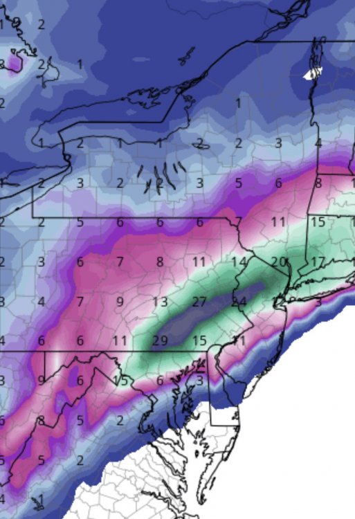
FV3 snow map is unbelievable especially the consistency over this week
.


Mid to Long Term Discussion 2020
in Southeastern States
Posted
Interested in week leading into New Years. The -NAO means business