ORFDawg2013
-
Posts
472 -
Joined
-
Last visited
Content Type
Profiles
Blogs
Forums
American Weather
Media Demo
Store
Gallery
Everything posted by ORFDawg2013
-

Richmond Metro/Hampton Roads Area Discussion
ORFDawg2013 replied to RIC Airport's topic in Mid Atlantic
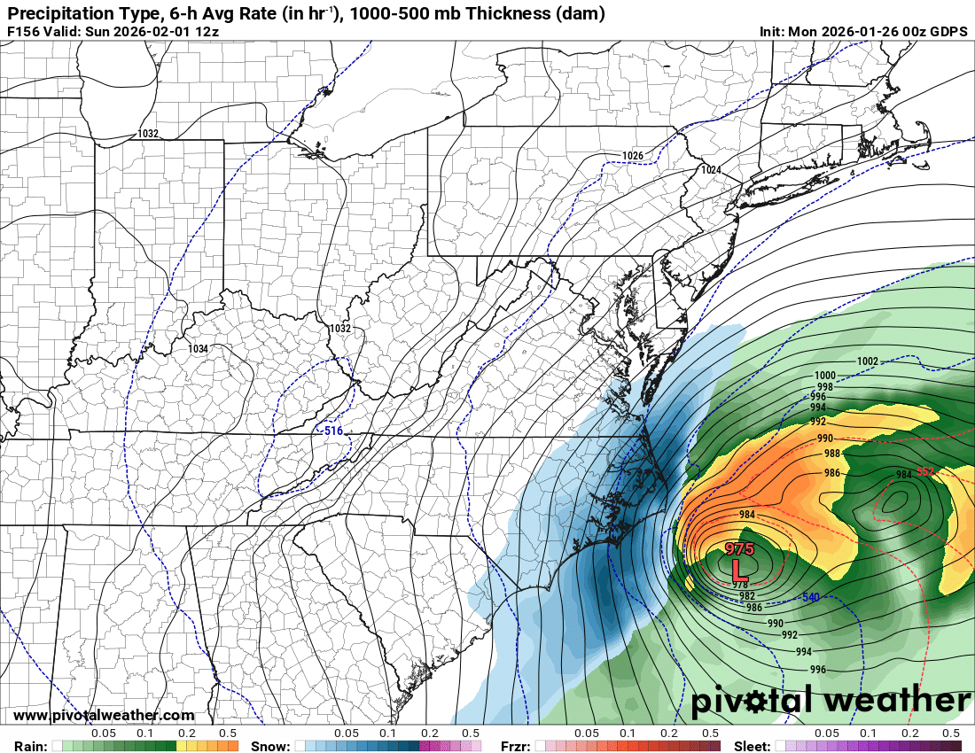
00z CMC is a deeper coastal low closer to the coast!
-
Richmond Metro/Hampton Roads Area Discussion
ORFDawg2013 replied to RIC Airport's topic in Mid Atlantic
-
Richmond Metro/Hampton Roads Area Discussion
ORFDawg2013 replied to RIC Airport's topic in Mid Atlantic
00z GFS is an Eastern NC/SE VA scrape for next weekend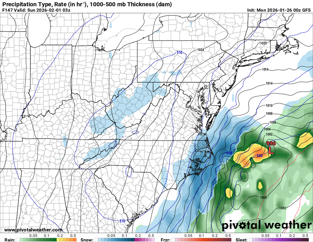
-
Richmond Metro/Hampton Roads Area Discussion
ORFDawg2013 replied to RIC Airport's topic in Mid Atlantic
Deck already ice here in Norfolk from that batch that just moved through! -
Richmond Metro/Hampton Roads Area Discussion
ORFDawg2013 replied to RIC Airport's topic in Mid Atlantic
18z Euro has our weekend storm again! -
Richmond Metro/Hampton Roads Area Discussion
ORFDawg2013 replied to RIC Airport's topic in Mid Atlantic
Yep, just poked my head out here in Norfolk near Ghent and it's a pingfest. Time to take one last look at the snow on the ground. It'll be washed away when I wake up in the morning -
Richmond Metro/Hampton Roads Area Discussion
ORFDawg2013 replied to RIC Airport's topic in Mid Atlantic
These rates remind me of the big storm we had last winter that dumped 12''+ Too bad that's not the setup this time! -
Richmond Metro/Hampton Roads Area Discussion
ORFDawg2013 replied to RIC Airport's topic in Mid Atlantic
Just went and walked around the Ghent area in Norfolk. Grass not all the way covered but snow sticking on sidewalks and roadways. Maybe a dusting to 1/4'' at the moment. Hopefully we can eek out an inch before the sleet starts to mix in and then the rain comes to wash it all away. -
Richmond Metro/Hampton Roads Area Discussion
ORFDawg2013 replied to RIC Airport's topic in Mid Atlantic
Finally got small flakes in Norfolk! -
Richmond Metro/Hampton Roads Area Discussion
ORFDawg2013 replied to RIC Airport's topic in Mid Atlantic
12z Euro suppressed for next weekend. -
Richmond Metro/Hampton Roads Area Discussion
ORFDawg2013 replied to RIC Airport's topic in Mid Atlantic
Until the last few frames lol -
Richmond Metro/Hampton Roads Area Discussion
ORFDawg2013 replied to RIC Airport's topic in Mid Atlantic
Tracks too close to the coast for us in SE VA/NE NC but still, what a look! Also develops a secondary low that rides right behind it!
-
bonkers is an apt description!
-
Richmond Metro/Hampton Roads Area Discussion
ORFDawg2013 replied to RIC Airport's topic in Mid Atlantic
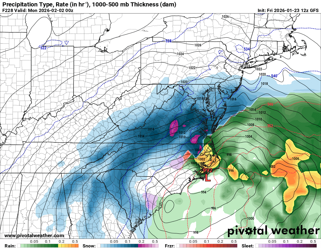
Miller A incoming on 12z GFS! -
Richmond Metro/Hampton Roads Area Discussion
ORFDawg2013 replied to RIC Airport's topic in Mid Atlantic
Threat next weekend is back on the 00z GFS but it cuts way inland. -
Richmond Metro/Hampton Roads Area Discussion
ORFDawg2013 replied to RIC Airport's topic in Mid Atlantic
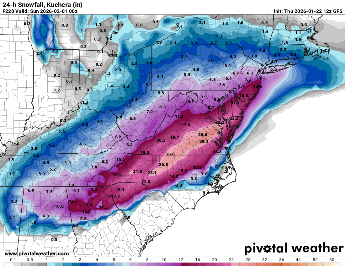
I'll be SHOCKED if we hit 4'' of snow here in Norfolk, but I'll gladly take it before it gets washed away by sleet and rain! -
Richmond Metro/Hampton Roads Area Discussion
ORFDawg2013 replied to RIC Airport's topic in Mid Atlantic
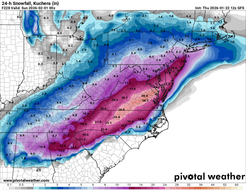
No, I showed 24 hour snowfall for the time period of the next threat. Nothing from this current storm is reflected in that. -
Richmond Metro/Hampton Roads Area Discussion
ORFDawg2013 replied to RIC Airport's topic in Mid Atlantic
That's just the amount for the next threat. -
Richmond Metro/Hampton Roads Area Discussion
ORFDawg2013 replied to RIC Airport's topic in Mid Atlantic
-
Richmond Metro/Hampton Roads Area Discussion
ORFDawg2013 replied to RIC Airport's topic in Mid Atlantic
6z GFS had it WAY suppressed so that's good news at this stage lol . -
Richmond Metro/Hampton Roads Area Discussion
ORFDawg2013 replied to RIC Airport's topic in Mid Atlantic
00z Euro has an absolute Miller A coastal low for the next threat this run! -
Richmond Metro/Hampton Roads Area Discussion
ORFDawg2013 replied to RIC Airport's topic in Mid Atlantic
Major Ice Storm for VA this run of the Euro -
Mixing ZR as far north as DC and S. NJ is crazy!
-
Richmond Metro/Hampton Roads Area Discussion
ORFDawg2013 replied to RIC Airport's topic in Mid Atlantic
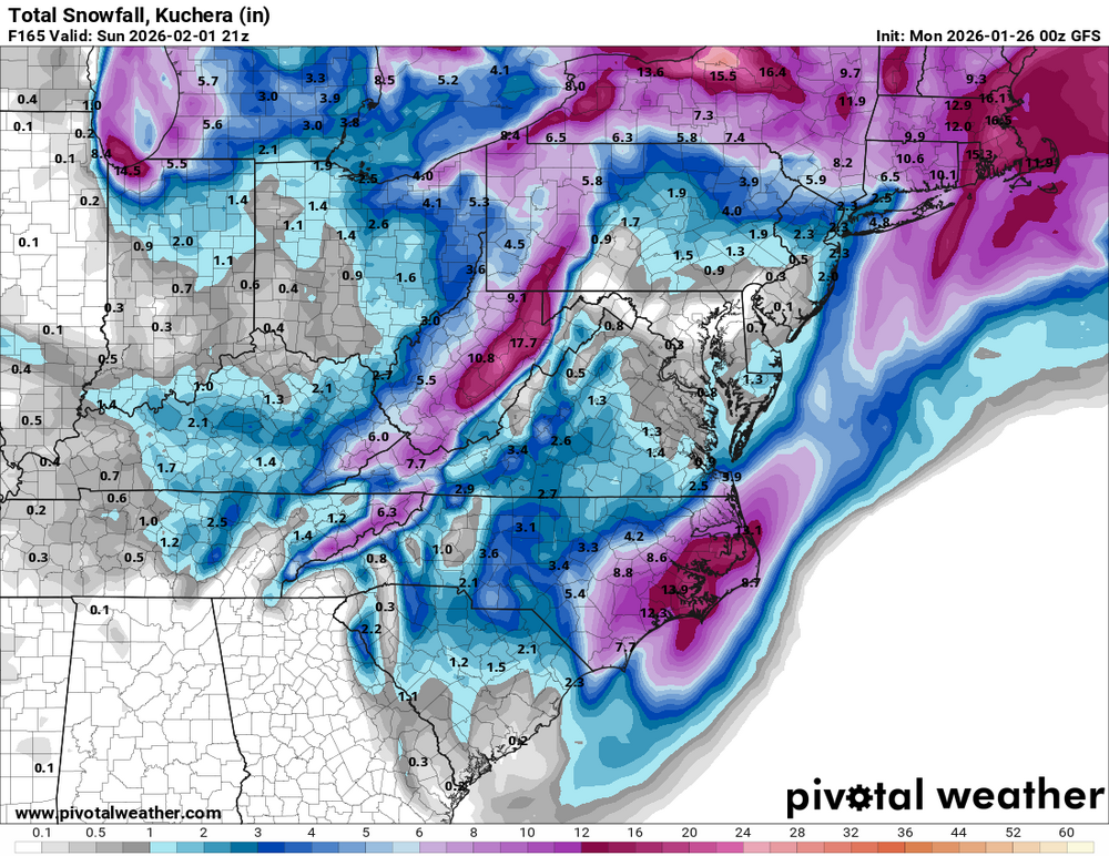
Wow. Euro is barely a front end thump of snow for VA, then ZR for most except for the coast where we're all (thankfully) just rain. ZR even makes its way up to DC! -
Richmond Metro/Hampton Roads Area Discussion
ORFDawg2013 replied to RIC Airport's topic in Mid Atlantic
Kuchera is going to be your best estimate, but even that uses an assumption. So it's not going to be completely accurate.