

chris624wx
-
Posts
291 -
Joined
-
Last visited
Content Type
Profiles
Blogs
Forums
American Weather
Media Demo
Store
Gallery
Everything posted by chris624wx
-

Richmond Metro/Hampton Roads Area Discussion
chris624wx replied to RIC Airport's topic in Mid Atlantic
Another bay streamer moving through VB right now. Such a cool phenomenon! -
Richmond Metro/Hampton Roads Area Discussion
chris624wx replied to RIC Airport's topic in Mid Atlantic
Had around 2.1 inches near Ghent/Downtown Norfolk when I went to measure around 2 AM last night once the last band moved through. That was before the bay steamer developed though. Definitely a nice event especially since we didn't have to worry about mixing issues. If we can get something else this winter, I'd be down! -
Richmond Metro/Hampton Roads Area Discussion
chris624wx replied to RIC Airport's topic in Mid Atlantic
It's really putting it down! -
Richmond Metro/Hampton Roads Area Discussion
chris624wx replied to RIC Airport's topic in Mid Atlantic
Probably the heaviest it's been all night! -
Richmond Metro/Hampton Roads Area Discussion
chris624wx replied to RIC Airport's topic in Mid Atlantic
Visibility with this band really went down! Wring it all out, atmosphere! -
Richmond Metro/Hampton Roads Area Discussion
chris624wx replied to RIC Airport's topic in Mid Atlantic
Going to enjoy it as it moves through. Hard to be upset with it ending earlier than modeled when this was OTS 36 hours ago -
Richmond Metro/Hampton Roads Area Discussion
chris624wx replied to RIC Airport's topic in Mid Atlantic
Yeah, I just came in from walking around. It looked like maybe 1.5'' here near Downtown Norfolk. -
Richmond Metro/Hampton Roads Area Discussion
chris624wx replied to RIC Airport's topic in Mid Atlantic
I hope that happens but it just feels like the window is closing earlier than it was supposed to looking at that NW edge -
Richmond Metro/Hampton Roads Area Discussion
chris624wx replied to RIC Airport's topic in Mid Atlantic
Need that heavy band to work it's way 20 miles north or so lol -
Richmond Metro/Hampton Roads Area Discussion
chris624wx replied to RIC Airport's topic in Mid Atlantic
FLAKES near Ghent/Downtown NFK! -
Richmond Metro/Hampton Roads Area Discussion
chris624wx replied to RIC Airport's topic in Mid Atlantic
Still desperately looking under lamp posts here -
Richmond Metro/Hampton Roads Area Discussion
chris624wx replied to RIC Airport's topic in Mid Atlantic
Especially with the wind! -
Richmond Metro/Hampton Roads Area Discussion
chris624wx replied to RIC Airport's topic in Mid Atlantic
Tim Pandajis' latest post -
Richmond Metro/Hampton Roads Area Discussion
chris624wx replied to RIC Airport's topic in Mid Atlantic
-- Changed Discussion -- As of 320 PM EST Tuesday... Key Messages: - Accumulating snow is expected across Northeast North Carolina and Southeast Virginia tonight. - A Winter Storm Warning has been issued for Norfolk, Portsmouth, Chesapeake, and Virginia Beach. - Winter Storm Warnings have been issued for Northeast North Carolina east of the Chowan River, with Winter Weather Advisories from interior northeast North Carolina to the rest of southeast Virginia. - Additional Cold Weather Advisories are in effect for late tonight into Wednesday morning. Afternoon wx analysis shows a broad, positively tilted trough stretching from the Great Lakes to Southern Plains. At the surface, low pressure continues to deepen in the Gulf of Mexico (with impressive snowfall amounts along the Gulf coast), while Arctic high pressure resides from TX to the Mid MS River Valley. Locally, it is very cold with temps only in the mid 20s under BKN-OVC mid level clouds on the east side of the trough axis. There are actually a few light radar echoes in the Piedmont, but this is obviously not reaching the ground yet as the low-levels are extremely dry. The shortwave trough is progged to sharpen a bit as it approaches and crosses the area late this evening through early Wednesday morning...while low pressure tracks NE well off the southeast/Carolina coast. By this evening (as the shortwave approaches), mid-level WAA will increase area-wide. In addition, model cross sections continue to depict favorable sloping frontogenesis with vertical ascent within the DGZ. This would normally provide enough forcing for ascent to result in widespread light to moderate snow. However, the low-levels will initially be very dry with cold/dry advection continuing overnight. So, the main forecast challenge will is figuring out how far north the snow will be able to reach the ground. While there will likely be a rather sharp cutoff with no snow NW and 1-2" of snow only 30-50 miles to the SE, the 12z models have trended farther north and confidence has increased enough to upgrade Norfolk, Portsmouth, Chesapeake, and VA Beach to the Winter Storm Warning. While there could be a few hours worth of snow resulting in very minor (~0.5") accums near and just to the north of an Emporia-Williamsburg-Ocean City line...the dry air likely wins out here (and especially farther NW). Farther to the SE (especially toward the coast), expect several hours worth of light to moderate snow beginning between 6-9 PM and ending from NW-SE early Wed AM. Given the cold temps, SLRs likely reach 15-20:1 which will likely result in 3-4" of accumulation in most of NE NC and in Norfolk/VA Beach. 4-5" totals are expected in Camden/Currituck Counties. Will have to watch for localized higher totals in Norfolk/Portsmouth/Chesapeake/VA Beach due to moisture enhancement form northerly flow off the Ches. Bay. Winter Wx Advisories are in effect for 1-3" of expected snow from interior NE NC to the Peninsula/VA Eastern Shore. Even in areas just outside the advisory, snow will accumulate efficiently (even on roadways) given cold/dry ground. The synoptic snow should end by 3 AM in SE VA and 5 AM in NE NC. The vast majority of the winter headlines are from 5 PM this aftn through 7 AM Wednesday. However, have run the warnings through 18z/1 PM for Norfolk/Chesapeake/VA Beach given the possibility of some additional (highly localized) minor accums from bay effect snowfall through the morning after the synoptic snow ends. Low temperatures tonight drop into the upper single digits NW, to around 20F SE, with wind chills from around 0F NW to around 10F SE. The Cold Weather Advisory remains in effect from late tonight into Wednesday morning. Updated AFD from AKQ this afternoon -
Richmond Metro/Hampton Roads Area Discussion
chris624wx replied to RIC Airport's topic in Mid Atlantic
Hugging the 3K NAM haha -
Richmond Metro/Hampton Roads Area Discussion
chris624wx replied to RIC Airport's topic in Mid Atlantic
From AKQ's AFD: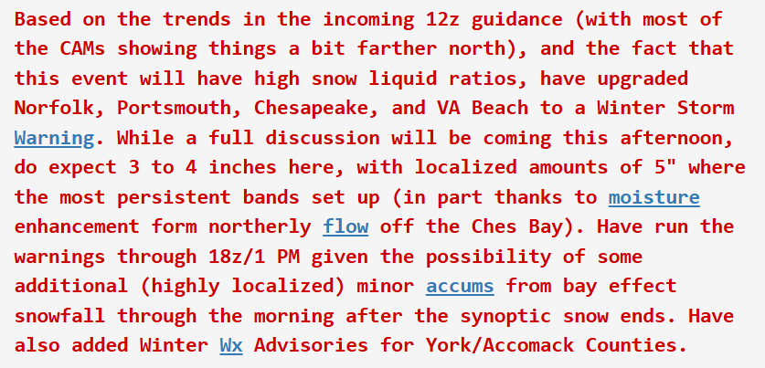
-
Richmond Metro/Hampton Roads Area Discussion
chris624wx replied to RIC Airport's topic in Mid Atlantic
Let's go! -
Richmond Metro/Hampton Roads Area Discussion
chris624wx replied to RIC Airport's topic in Mid Atlantic
Seriously got whiplash from going from bone dry modeling to this in 24 hours. Glad I went and got some groceries yesterday before everyone starts rushing in today! -
Richmond Metro/Hampton Roads Area Discussion
chris624wx replied to RIC Airport's topic in Mid Atlantic
06z HRRR definitely more NW than it was at 00z. An event for the entire Southside and edging up to the Peninsula -
Richmond Metro/Hampton Roads Area Discussion
chris624wx replied to RIC Airport's topic in Mid Atlantic
00z HRRR wasn't all too impressive, unfortunately -
Richmond Metro/Hampton Roads Area Discussion
chris624wx replied to RIC Airport's topic in Mid Atlantic
Thanks RIC! Trends are definitely looking better down here. Hopefully continuing during the 00z runs! -
Richmond Metro/Hampton Roads Area Discussion
chris624wx replied to RIC Airport's topic in Mid Atlantic
Hearing 18z Euro is a nudge NW again but I don't have access to it. -
Richmond Metro/Hampton Roads Area Discussion
chris624wx replied to RIC Airport's topic in Mid Atlantic
Nice! And it was suppressed to hell yesterday! -
Richmond Metro/Hampton Roads Area Discussion
chris624wx replied to RIC Airport's topic in Mid Atlantic
A glimmer of hope haha Let's see if the other short range hi res models come around -
Richmond Metro/Hampton Roads Area Discussion
chris624wx replied to RIC Airport's topic in Mid Atlantic
At this point I'd celebrate the ground turning white with how tiring this has been to track


