ORFDawg2013
-
Posts
472 -
Joined
-
Last visited
Content Type
Profiles
Blogs
Forums
American Weather
Media Demo
Store
Gallery
Everything posted by ORFDawg2013
-

Richmond Metro/Hampton Roads Area Discussion
ORFDawg2013 replied to RIC Airport's topic in Mid Atlantic
Finally get teeny tiny flakes in Norfolk, near downtown -
Richmond Metro/Hampton Roads Area Discussion
ORFDawg2013 replied to RIC Airport's topic in Mid Atlantic
Until it starts to snow, I'm going to doubtful at anything more than a dusting lol -
Richmond Metro/Hampton Roads Area Discussion
ORFDawg2013 replied to RIC Airport's topic in Mid Atlantic
Thanks! Hopefully this one delivers, but if not, hopefully the next one will for all of us! -
Richmond Metro/Hampton Roads Area Discussion
ORFDawg2013 replied to RIC Airport's topic in Mid Atlantic
At this point, check please! i'm at the bargaining phase lol -
Richmond Metro/Hampton Roads Area Discussion
ORFDawg2013 replied to RIC Airport's topic in Mid Atlantic
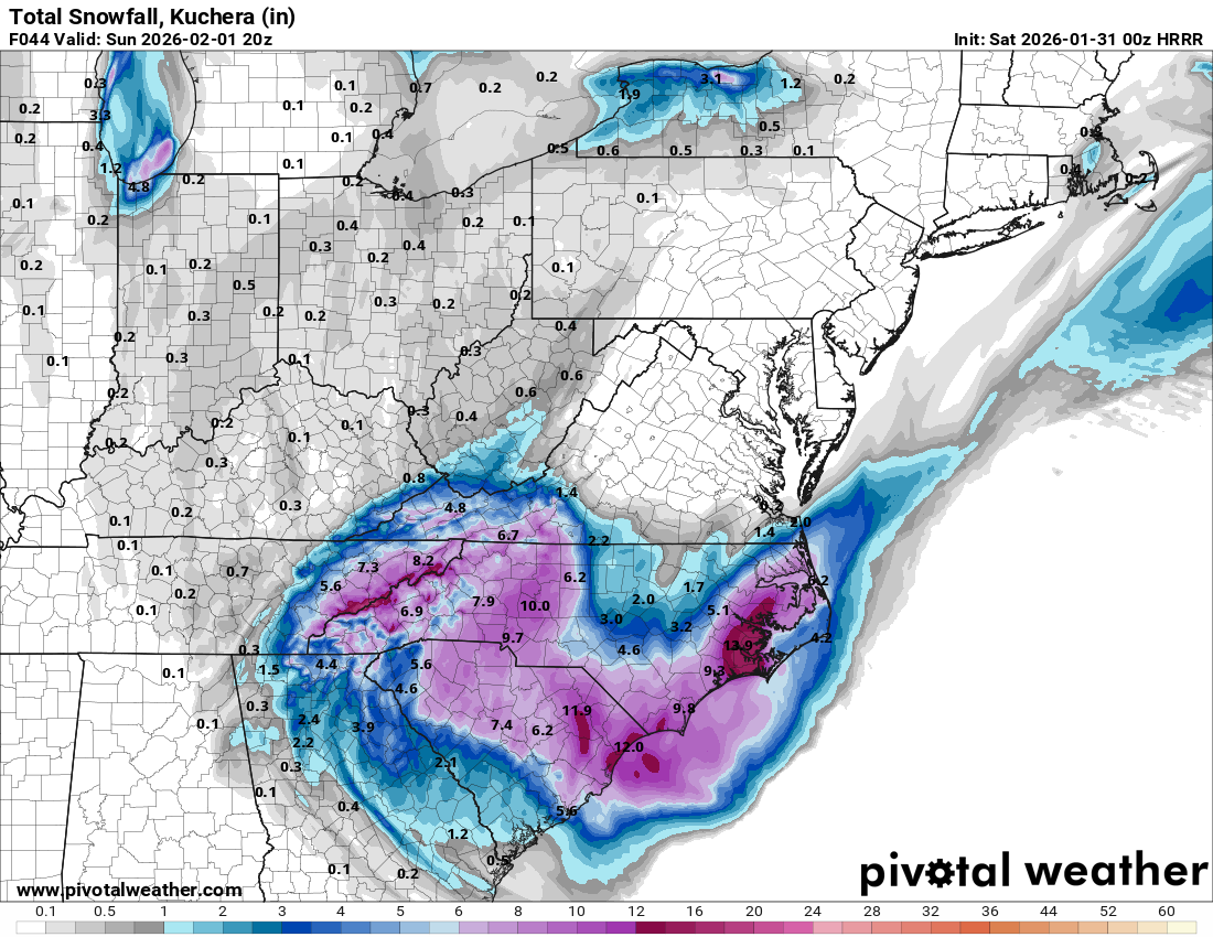
00z HRRR better for Southside HR than it was at 18z. Hopefully that's the start of an adjustment!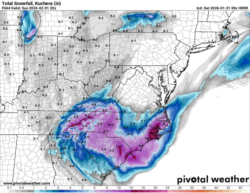
-
The “I bring the mojo” Jan 30-Feb 1 potential winter storm
ORFDawg2013 replied to lilj4425's topic in Southeastern States
Tallahassee -
The “I bring the mojo” Jan 30-Feb 1 potential winter storm
ORFDawg2013 replied to lilj4425's topic in Southeastern States
I've got family in Oconee County. Hoping y'all all get buried down there! -
Richmond Metro/Hampton Roads Area Discussion
ORFDawg2013 replied to RIC Airport's topic in Mid Atlantic
Globals vs CAMs right now... -
Richmond Metro/Hampton Roads Area Discussion
ORFDawg2013 replied to RIC Airport's topic in Mid Atlantic
Wakefield expressing high uncertainty even this close to the event. Can't say they're alone in that! -
The “I bring the mojo” Jan 30-Feb 1 potential winter storm
ORFDawg2013 replied to lilj4425's topic in Southeastern States
Yeah, not liking the trends for SEVA on the 3K and HRRR. Seems crazy that we could get shut out entirely. -
Richmond Metro/Hampton Roads Area Discussion
ORFDawg2013 replied to RIC Airport's topic in Mid Atlantic
looks like a Southern Slider -
The “I bring the mojo” Jan 30-Feb 1 potential winter storm
ORFDawg2013 replied to lilj4425's topic in Southeastern States
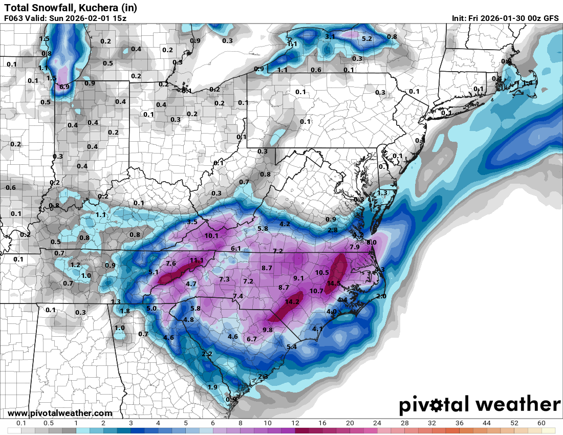
Was hoping it'd be more moist and NW into VA like the GFS/CMC/ICON was. Only .2 in Virginia Beach is not good -
Richmond Metro/Hampton Roads Area Discussion
ORFDawg2013 replied to RIC Airport's topic in Mid Atlantic
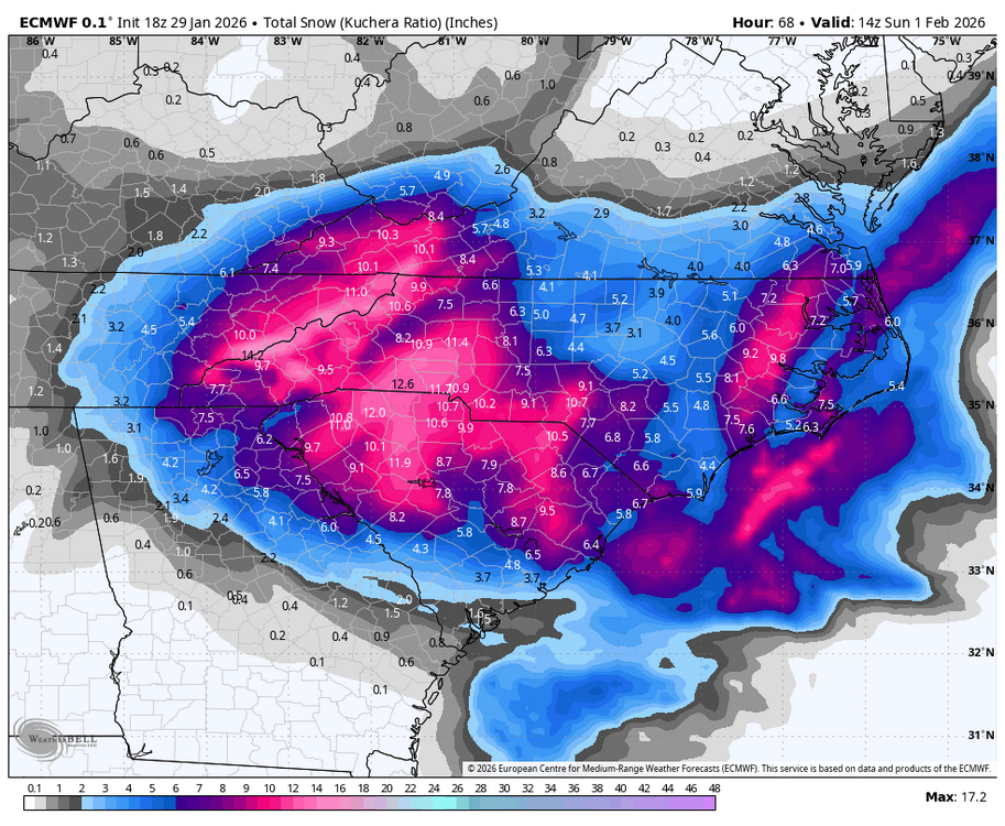
00z CMC also much better!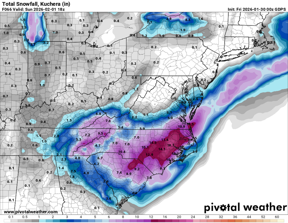
-
Richmond Metro/Hampton Roads Area Discussion
ORFDawg2013 replied to RIC Airport's topic in Mid Atlantic

-
Richmond Metro/Hampton Roads Area Discussion
ORFDawg2013 replied to RIC Airport's topic in Mid Atlantic
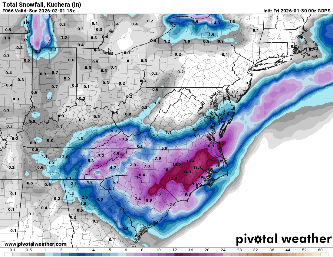
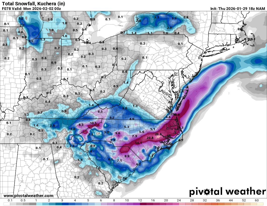
00Z GFS more NW with precip shield too! -
Richmond Metro/Hampton Roads Area Discussion
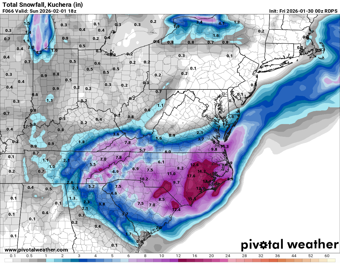
ORFDawg2013 replied to RIC Airport's topic in Mid Atlantic
RGEM = RDPS -
Richmond Metro/Hampton Roads Area Discussion
ORFDawg2013 replied to RIC Airport's topic in Mid Atlantic
RDPS moved a bit NW too at 00z
-
Richmond Metro/Hampton Roads Area Discussion
ORFDawg2013 replied to RIC Airport's topic in Mid Atlantic

-
The “I bring the mojo” Jan 30-Feb 1 potential winter storm
ORFDawg2013 replied to lilj4425's topic in Southeastern States
yeah, don't love that for SEVA -
The “I bring the mojo” Jan 30-Feb 1 potential winter storm
ORFDawg2013 replied to lilj4425's topic in Southeastern States
for real! -
Richmond Metro/Hampton Roads Area Discussion
ORFDawg2013 replied to RIC Airport's topic in Mid Atlantic
-
Richmond Metro/Hampton Roads Area Discussion
ORFDawg2013 replied to RIC Airport's topic in Mid Atlantic
18z GFS not great for SE VA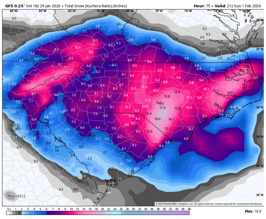
-
Richmond Metro/Hampton Roads Area Discussion
ORFDawg2013 replied to RIC Airport's topic in Mid Atlantic
I've never seen thundersnow. I would die if that were to happen with this storm! -
The “I bring the mojo” Jan 30-Feb 1 potential winter storm
ORFDawg2013 replied to lilj4425's topic in Southeastern States
Going to say pretty rare. I only moved here in 2020 so it was definitely the most I'd seen in one storm! Originally from Georgia! -
Richmond Metro/Hampton Roads Area Discussion
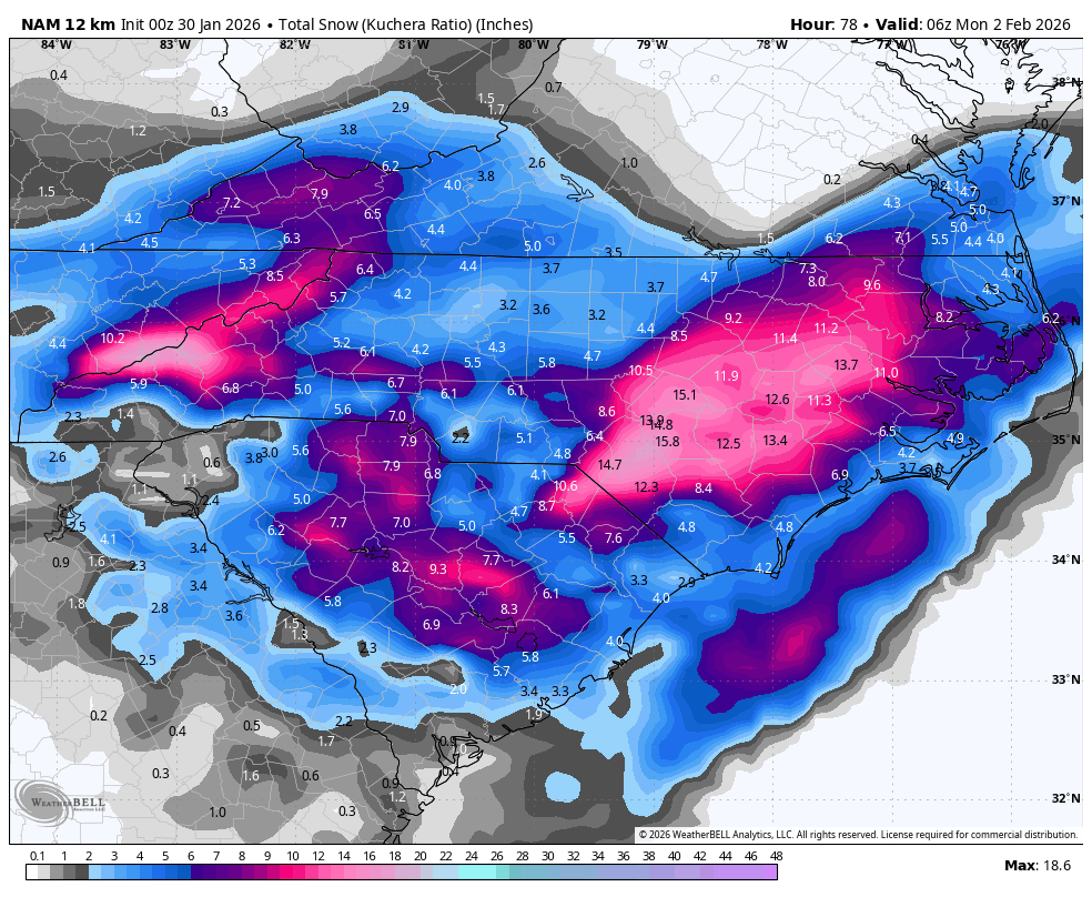
ORFDawg2013 replied to RIC Airport's topic in Mid Atlantic
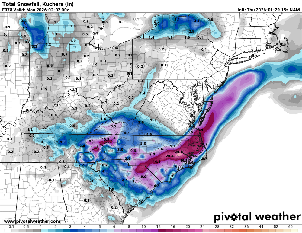
18z NAM had it snowing through 21z Sunday for HR