chris624wx
-
Posts
291 -
Joined
-
Last visited
Content Type
Profiles
Blogs
Forums
American Weather
Media Demo
Store
Gallery
Everything posted by chris624wx
-

Richmond Metro/Hampton Roads Area Discussion
chris624wx replied to RIC Airport's topic in Mid Atlantic
Allan Huffman's latest map -
Richmond Metro/Hampton Roads Area Discussion
chris624wx replied to RIC Airport's topic in Mid Atlantic
-
Richmond Metro/Hampton Roads Area Discussion
chris624wx replied to RIC Airport's topic in Mid Atlantic
Goodness. Kind of glad I'm in a 3rd story apartment haha -
Richmond Metro/Hampton Roads Area Discussion
chris624wx replied to RIC Airport's topic in Mid Atlantic
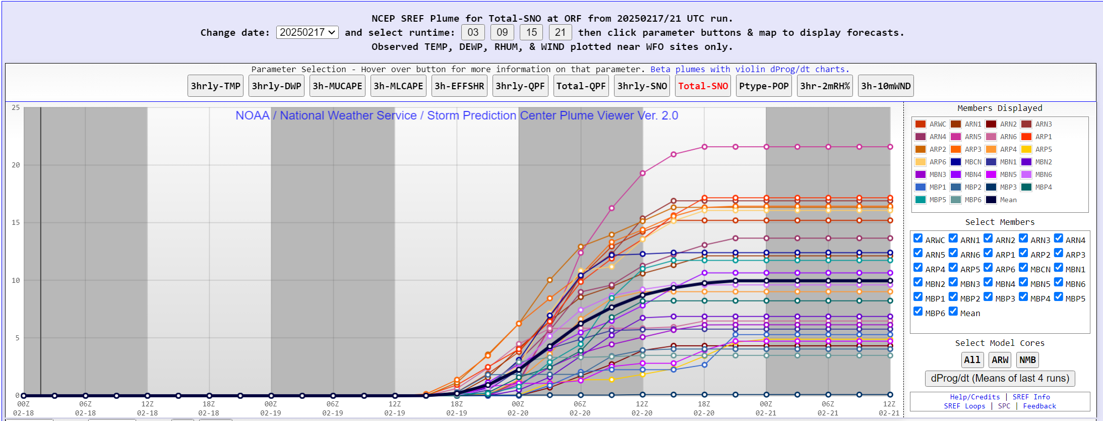
Potentially a top 10 snowfall for ORF if some of the modeling is correct. Will be interesting to see how it shakes out.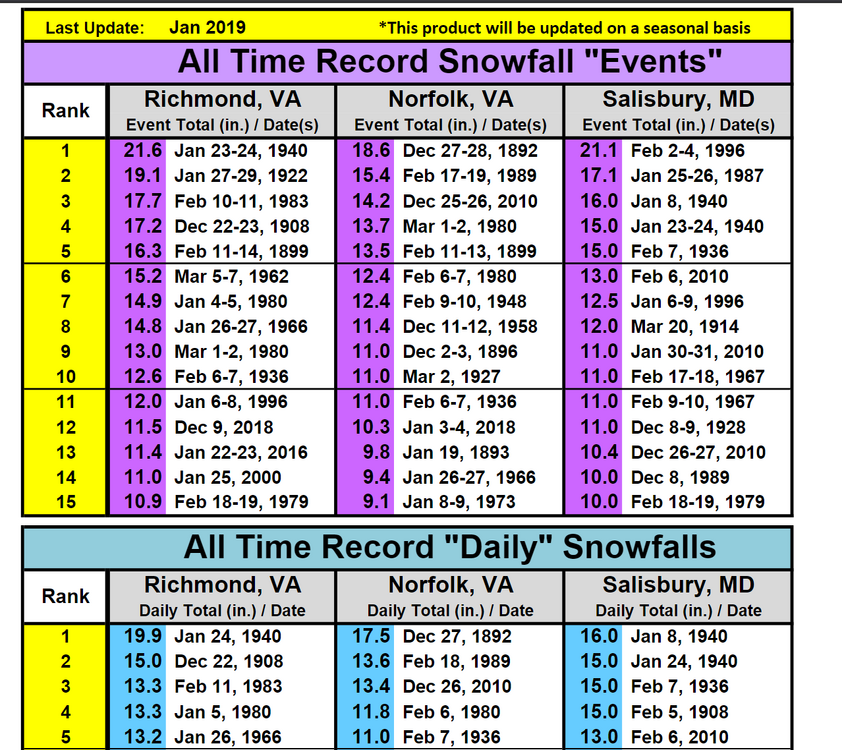
-
Richmond Metro/Hampton Roads Area Discussion
chris624wx replied to RIC Airport's topic in Mid Atlantic
GFS showing some deformation banding in Southside HR as the low pulls away too! -
Richmond Metro/Hampton Roads Area Discussion
chris624wx replied to RIC Airport's topic in Mid Atlantic
From AKQ's new AFD: 12z/17 operational models and their respective ensembles (GFS/ECMWF/Canadian) continued a solution showing lesser phasing between the southern stream system and the trailing potent northern stream mid-level trough. This drives a general S-SE trend with southern stream system and subsequent developing low pressure, with lower snow accumulations over far northern portions of the area (essentially RIC northward). Overall, forecast confidence is steadily increasing for a significant winter storm across our region Wednesday into Thursday. Ensemble probabilities have similarly settled over central and SE VA with 4+" probs (60-80+% from RIC southeast), with 6+" probs 50-70% from RIC Metro and 70-90% over Hampton Roads and southside into NE NC N of US-158. Notably 4 and 6" probs have lowered substantially (20-50% and 20-30%, respectively) above a FVX to RIC to SBY line. Precipitation Timing and Impacts... Precip spreads in from west to east through Wednesday morning, as strong WAA aloft slides across the region. Given the very cold air in place, this will set the stage for a broad swath of accumulating snows across the region. While the overall QPF has lowered across the northwestern half of the area, the initial slug of overrunning moisture (290-300 k SFCs) across the northern half of the area could well provide a strong, quick burst of snow over the NW-third of the area Wed morning into Wed afternoon, which could quick make for treacherous traveling conditions Wed morning into the afternoon across the RIC metro. Given expected higher SLRs on the preferred EPS/GEPS blend, the higher SLR will help "compensate" for the lower QPF to a degree for the actual snowfall forecast. Farther south, most of the QPF/winter wx is expected to come from 18z Wednesday through Thursday morning. The maxima for snow at this time is expected to occur along a developing deformation axis and colocated with f-gen forcing driving moisture into the DGZ, impacting (primarily) much of the Hampton Roads area and the eastern shore. Snow Totals... Given subsidence and rapid drying aloft expected from SW to NE late Wed into Thursday, expect a rather sharp gradient to snow totals, along with a rather abrupt end to snow Wed night and early Thursday afternoon. A Winter Storm Watch has been raised for Wednesday into Thursday for our entire area. Snowfall accumulations are on the order of 3-6" across MD and the VA northern neck, with 4-8" across the RIC metro into south central VA. Higher totals at this time appear to occur along that pivoting deformation band on the back side of the departing low, with 5-10" of snow forecast. Given the colder, general SE trend, ice accumulations across our area figure to be quite low. That said, the 12z/17 NAM still has a decent corridor of mixed precip across the far southern portions of our area across interior NE NC. We have maintained some ice accumulation in these areas but kept totals aob 0.10". Thursday/Thursday night... Shear axis associated with the northern stream shortwave crosses the region on Thursday, and will quite possible set off another round of light snow showers as it crosses, with additional minor snow accumulations possible. Cold high pressure builds across the region as precip exits offshore on Thursday evening. Lows Thursday night will be cold but specific values will depend heavily on where the axis of heaviest snow falls, with highs in the upper 20s to low 30s and lows likely to be in the lower to middle teens. -
Richmond Metro/Hampton Roads Area Discussion
chris624wx replied to RIC Airport's topic in Mid Atlantic
That makes me feel better -
Richmond Metro/Hampton Roads Area Discussion
chris624wx replied to RIC Airport's topic in Mid Atlantic
Wow...that's so far NW than most of the modeling! -
Richmond Metro/Hampton Roads Area Discussion
chris624wx replied to RIC Airport's topic in Mid Atlantic
788 WWUS41 KAKQ 171939 WSWAKQ URGENT - WINTER WEATHER MESSAGE National Weather Service Wakefield VA 239 PM EST Mon Feb 17 2025 MDZ021>025-VAZ075>078-085-521-522-180345- /O.NEW.KAKQ.WS.A.0005.250219T1100Z-250220T2300Z/ Dorchester-Wicomico-Somerset-Inland Worcester-Maryland Beaches- Westmoreland-Richmond-Northumberland-Lancaster-Middlesex-Western Essex-Eastern Essex- 239 PM EST Mon Feb 17 2025 ...WINTER STORM WATCH IN EFFECT FROM WEDNESDAY MORNING THROUGH THURSDAY AFTERNOON... * WHAT...Heavy snow possible. Total snow accumulations between 3 and 6 inches possible. Winds could gust as high as 35 mph. * WHERE...Portions of southeast Maryland and east central and eastern Virginia. * WHEN...From Wednesday morning through Thursday afternoon. * IMPACTS...Travel could be very difficult. The hazardous conditions could impact the Wednesday morning and evening commutes. PRECAUTIONARY/PREPAREDNESS ACTIONS... Monitor the latest forecasts for updates on this situation. && $$ NCZ012>017-030>032-102-VAZ084-086-089-090-092-093-095>100-523>525- 180345- /O.NEW.KAKQ.WS.A.0005.250219T1100Z-250220T2300Z/ Northampton-Hertford-Gates-Pasquotank-Camden-Western Currituck- Bertie-Chowan-Perquimans-Eastern Currituck-Gloucester-Mathews- Surry-James City-Southampton-Isle of Wight-Norfolk/Portsmouth- Suffolk-Chesapeake-Virginia Beach-Accomack-Northampton-York- Newport News-Hampton/Poquoson- 239 PM EST Mon Feb 17 2025 ...WINTER STORM WATCH IN EFFECT FROM WEDNESDAY MORNING THROUGH THURSDAY AFTERNOON... * WHAT...Heavy mixed precipitation possible. Total snow accumulations between 5 and 10 inches and ice accumulations of up to one-tenth of an inch possible. Winds could gust as high as 35 mph. * WHERE...Portions of northeast North Carolina and eastern and southeast Virginia. * WHEN...From Wednesday morning through Thursday afternoon. * IMPACTS...Travel could be very difficult. The hazardous conditions could impact the Wednesday morning and evening commutes. PRECAUTIONARY/PREPAREDNESS ACTIONS... Monitor the latest forecasts for updates on this situation. && $$ VAZ048-060>062-064>069-079>083-087-088-509>520-180345- /O.NEW.KAKQ.WS.A.0005.250219T1100Z-250220T2300Z/ Fluvanna-Prince Edward-Cumberland-Goochland-Caroline-Mecklenburg- Lunenburg-Nottoway-Amelia-Powhatan-Brunswick-Dinwiddie-Prince George-Charles City-New Kent-Greensville-Sussex-Western Louisa- Eastern Louisa-Western Hanover-Eastern Hanover-Western Chesterfield-Eastern Chesterfield (Including Col. Heights)- Western Henrico (Including the City of Richmond)-Eastern Henrico- Western King William-Eastern King William-Western King and Queen- Eastern King and Queen- 239 PM EST Mon Feb 17 2025 ...WINTER STORM WATCH IN EFFECT FROM WEDNESDAY MORNING THROUGH THURSDAY AFTERNOON... * WHAT...Heavy snow possible. Total snow accumulations between 4 and 8 inches possible. * WHERE...Portions of central, east central, north central, south central, and southeast Virginia. * WHEN...From Wednesday morning through Thursday afternoon. * IMPACTS...Travel could be very difficult. The hazardous conditions could impact the Wednesday morning and evening commutes. PRECAUTIONARY/PREPAREDNESS ACTIONS... Monitor the latest forecasts for updates on this situation. && $$ 05 -
Richmond Metro/Hampton Roads Area Discussion
chris624wx replied to RIC Airport's topic in Mid Atlantic
Winter Storm Watch just issued. -
Richmond Metro/Hampton Roads Area Discussion
chris624wx replied to RIC Airport's topic in Mid Atlantic
I think they're likely TO go up this afternoon. They mentioned in their early morning AFD holding off due to uncertainty. I guess we'll see how they feel about that when their afternoon package comes out. -
Richmond Metro/Hampton Roads Area Discussion
chris624wx replied to RIC Airport's topic in Mid Atlantic
Dang... -
Richmond Metro/Hampton Roads Area Discussion
chris624wx replied to RIC Airport's topic in Mid Atlantic
Don't have RIC's super zoomed in maps but yeah! -
Richmond Metro/Hampton Roads Area Discussion
chris624wx replied to RIC Airport's topic in Mid Atlantic
Okay that's more SE now than I'd like.... -
Richmond Metro/Hampton Roads Area Discussion
chris624wx replied to RIC Airport's topic in Mid Atlantic
Okay, that's juuuuuuuuuuuust enough SE trend. Let's hold it right there haha -
Richmond Metro/Hampton Roads Area Discussion
chris624wx replied to RIC Airport's topic in Mid Atlantic
Here is Allan Huffman's 1st Call Map -
Richmond Metro/Hampton Roads Area Discussion
chris624wx replied to RIC Airport's topic in Mid Atlantic
-
Richmond Metro/Hampton Roads Area Discussion
chris624wx replied to RIC Airport's topic in Mid Atlantic
I mean, I'd still take it! -
Richmond Metro/Hampton Roads Area Discussion
chris624wx replied to RIC Airport's topic in Mid Atlantic
Yeah the past couple of winters have been sad until we had the event in January 2025, which only really whet the appetite for me haha -
Richmond Metro/Hampton Roads Area Discussion
chris624wx replied to RIC Airport's topic in Mid Atlantic
Where can I sign on the dotted line? [emoji23] -
Richmond Metro/Hampton Roads Area Discussion
chris624wx replied to RIC Airport's topic in Mid Atlantic
I'm fine with fringe mixing especially once most the snow has fallen haha -
Richmond Metro/Hampton Roads Area Discussion
chris624wx replied to RIC Airport's topic in Mid Atlantic
I haven't done deep dive into the low levels but I bet the GFS soundings have a warm nose somewhere between 850-925 mb for our area. That'd be enough to knock totals down a good bit -
Richmond Metro/Hampton Roads Area Discussion
chris624wx replied to RIC Airport's topic in Mid Atlantic
Definitely hope GFS is out to lunch for us on the Southside -
Richmond Metro/Hampton Roads Area Discussion
chris624wx replied to RIC Airport's topic in Mid Atlantic
I'll take my measly 16 inches all the way to the bank! -
Richmond Metro/Hampton Roads Area Discussion
chris624wx replied to RIC Airport's topic in Mid Atlantic
God Save the King!