
CNY-WXFREAK
-
Posts
3,872 -
Joined
-
Last visited
Content Type
Profiles
Blogs
Forums
American Weather
Media Demo
Store
Gallery
Everything posted by CNY-WXFREAK
-
Upstate/Eastern New York
CNY-WXFREAK replied to BuffaloWeather's topic in Upstate New York/Pennsylvania
Sweet band just to the South of Hamburg -
Upstate/Eastern New York
CNY-WXFREAK replied to BuffaloWeather's topic in Upstate New York/Pennsylvania
You can definitely see the Ice doing a number on the bands that are trying to form, interesting! -
Upstate/Eastern New York
CNY-WXFREAK replied to BuffaloWeather's topic in Upstate New York/Pennsylvania
I'm gonna laugh when KBUF see's their 3rd event in a week, and while we're under warnings here, they'll receive more than we do guaranteed, RLMAO! Can it get any worse this yr, WOW, please let it end! -
Upstate/Eastern New York
CNY-WXFREAK replied to BuffaloWeather's topic in Upstate New York/Pennsylvania
I think KBUF easily sees a quick 4-6" before any bands drop South so we'll see! -
Upstate/Eastern New York
CNY-WXFREAK replied to BuffaloWeather's topic in Upstate New York/Pennsylvania
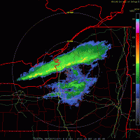
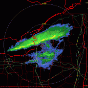
They don't even know, lol, how horrible? With the advent of cold advection this morning, model soundings are quickly shifting colder, and the unstable layer with minimally sheared flow will allow for lake effect snow bands to form underneath a more general large scale snow simply from a more efficient ice crystal growth habit in the cold advection. Light snow has developed over eastern Lake Erie and nearby portions of Ontario, amd likewise some banding of snow is noted in areas we are fairly certain that contain open water over the lake (there are mostly just to the NW of Cleveland from the GLERL analysis). However, we haven`t gotten a good look at the lake yet to better ascertain where additional banding may form from, so this update really just favors much higher PoPs for the day for snow showers over WNY and around an inch of accumulation. It does seem some banding is developing into the Southtowns as of this writing, so if we can determine there is a source for this in the lake, additional updates may be necessary. There is very definite potential for an upside surprise today in the Buffalo area, to be certain. -
Upstate/Eastern New York
CNY-WXFREAK replied to BuffaloWeather's topic in Upstate New York/Pennsylvania
Nam is weak sauce! Right over my crib is this one! all in all, not bad so we wait -
Upstate/Eastern New York
CNY-WXFREAK replied to BuffaloWeather's topic in Upstate New York/Pennsylvania
Channel 3, Wayne Mahar is horrific! wait thats channel 9, either way! -
Upstate/Eastern New York
CNY-WXFREAK replied to BuffaloWeather's topic in Upstate New York/Pennsylvania
The Upper Mid-West is gonna get crushed with storm after storm after storm so good for them I suppose but when will it be our turn for a nice synoptic run, WTF man? -
Upstate/Eastern New York
CNY-WXFREAK replied to BuffaloWeather's topic in Upstate New York/Pennsylvania
What is up with the Euro? Looks like a 2-5" event if that, lol? -
Upstate/Eastern New York
CNY-WXFREAK replied to BuffaloWeather's topic in Upstate New York/Pennsylvania
Decent 10-1 map for next week so we'll see but its definitely trending colder thats one certainty I've been observing as snows becoming the dominant type now! -
Upstate/Eastern New York
CNY-WXFREAK replied to BuffaloWeather's topic in Upstate New York/Pennsylvania
Yeah I don't know what their looking at but its something. -
Upstate/Eastern New York
CNY-WXFREAK replied to BuffaloWeather's topic in Upstate New York/Pennsylvania
Wow, I'm serious too, wowzers as the potential does actually exist for someone to cash in for sure! Look at these parameters, seriously?? OMEGA OMEGA OMEGA, yikes and it all intersects beautifully the only small caveat is the sng of course but that should be offset by super steep lapse rates and ample Synoptic moisture! By 15Z its drying out as the Cap lowers and subsidence begins in earnest! MY prediction for this event is Oswego proper Jacks. Winds start off around 275-280 and veer towards 290 slowly and as it hits its furthest point around 285-290 she stays steady state for about 3-6hrs and its during this time that whoever end up under this band will be happy campers come Sat morning and it won't be me or Wolfie but Matt up in Oswego should look out for this one, so good luck to all. Also, Tug Matt you're in a great spot as well I think as you stand the bast chance to see the band the longest so we'll see as with all these events! -
Upstate/Eastern New York
CNY-WXFREAK replied to BuffaloWeather's topic in Upstate New York/Pennsylvania
I'm down to patches of snow as most is gone and it went real fast with super AN low temps! -
Upstate/Eastern New York
CNY-WXFREAK replied to BuffaloWeather's topic in Upstate New York/Pennsylvania
it sure will , lol, as thats what I fully expect! -
Upstate/Eastern New York
CNY-WXFREAK replied to BuffaloWeather's topic in Upstate New York/Pennsylvania
When its snows here you will all know, lol! -
Upstate/Eastern New York
CNY-WXFREAK replied to BuffaloWeather's topic in Upstate New York/Pennsylvania
True, and Fridays LE will be in C to No Oswego cty, and you know this, lol! -
Upstate/Eastern New York
CNY-WXFREAK replied to BuffaloWeather's topic in Upstate New York/Pennsylvania
Euro caved to the GFS, lol! No transfer and we rain from beginning to end, I'm done, see everyone next season! -
Upstate/Eastern New York
CNY-WXFREAK replied to BuffaloWeather's topic in Upstate New York/Pennsylvania
It doesn't snow in Fulton anymore, lol! -
Upstate/Eastern New York
CNY-WXFREAK replied to BuffaloWeather's topic in Upstate New York/Pennsylvania
-
Upstate/Eastern New York
CNY-WXFREAK replied to BuffaloWeather's topic in Upstate New York/Pennsylvania
Are we not in Winter--------------------> WTF does it take these days to get a good ole fashioned Snowstorm? -
Upstate/Eastern New York
CNY-WXFREAK replied to BuffaloWeather's topic in Upstate New York/Pennsylvania
Look at how horrible the models handle low level cold air. Euro for today at 18Z had us at 41F and we sit 10 degrees colder at 31F! -
Upstate/Eastern New York
CNY-WXFREAK replied to BuffaloWeather's topic in Upstate New York/Pennsylvania
19F in Saranac Lake and its approaching 70 in DC! -
Upstate/Eastern New York
CNY-WXFREAK replied to BuffaloWeather's topic in Upstate New York/Pennsylvania
It was a joke CNY, lol! A week out still, I'll pass till Sunday evening then if it's still around then I'll start paying attention! Something to track at least, as we haven't even had that, as of late, lol! -
Upstate/Eastern New York
CNY-WXFREAK replied to BuffaloWeather's topic in Upstate New York/Pennsylvania
Needs a lot of improvements for sure cause if the 12 looks anything like this then we're in trouble! -
Upstate/Eastern New York
CNY-WXFREAK replied to BuffaloWeather's topic in Upstate New York/Pennsylvania
If the Euro, looks good., Im in!

