
CNY-WXFREAK
-
Posts
3,872 -
Joined
-
Last visited
Content Type
Profiles
Blogs
Forums
American Weather
Media Demo
Store
Gallery
Everything posted by CNY-WXFREAK
-
Upstate/Eastern New York
CNY-WXFREAK replied to BuffaloWeather's topic in Upstate New York/Pennsylvania
Noice! -
Upstate/Eastern New York
CNY-WXFREAK replied to BuffaloWeather's topic in Upstate New York/Pennsylvania
50-100 more miles to the West and its a Major event no doubt! -
Upstate/Eastern New York
CNY-WXFREAK replied to BuffaloWeather's topic in Upstate New York/Pennsylvania
I do gotta say though that I do not believe we're getting anywhere near 3-4" tomorrow into Saturday mostly due to the BL profile and the surface temps reaching the mid-upper 30's so I don't see where the NWS is getting 3-4" from. -
Upstate/Eastern New York
CNY-WXFREAK replied to BuffaloWeather's topic in Upstate New York/Pennsylvania
Wow, are the Globals trying to come to some track consensus 5 days out? That would definitely up the ante for something at least minimally significant as far as accumulations go, then the backlash of LES begins in earnest, on a WNW flow with temps nearing -15 to-18C at times, for a couple days would no doubt yield some decent totals for pretty much thew whole South Shore of the Lake. Tug always gets hit no matter the wind flow so no need to mention, lol. Waiting patiently for the Euro to arrive with a similar track and temp profile. -
Upstate/Eastern New York
CNY-WXFREAK replied to BuffaloWeather's topic in Upstate New York/Pennsylvania
Nice track for us no doubt, but how long can the GFS keep this up, lol? -
Upstate/Eastern New York
CNY-WXFREAK replied to BuffaloWeather's topic in Upstate New York/Pennsylvania
I think this maps looks like the best representation with what I think may happen wit next weeks system. Primary gets to about SW WV then pops a secondary down near the outer banks and comes right up the coast. We'll see how this wrks out during the coming days. The models are in no sort of agreement at all wrt next weeks system. -
Upstate/Eastern New York
CNY-WXFREAK replied to BuffaloWeather's topic in Upstate New York/Pennsylvania
How would it still be raining in KPIT with that surface depiction, NO WAY! -
Upstate/Eastern New York
CNY-WXFREAK replied to BuffaloWeather's topic in Upstate New York/Pennsylvania
I don't care what any model says, if that slp is to our SE by 200+ miles, we snow, simple as that! Winds would of gone N-NW by now and would usher in very cold air as well so IDK what these models are catching. -
Upstate/Eastern New York
CNY-WXFREAK replied to BuffaloWeather's topic in Upstate New York/Pennsylvania
whats the next frame look like? -
Upstate/Eastern New York
CNY-WXFREAK replied to BuffaloWeather's topic in Upstate New York/Pennsylvania
This cant happen, lol, because the heaviest part of the band is literally right over my house, lol! -
Upstate/Eastern New York
CNY-WXFREAK replied to BuffaloWeather's topic in Upstate New York/Pennsylvania
True, said this before! Perhaps we're expecting too much for this time of yr. -
Upstate/Eastern New York
CNY-WXFREAK replied to BuffaloWeather's topic in Upstate New York/Pennsylvania
Yeah this weeks LE potential went from good to so-so to straight horrific, lol, not that it was all that great to begin with but it got better for KBUF which may be the winner for this early dwindling event. I was at lest confident at one point we'd at least have snow in the air Saturday but now I'm starting to question that as well, but North of me around WOlfie and MAtt it still looks decent, and by decent I mean 2-4" if lucky! -
Upstate/Eastern New York
CNY-WXFREAK replied to BuffaloWeather's topic in Upstate New York/Pennsylvania
Agreed, unless we're getting overly enthused about a mediocre mid fall weather pattern, which may very well be the case. Unless we see where this trough for next week set's up, then we really cant pin-point any real sensible weather cause the pattern is in transition in which models are notorious for either bringing the cold to quick or too slow, so. From these eyes, the pattern is quite ripe for something significant to pop, especially early next week, but where seems to be the question, I DO NOT believe the NWS with their LP track freom Erie across LO into the St Law valley then a transfer. So esentially their expecting the primary to hang on for a very long time before transferring most of its energy earlier to the developing coastal, like down across the Delmarva, and this can be because of the still somewhat northerly positioned Jet Stream that's still in the process of dropping with natural seasonal changes. -
Upstate/Eastern New York
CNY-WXFREAK replied to BuffaloWeather's topic in Upstate New York/Pennsylvania
Any 00Z Euro Weatherbell love Wolfie or whoever else has a sub. mine don't kick in till Dec. -
Upstate/Eastern New York
CNY-WXFREAK replied to BuffaloWeather's topic in Upstate New York/Pennsylvania
What an awesome cross-polar flow regime setting up for at least a week and perhaps beyond. I also agree that, thats extremely significant cold shot for this time of year, even for around here. Rarely do we see such cold air brought in by WNW-NW flow as its usually brought in by W-WSW winds which adds to the reason of such anomalously extreme LES storms, that happen during the month of November, in and around KBUF. Sure it can happen as it is now, but its quite anomalous, but I'll take it. The 00Z GFS has just shot after shot of synoptic love and with all this cold around, with the mean trough situated where it is, means a constant W-NWnwerly flow for days but I'd bet money the winds veer enough during this shot of cold that both Watertown and Buffalo get in on the fun. If not that way, then definitely synoptically! What a pattern though. Just imagine if it was a week before Christmas, now that would be nice! -
Upstate/Eastern New York
CNY-WXFREAK replied to BuffaloWeather's topic in Upstate New York/Pennsylvania
No one wants a WSW flow, no one and unfortunately that's the way KBUF gets their blockbusters. Move to Hamburg or somewhere like that and you'll be happy. I will be in the NE thread soon as I'm moving out of this communist state, to Maine, where I'm able to live free, or simply die, lol! -
Upstate/Eastern New York
CNY-WXFREAK replied to BuffaloWeather's topic in Upstate New York/Pennsylvania
Wolfie, You now live in the Tug and by the time March rolls around, you'l be looking for a house back down here, lol! -
Upstate/Eastern New York
CNY-WXFREAK replied to BuffaloWeather's topic in Upstate New York/Pennsylvania
You talk about Tim, look in the mirror cuz, seriously. -
Upstate/Eastern New York
CNY-WXFREAK replied to BuffaloWeather's topic in Upstate New York/Pennsylvania
Off topic, but if everyone can get out and vote Tomorrow and remove thee most corrupt Governor in existence from office would be great. Even Howie Hawkins would be a better choice than Cuomo, at this Pt, lol. -
Upstate/Eastern New York
CNY-WXFREAK replied to BuffaloWeather's topic in Upstate New York/Pennsylvania
I think its pretty much a lock that we see some kind of cold air intrusion into the lower 48, but who bears the brunt of it? My bet is the upper plains but it wouldn't take much for the whole northern tier of states, including in the North East, to get in on some early Vodka cold relatively speaking of course, so I guess we gotta wait and see how the pattern change evolves. -
Upstate/Eastern New York
CNY-WXFREAK replied to BuffaloWeather's topic in Upstate New York/Pennsylvania
If the 06Z GFS is anywhere near correct, they'll be lots of smiling faces on this board, but then again, whatever does fall,wont last too long as it'll get warm at least once more, but who wants that? Not me! -
Upstate/Eastern New York
CNY-WXFREAK replied to BuffaloWeather's topic in Upstate New York/Pennsylvania
There's been an exodus from this state every year running, lol, and I'm next, lol! -
Upstate/Eastern New York
CNY-WXFREAK replied to BuffaloWeather's topic in Upstate New York/Pennsylvania
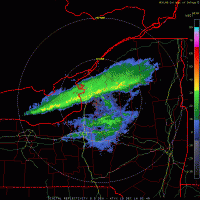
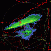
WNY is taking a pounding with rain. Nothing but yellows and dark greens to be had all across the area. What a waste of liquid, lol! -
Upstate/Eastern New York
CNY-WXFREAK replied to BuffaloWeather's topic in Upstate New York/Pennsylvania
I have noticed one thing that's quite beneficial or at least it seems this way, and that's the current/mean storm track that's been affecting the area with copious amounts of rain the last couple weeks and it doesn't look like it lets up anytime soon or at least according to most model guidance. In fact, it looks like our best chances at an area wide. first accumulating snow, but its so far out that it can change and probably will several times but its been hinting at this time frame for quite a while now. so who knows, but from about the 10th through the 17th, that time frame looks ripe for an event whether it's LES or Synoptic remains to be seen. -
Upstate/Eastern New York
CNY-WXFREAK replied to BuffaloWeather's topic in Upstate New York/Pennsylvania
Well thexn I guess we'll all see what happens at the end when we revisit the season.


