
CNY-WXFREAK
-
Posts
3,872 -
Joined
-
Last visited
Content Type
Profiles
Blogs
Forums
American Weather
Media Demo
Store
Gallery
Everything posted by CNY-WXFREAK
-
Upstate/Eastern New York
CNY-WXFREAK replied to BuffaloWeather's topic in Upstate New York/Pennsylvania
Stop worrying about when its gonna end, lol, she hasn't even gotten here yet, lol! It's gotta end some time, I just hope when she ends, we're semi satisfied with totals. -
Upstate/Eastern New York
CNY-WXFREAK replied to BuffaloWeather's topic in Upstate New York/Pennsylvania
Snow is gonna come in like a wall! -
Upstate/Eastern New York
CNY-WXFREAK replied to BuffaloWeather's topic in Upstate New York/Pennsylvania
Looks pretty heavy, lol! -
Upstate/Eastern New York
CNY-WXFREAK replied to BuffaloWeather's topic in Upstate New York/Pennsylvania
Realistic not pessamistic, never fails, lol, but the good thing is, is that he squashes all the wish casting that happens, lol! -
Upstate/Eastern New York
CNY-WXFREAK replied to BuffaloWeather's topic in Upstate New York/Pennsylvania
Glad ppl are mentioning the fact its only the 14th of NOV, lol! -
Upstate/Eastern New York
CNY-WXFREAK replied to BuffaloWeather's topic in Upstate New York/Pennsylvania
You'l be fine up in Oswego Matt! -
Upstate/Eastern New York
CNY-WXFREAK replied to BuffaloWeather's topic in Upstate New York/Pennsylvania
Somewhere in SENY, someone see's over a foot, easy! -
Upstate/Eastern New York
CNY-WXFREAK replied to BuffaloWeather's topic in Upstate New York/Pennsylvania
GGEM -
Upstate/Eastern New York
CNY-WXFREAK replied to BuffaloWeather's topic in Upstate New York/Pennsylvania
4KM -
Upstate/Eastern New York
CNY-WXFREAK replied to BuffaloWeather's topic in Upstate New York/Pennsylvania
Nam total snow 00Z valid Friday 15Z -
Upstate/Eastern New York
CNY-WXFREAK replied to BuffaloWeather's topic in Upstate New York/Pennsylvania
We already know Tim, lol! -
Upstate/Eastern New York
CNY-WXFREAK replied to BuffaloWeather's topic in Upstate New York/Pennsylvania
I guess one of them should be correct, when all is said and done, lol! -
Upstate/Eastern New York
CNY-WXFREAK replied to BuffaloWeather's topic in Upstate New York/Pennsylvania
To say the least, lol! -
Upstate/Eastern New York
CNY-WXFREAK replied to BuffaloWeather's topic in Upstate New York/Pennsylvania
Watch Niagara Cty jacks cause of some weird lake convergence band on a North Wind, lol! -
Upstate/Eastern New York
CNY-WXFREAK replied to BuffaloWeather's topic in Upstate New York/Pennsylvania
We have a nice little contest going for this event, nice! -
Upstate/Eastern New York
CNY-WXFREAK replied to BuffaloWeather's topic in Upstate New York/Pennsylvania
YYZ 3", I forgot to include Toronto -
Upstate/Eastern New York
CNY-WXFREAK replied to BuffaloWeather's topic in Upstate New York/Pennsylvania
Looks like KSYR will be way above the norm, if tomorrow's system comes to pass, and we get 8-10" or whatever. Avg for Nov is 9.6" so we'll pass that with ease, so this may be a first below norm month for both temps/snow in a while I believe! -
Upstate/Eastern New York
CNY-WXFREAK replied to BuffaloWeather's topic in Upstate New York/Pennsylvania
Wayne-Northern Cayuga-Oswego-Jefferson-Lewis- Including the cities of Newark, Fair Haven, Oswego, Watertown, and Lowville 219 PM EST Wed Nov 14 2018 ...WINTER WEATHER ADVISORY IN EFFECT FROM 7 PM THURSDAY TO 1 PM EST FRIDAY... * WHAT...Mixed precipitation expected. Total snow accumulations of 5 to 8 inches and ice accumulations of a few hundredths of an inch expected. * WHERE...Wayne, Northern Cayuga, Oswego, Jefferson, and Lewis counties. * WHEN...From 7 PM Thursday to 1 PM EST Friday. * ADDITIONAL DETAILS...Plan on slippery road conditions. The hazardous conditions could impact the morning or evening commute. PRECAUTIONARY/PREPAREDNESS ACTIONS... Periods of snow, sleet or freezing rain will result in slippery roads and limited visibilities. Slow down and use caution while driving. Submit snow and ice reports through our website or social media. && This means we're gonna get pegged, no doubt an overachiever! -
Upstate/Eastern New York
CNY-WXFREAK replied to BuffaloWeather's topic in Upstate New York/Pennsylvania
BUF 3.5" ROC 4" FUL 5" SYR 6" BGM 9" SCR 10" WTR 2" ITH 12" YYZ 3" -
Upstate/Eastern New York
CNY-WXFREAK replied to BuffaloWeather's topic in Upstate New York/Pennsylvania
Yes sir, thats whats expected to pass through so that's the area to watch to see its behavior, movement, banding potential and intensity of precip within the leaf. There may be a brief period of sleet the further north one is but from about KSYR on North this is primarilly a completely frozen event but places like KITH, KBGM and Cortland have the potential of at least 6" of snow and 1" of ice, OUCH!! BAROCLINIC LEAF. A baroclinic leaf is the name given to a synoptic cloud formation that resembles the shape of a leaf. It is the lifting exerted from the low pressure system and the warm and cold fronts that produces this cloud pattern. When air is lifted to the point of saturation, then clouds will develop. -
Upstate/Eastern New York
CNY-WXFREAK replied to BuffaloWeather's topic in Upstate New York/Pennsylvania
I really love the look of this Satellite View and it looks like to me that guidance is a bit ahead of the system, meaning the system looks a bit further West than first anticipated. If that's in fact the case, then we should expect a bit of a westward jog at 00Z or even 18Z, if all the data has been ingested. -
Upstate/Eastern New York
CNY-WXFREAK replied to BuffaloWeather's topic in Upstate New York/Pennsylvania
I agree! -
Upstate/Eastern New York
CNY-WXFREAK replied to BuffaloWeather's topic in Upstate New York/Pennsylvania
Don't think we're out of the woods just yet, and yes I remember KROC the past few yrs has done well. -
Upstate/Eastern New York
CNY-WXFREAK replied to BuffaloWeather's topic in Upstate New York/Pennsylvania
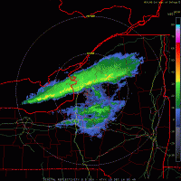
Look at this band over the Catskills, lol, what a Joke but their getting hammered! -
Upstate/Eastern New York
CNY-WXFREAK replied to BuffaloWeather's topic in Upstate New York/Pennsylvania
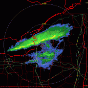
Need a subtle wind shift but lets let KROC have some fun!
