

Organizing Low
-
Posts
17,662 -
Joined
-
Last visited
Content Type
Profiles
Blogs
Forums
American Weather
Media Demo
Store
Gallery
Posts posted by Organizing Low
-
-
Steady frzra our there currently
from BTV....more frzra AND more snow , insane
.NEAR TERM /THROUGH TONIGHT/...
As of 1238 AM EST Friday...The forecast remains quite
challenging tonight and had to make several changes based on the
latest model guidance and observations. Thermal profiles on
both the global and high resolution members show a +5 to +7
degree warm nose pretty much anywhere east of the St. Lawrence
Valley. Because of this, freezing rain was added to the grids
through the overnight hours with up to a tenth of an inch of
freezing rain possible before the freezing rain changes over to
snow during the early morning hours. As it stands, it looks like
freezing rain will change over to snow between 14Z and 15Z for
Burlington, 17Z to 18Z for Montpelier and after 18Z for far
southern Vermont. Freezing rain amounts across southern Vermont
have been increased to 0.25 to 0.40 inches in response the delay
in precipitation changing over to snow this afternoon. Actually
ended up bumping up snowfall totals across northern New York and
northern Vermont based on the latest guidance. More information
to follow in the routine update between 3 and 4 AM.
-
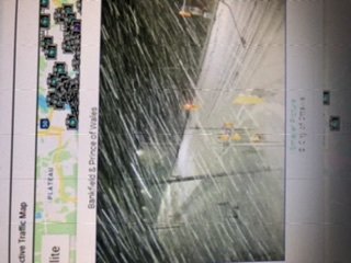
Sorry for the sideways image oops
-
Echoes came through here and were frzra
meanwhile the backside heavy snow has blossomed as modeled, and is knocking on the door in south Ottawa.
traffic cameras confirm the snow storm is getting going.
-
Those nam winds are crazy impressive on the coast. Thanks for posting dendrite.
Should be near blizzard conditions here tomorrow afternoon.
-
 1
1
-
-
Radar is blossoming just to my northwest. It’s snowing in Toronto , Ottawa and Montreal.
snow appears to be perhaps 15 miles to my northwest as the crow flies. I’m hoping that it’s not hours of tease Show , but it might be.
So close ! -
2 inches here , 23 degrees
snizzle all day and glazed windows for all
We watch the radar and wait.
-
1.5 inches here on the front end
not much to write home about as first part underperforms The 3-5 forecastthough the model trends were all over it
time for some sleep
-
7 minutes ago, WesterlyWx said:
Kuchie and 10:1


Thank you westerly !
much appreciated. -
Light snow has begun here
18 degrees.
-
If someone could post the Euro snowfall map that would be great.
my rudimentary look At free maps seems it is a bit cooler than the us models.
-
9 minutes ago, mreaves said:
BTV says 96% chance of 12”+ for St. Albans.
for sure the backside sting looks good, but I think the models have raised enough red flags to know that is optimistic at this point.
still some time for correction I suppose.
-
It’s clear what the trends are
best snows look to be in Saint Lawrence valley and not Champlain valley. South shore of Montreal down towards Vermont border and back along eastern Ontario and upstate NY. Even Ottawa is in the game all of a sudden.
Sitting in the NW most corner of Vermont I suppose my chances are better than anyone, but the amped trends do not bode well.
Would not normally be Too upset , except will be some wicked banding for this neck of the woods and was looking forward to that. Someone Just Nw of me is going to get plastered.
-
27 minutes ago, powderfreak said:
This is what you dream about.
Each run as you get closer the EURO keeps ramping it up.
Up to about 1.75-2” QPF now.

Wow
if this play out those fantasy run from the GFS that caught my attention over The Weekend will be essentially dead on.
great to be in the lolli zone
-
We had a great storm in November but this will end up being the storm of the season up in N Vermont if the GFS pans out. But the NaM and euro not so much.
I will give the GFS credit for being Generally consistent for the better part of 5 days on this one.In any case , Looks like a 2 parter, extended duration event. These days I only post when there’s potential for something memorable , so I guess I am cautiously optimistic ?
-
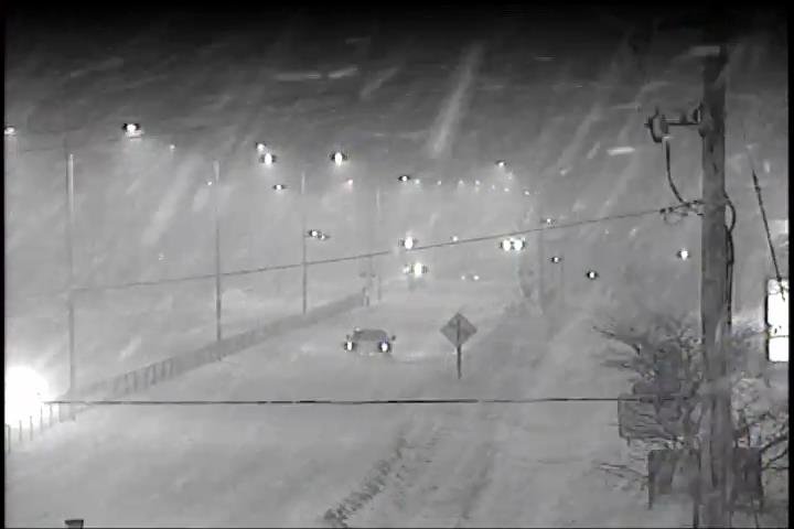
absolutely pouring in ottawa, thought i'd share a traffic cam
-
11 minutes ago, powderfreak said:
00z HRRR has a good another 0.75" QPF coming too.
Should be a nice shot of over 1" QPF storm total snow regardless of what the total is.
But damn look at the Montreal area and just north.

models were zoning in on that area for the past couple days, great skiing at tremblant!
-
mod snow, small flakes but pouring straight down, little wind
15F
2" +
-
20 hours ago, HoarfrostHubb said:
Could I ask about the significance of that event? My weenie memory is not helping me with it, and Google seemed like it was rather middling in New England
probably the prototypical SWFE upon which they should all be built....at least in my memory. and resulted in a crippling storm in ontario and quebec and atlantic canada, probably the biggest storm in recent times to affect such a large swath of canada's population.
you guys had a significant storm a few days even before that i recall. a december to remember in SNE.
-
1
-
-
heading to stowe tomorow morning and back later in the day hopefully before the snow starts up.
parents flights from ottawa to california (through YYZ toronto) tomorrow already cancelled (!) as of this morning, so that was a relief - obviously lots of hype up there for a repeat of dec 16 2007 which it wont be. still glad they cancelled the flights thanks to lots of lead time on this one.
this will just be a regular winter storm up here IMO. nevertheless 8-12 is reasonable, anything more a bonus, my call i think the sleet will push further north and eclipse BTV, although i certainly do respect the cold- but this is not looking like a dec 16/07 redux as Will has pointed out.
-
1
-
-
11 minutes ago, ORH_wxman said:
Lol...pretty close on that. Almost has Mitch pinging while the Cape is still snowing.
This is still one of my favorite sfc maps:
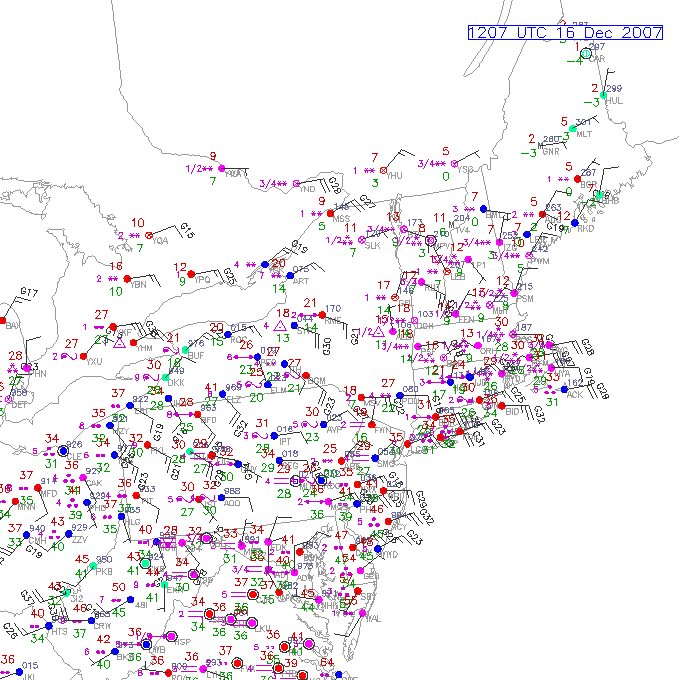
all time classic
-
3 hours ago, ORH_wxman said:
I've been on the 4-6 train here for about 2 days now.
Possible we could get 7-8 if we went insane thump for a while...but you need like 2" per hour for that and I don't see it on this setup. We'd need the whole midlevel structure of the storm about 100-200 miles east for that I think...more like 12/16/07. GFS has flirted at times with the heavier scenario but not gonna bite unless we see a collective trend toward that tomorrow.
It could be 3" too if the push is weak for the first 2-4 hours.
But regardless, def gonna be a wintry storm. Sfc ain't going above freezing over interior until around FROPA.
and there you have it
i feel in a decent position here, though on the cusp of sleet here IMO. all places SE of here including VT, would not be very confident. would like to see some better trends for all folks tomorrow.
should be another great storm for ottawa where the banks are piling high this year.
-
1 hour ago, mississaugasnow said:
long time lurker of this sub. I enjoy reading the discussions you guys have, generally when a pattern is good for you its okay for Southern Ontario. Right now I'm in a slightly better position regarding this pattern but still getting shafted by the lows all going far NW of even us here in S.Ontario.
57 minutes ago, ORH_wxman said:This front end thump looks pretty good. Still has plenty of time to trend either way but there will be some good fronto with that high position.
december 15, 2007 comes to mind
-
1
-
-
On 1/27/2019 at 7:23 PM, Albert A Clipper said:
I passed through there on the way back from salt lake last Tuesday....meh, typical Chicago in January, dreary, 26 degrees...freezing snizzle....nothing to write home about.
i was in oakabrook terrace, we got down to -5 to -10F on 2 nights. one of those days the wind in the city was just awful. that was before the cold snap, luckily i left in time.
-
i slipped on ice twice outside this evening, was surprised given we've been above freezing for about 24 hours
i guess thats the cold surface effect..


February 5-7 Wintry Mess Potential
in New England
Posted
Anddddd we snow")
coming down at a good clip already , juicy flakes
from BTV they were on it