

larrye
-
Posts
253 -
Joined
-
Last visited
Content Type
Profiles
Blogs
Forums
American Weather
Media Demo
Store
Gallery
Posts posted by larrye
-
-
6 minutes ago, NEG NAO said:
you have to keep an open mind 4 days out IMO
I don't see where anyone has said anything with 100% certainty. But you also have to be realistic based on the data that has been made available, with the trends, with climatology, and with previous history with snow events and their likely modeling trend progression. Things can change, and they probably will. People are commenting based on data 4 days out.
-
 2
2
-
-
On 9/10/2023 at 3:38 PM, Yeoman said:
There is no day 14 model prog worth mentioning
Worth mentioning when it's day 12 and the GFS appears consistent over many runs at the very least showing an EC threat. Not saying that long-range is reliable or you can draw any conclusions. Not saying it won't disappear completely tomorrow. Just sayin' it's something to watch over the next week (just as we did for Lee at that point).
-
1
-
 1
1
-
-
48 minutes ago, Hotair said:
Euro imagines a direct hit to New England from a high end category 2/ cat 3 Lee next Sunday
question is what is Euro seeing now that wasn’t evident 12 hours ago and that other models are dismissing ?
Probably a slower hurricane that just isn't getting caught up in the trough, or possibly a stronger influence from Margo?
-
9 minutes ago, olafminesaw said:
The Euro has been all over the place. Swings between missing NS entirely to the East, and a US landfall almost every other run. The GFS meanwhile has been rock steady with a landfall on NS for days now.
That's not what I recall seeing on the Euro. There were some runs a few days back where it was a hit for the Cape, but in the last few days, it's pretty much been a hit for NS (albeit usually further west than the GFS). I think it's been more consistent than you think over the past couple of days.
-
Do we still have an Omega block pattern in place and if so, any indications on the long-term models as to when we can expect a change?
-
56 minutes ago, vegan_edible said:
i got really curious to see what my local forecast was... they must be looking at something im not lmao
I think they consider "White Plains" to be HPN, which is actually about 5 or so miles north of White plains.
-
3
-
-
16 minutes ago, Winterweatherlover said:
Not trying to be negative but part of why people get disappointed and say the models stink is you trust models and model runs that shouldn’t be trusted too much. The NAM is unfortunately not a reliable at all.
It certainly consistently overstates QPF.
-
1
-
-
Preface by saying I'm not a met. But I DO know that the NAM usually overstates QPF and must always be taken with a grain of salt. The fact that there is some validation from the ECMWF makes me raise an eyebrow, though. But I wouldn't get too excited based strictly on the NAM.
-
1
-
-
5 hours ago, snowman19 said:
Hard to believe it’s a week into November and we are tracking a tropical cyclone event possibly impacting our area lol
I was wondering if anyone would notice this.
-
Anybody care to comment on the 00z GFS solution for Ian? Seems to drive the remnant low inland over the NC/VA area. Then it appears to spurn a secondary low off the coast on Sunday, and then either another one on Tuesday or it's actual the remnant low that strengthens off the coast? 00z Euro seems to do something similar.
-
1
-
-
Some chatter out there about a possible tropical low developing in the Atlantic next week:
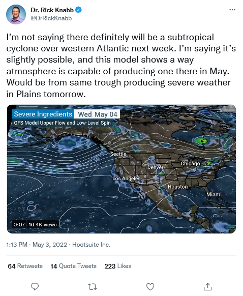
https://twitter.com/DrRickKnabb/status/1521538363106471941?s=20&t=RA2iZe897rOAe7xSAJpJqQ
-
1
-
-
5 hours ago, Tatamy said:
Consensus of the models so far is that this event would be primarily a sleet/ice event going over to rain for most in the metro. Better chances of accumulating snow would be north of I287. Of course a lot can and will change. As always be very careful with clown maps with this type of setup as they will overstate snow amounts.
"Be careful with clown maps" here is like saying don't do drugs to an addict.
-
2
-
 1
1
-
-
2 hours ago, HVSnowLover said:
I didn't know the final outcome of a storm is decided 3 days out.
Final outcome of WHAT storm? There never really was any model that with any consistency indicated anything beyond a few inches for the NY metro. There was never any solution that truly bombed out near or right inside the benchmark. At least for the storm last week, there were some consistent indications at this point (72 hours ahead of time) even though there were variations in the solutions.
Look, technically, you're right. There's always a chance. You never know. But you never know if the Yankees are going to win a ballgame on any given day either. -
15 minutes ago, HVSnowLover said:
Im just surprised how disappointed people were with 8-16 inches of snow from that storm from NYC and points east.
When people are screaming 35" on Long Island and at 1'-2' in the NY Metro and it doesn't happen, you're going to have a certain group of people that call them out on it. Face up to it.
-
 1
1
-
-
31 minutes ago, Franklin0529 said:
It's way to far east with the surface an still drops 4" in NYC an more down the beaches. H5 was much better
You're dreaming. I see 1"-2" in NYC and you're forgetting about the frontal passage.
-
16 minutes ago, Monmouth_County_Jacpot said:
Look at h5 not just the surface.
Here we go again with H5 with no surface support.
-
13 minutes ago, Franklin0529 said:
Gfs looks great
Huh? The surface is OTS with a possible brush of LI.
-
12 minutes ago, eduggs said:
Yeah I saw that. H5 looks potentially promising even though ensembles are unexciting. The 12z CMC has it too. Too bad it's so far out.
I'm actually hoping it slows down a day cause I have a flight out to FL that day :-), but the GFS has had it off and on for a few days now and it's stuck with 2/14. So I guess we'll see.
-
1
-
-
35 minutes ago, eduggs said:
I hate this winter. Still waiting for a solid snow and nothing promising to track. Monday doesn't have much of a ceiling. The wettest models (and ens individuals) are rain. It's a lousy setup. Maybe interior SNE and especially NNE has a shot.
I know it's far out. But at a glance, the GFS seems to hint at something around 2/14, although the Euro seems to push it OTS. I didn't take a look at the temps - are they too warm?
-
I'm pretty sure the temp on my Echo devices are fed from the Westchester County Airport even though it says "Tarrytown", but in the past half hour, it dropped from 42 to 28. Wow.
-
49 minutes ago, HVSnowLover said:
The models actually did well with the kuchera ratios for this storm I think. I can't imagine we got that much liquid.
So let's see when the storm finishes if there are any towns in Nassau Co with 35".
-
1 hour ago, BxSnowWx37 said:
The gfs was on vacation here,just god awful..it had me at barely 2 inches..im approaching 8+ could be more..still snowing hard btw..

You can't necessarily take model outputs literally. Go look at the forecasts for NWS, and for any of the local TV stations and you will see that none of them reflect literally any of the model outputs. The GFS nailed the "eastward" bias of the storm and the Euro was kind of hinting at it all week long also.I believe both the GFS and the Euro (and the NAM also) showed the dual surface lows. Most Mets will use their experience, model outputs, climatology, etc and come up with a blended forecast ... unless a model output is so outlandish that it looks to be an outlier when they will just discard it.
-
1
-
-
8 minutes ago, weathermedic said:
Models that depicted two centers of circulation were not that far off from this pic
Isn't this exactly what the models depicted? What happened to the claims that the surface depictions never properly reflecting the H5 levels? I think it's turning out that the models were pretty accurate. And the models ... including the Euro at the surface ... were really depicting this all week long. An eastern biased storm with highest accums over eastern LI, RI, and eastern MA ... for the most part not anywhere near the Kuchera maps ... with lesser amounts as you travel west towards the city and N&W.
-
2 minutes ago, wishcast_hater said:
This is happens pretty much EVERY big storm - it always starts with "it's not looking good" and then BAM.
Sometimes yes, sometimes no.
Snow Friday 1/19/24: is it a period of light snow (less than 2"), or is there a chance of a 5" swath in part of the NYC subforum? Event OBS.
in New York City Metro
Posted
At some point, there will be an "official forecast" of accumulations. While I agree with you in terms of trying to "microanalyze" what they are going to be, I assume you're not trying to say that we have no clue at this point? It would appear to be a light/minor event (at least at this point) with likely accumulations perhaps 1"-3" for the general area? Am I wrong?