
CoalCityWxMan
-
Posts
677 -
Joined
-
Last visited
Content Type
Profiles
Blogs
Forums
American Weather
Media Demo
Store
Gallery
Everything posted by CoalCityWxMan
-
Long range NAM doesn’t look terrible for much of central/N IL when you think about how awful this season has been
-
February 4th-7th Winter Storm Potential
CoalCityWxMan replied to Thundersnow12's topic in Lakes/Ohio Valley
Reelin er in -
January 22nd-25th Winter Storm Potential
CoalCityWxMan replied to Thundersnow12's topic in Lakes/Ohio Valley
Yeah if this can continue for awhile might get some decent totals -
January 22nd-25th Winter Storm Potential
CoalCityWxMan replied to Thundersnow12's topic in Lakes/Ohio Valley
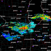
Coming down and accumulating nicely in Dekalb now -
January 22nd-25th Winter Storm Potential
CoalCityWxMan replied to Thundersnow12's topic in Lakes/Ohio Valley
Here we go! -
January 22nd-25th Winter Storm Potential
CoalCityWxMan replied to Thundersnow12's topic in Lakes/Ohio Valley
Yeah filling in sooner than i thought it would -
January 22nd-25th Winter Storm Potential
CoalCityWxMan replied to Thundersnow12's topic in Lakes/Ohio Valley
Still liking the Dekalb area for max totals based on where the band will likely pivot -
January 22nd-25th Winter Storm Potential
CoalCityWxMan replied to Thundersnow12's topic in Lakes/Ohio Valley
00z NAM coming in HOT for Friday night/Saturday it appears. Wow -
January 22nd-25th Winter Storm Potential
CoalCityWxMan replied to Thundersnow12's topic in Lakes/Ohio Valley
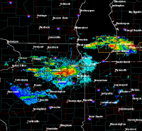
Some pretty good returns (up to 50dbz) in central IL, could translate to some good rates further north. -
January 22nd-25th Winter Storm Potential
CoalCityWxMan replied to Thundersnow12's topic in Lakes/Ohio Valley
Hello there, 31 hour RAP!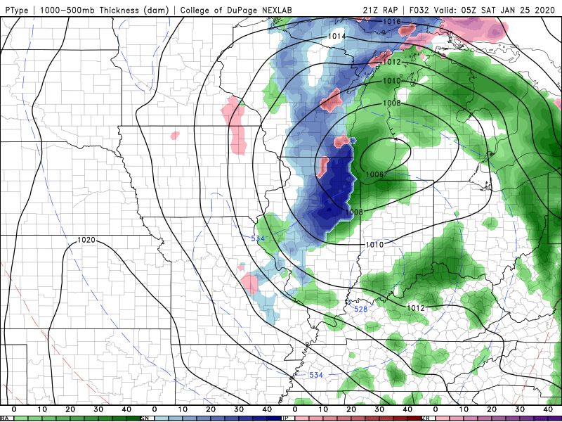
-
January 22nd-25th Winter Storm Potential
CoalCityWxMan replied to Thundersnow12's topic in Lakes/Ohio Valley
The hrrr has been coming in colder/snowier with each run tonight for N IL away from the lake (sorry Alek) -
January 22nd-25th Winter Storm Potential
CoalCityWxMan replied to Thundersnow12's topic in Lakes/Ohio Valley
At the moment the EPS/NAM/GEFS all have a bullseye almost right over Dekalb it seems. Will be interesting to see how much the favored area ends up getting -
January 22nd-25th Winter Storm Potential
CoalCityWxMan replied to Thundersnow12's topic in Lakes/Ohio Valley
Did the NAM break? -
January 22nd-25th Winter Storm Potential
CoalCityWxMan replied to Thundersnow12's topic in Lakes/Ohio Valley
If the NAM is right, Friday could be a fun day -
January 22nd-25th Winter Storm Potential
CoalCityWxMan replied to Thundersnow12's topic in Lakes/Ohio Valley
Lock in the 12z NAM -
January 22nd-25th Winter Storm Potential
CoalCityWxMan replied to Thundersnow12's topic in Lakes/Ohio Valley
Extrapolate the NAM and it’d likely be a nice long duration hit for most of N IL -
January 22nd-25th Winter Storm Potential
CoalCityWxMan replied to Thundersnow12's topic in Lakes/Ohio Valley
What’re rates looking like... .1” /hr? -
Autumn/Winter 2019-2020 Banter/Complaint Thread
CoalCityWxMan replied to IWXwx's topic in Lakes/Ohio Valley
Can’t wait for rain followed by subzero temperatures 24 hours later! -
Winter 2019-20 Medium/Long Range Discussion
CoalCityWxMan replied to Hoosier's topic in Lakes/Ohio Valley
Excited for the prospect of another .4” of snow after the .3” we had yesterday -
Reconsider majoring in meteorology!
CoalCityWxMan replied to stormguy80's topic in Weather Forecasting and Discussion
So I just stumbled across this thread, I’m going to Northern IL University in a month for meteorology and I keep seeing things like this that really want to make me reconsider. I know this was posted 8 years ago so I’m sure things have changed but if anyone has any insight into this I’d love to hear it, giving myself some other options just Incase sounds like the best bet to me right now but I’d love to hear any advice anyone may have.

