

495weatherguy
-
Posts
957 -
Joined
-
Last visited
Content Type
Profiles
Blogs
Forums
American Weather
Media Demo
Store
Gallery
Posts posted by 495weatherguy
-
-
26 minutes ago, Sundog said:
We're getting used to North Carolina averages. I didn't think it was that warm either until I saw bluewave's numbers and I was shocked. And that's up against the fake new normals that constantly go up every 10 years.
The wind has been relentless as well.
A few sunny 75 degree days with out wind would feel great
-
 1
1
-
-
3 minutes ago, bluewave said:
Top 10 warmest start to March across the region. Most spots are running +4 to +7. It’s just goes to show when we get a few months a little colder than average that the rebound warmer has been more impressive during recent years.
SMQ…+5.4°
FWN..+6.7°
EWR…+5.8°
NYC….+4.1°
LGA…..+3.8°
JFK……+6.1°
HPN…..+4.4°
BDR……+4.2°
ISP…….+4.8°
POU…..+5.1°
BGM…+6.9°
PHL…+5.8°
Definitely does not feel like a warm March on Long Island.
-
12 minutes ago, uofmiami said:
Snow mixed with rain in N Syosset. 36.5 currently.
Same mixture in Melville
-
1
-
-
2 minutes ago, MJO812 said:
This is disgusting for October 31. Im outside handing out candy in shorts and short sleeves.
80 degrees here
Awesome weather!
-
 1
1
-
 1
1
-
-
38 minutes ago, Brian5671 said:
Going to be a mega torch once that moves east. 80 for Halloween anyone?
Let’s hope!
-
1
-
 1
1
-
-
2 minutes ago, jm1220 said:
Few drops here.
No drops yet in Melville
-
6 minutes ago, psv88 said:
Yes we have had very few cool days lately. The cool downs are still 85-87
And I don’t think we have had nearly the heat NJ has enjoyed
-
1
-
-
25 minutes ago, psv88 said:
77.0 here this month, which is about the same as the last 3 years as well.
Remember how cool the 1st week of July was on LI? Seems like a lifetime ago. Big recovery to get to 77
-
1
-
-
19 minutes ago, lee59 said:
Another decent day here. High was 82 with a nice sea breeze. Now a comfortable 72
Very comfortable here in Melville as well. 72 and it feels cool
-
20 minutes ago, JetsPens87 said:
I just like it cause it upsets @MJO812 and @nycwinter and some people seem to get so bothered that people like hot weather.
Those same 2 I just tagged always try to gloat about cold and rain (had to listen to them all March and April) so now it's payback time.
I also like it for the beach and pool. Unless you have a heated pool it sucks getting in when it's only 75 to 80. When it's 90...its the best.
Very well said!
Bring on Summer!
-
2
-
-
29 minutes ago, JetsPens87 said:
As expected latest GEFS now washout any trough in the E completely and may even be hotter than the EPS now.
Turning up the heat it appears
-
7 minutes ago, Dark Star said:
Seems to be even more difficult today, despite all the technology.
I agree. But one thought I always come back to is that it is really difficult to get real, prolonged winter weather around here. As someone who grew up in the largely snowless winters of the late 70’s and 80’s(save for a few storms)I am reminded of an explanation I heard from a meteorologist regarding cold and snow around here. Plainly put, it’s really difficult due to the maritime influence on our weather. I’m sure there are technical reasons which I do not know about or understand, but that’s it in a nutshell. Lots of factors have to fall into place. But we seem to have gotten away from the mindset after the very snowy early 2000’s. Seems to me that we had an incredible streak that was just not sustainable from a climate perspective. My .02 I know now is not the time to be discussing winter, but the mindset is the important thing to remember here. We have to be realistic in our expectations
-
1
-
-
5 minutes ago, Stormlover74 said:
To be fair most indicators pointed to a mid Feb pattern change. Too many people assumed it was a guarantee though. I also did quite well from those 2 storms mid month even though we had very little cold air everything went right
I understand. Predicting weather is incredibly difficult, especially winter/snow in the greater NY area. Seems the desire to pull followers trumps reality
-
10 minutes ago, JetsPens87 said:
Understandable. It's always tough long range to be honest. Once we got out of the one week period in Jan I always felt winter was over and there were others who did also.
Doesn't make them more or less right this go around for predicting heat but the big indicators are all there and pretty convicted on it. I don't recall ensembles ever really bringing anything too promising inside of 2 weeks last winter. The heat starts to build next weekend.
Its coming.
Understandable. Seems to me that people like to make bold predictions to increase their followers. You were one of the more sensible people with respect to winter. You followed your training, rather than try to put your desires ahead of what was being shown. Thanks for responding. I always enjoy your discussions
-
1
-
 1
1
-
-
23 minutes ago, JetsPens87 said:
The GEFS shows how it's done (though it's quickly moving away from it).
It dives the trough in similar to the EPS in the W but maintains troughiness in the E (it would be hot but not incredibly so like the EPS). EPS washes out the W ATL trough much quicker than the GEFS which jives well with the AN SST pool off the Atl coast and the higher heights towards Greenland and NATL.
Other than that...not much. It's beyond true backdoor season by then so it would take a large scale pattern disruption to derail this at this point (e.g trough not diving into the W at all) but there is virtually no support for that outcome left.
The reason I ask is that other posters were certain of winter weather patterns, always a week or 2 away. Obviously that never occurred(thankful tbh). I say bring on the heat.
-
1
-
-
4 minutes ago, JetsPens87 said:
I'm telling you right now if you get the trough diving into the W like ensembles are showing it is going to push that heat our way and there will be places that hit 100. Only saving grace is there hasn't been a massive heat build to date yet.
It's coming.
What, if anything could derail this?
I admire your confidence in your call for heat this summer.
-
1
-
-
On 11/30/2023 at 7:44 AM, SnoSki14 said:12 minutes ago, bluewave said:
I know people hear terms like MJO, PDO, El Niño, La Niña, etc and it can get lost in the translation. So a simplified version is using the term marine heatwaves. These are just blobs of much normal than normal ocean temperatures. Unfortunately as the planet warms, most of the heat actually goes into the oceans. So we have many warm blobs in the tropical and subtropical oceans.
Since the Pacific is the largest body of water on the planet and lies just west of North America, it exerts a super sized influence on our weather. Thunderstorms gravitate to the areas of warmer waters. These create giant atmospheric waves which influence where the ridges and troughs will set up. Sometimes, we get standing waves that get stuck and drive more extreme patterns here of mostly warmth but on rare occasions cold.
Unfortunately, when the Central to Western Pacific basin is much warmer than other regions, the thunderstorms line up there. And thunderstorms in those regions drive warmer patterns for us. It also also been one of the fastest warming regions of the planet. So this is why people have been referring to La Niña background state.
When the MJO is active like it is now in the warmer phases, it can take a longer time getting to cooler phases since the Western Pacific is so warm. The MJO numbers are just regions on a map where the thunderstorms are concentrating. Plus when you have convection firing in multi warm regions like we have now, it can come out more as a chord than an individual note.
So all these factors in recent years have been conspiring to making the Pacific Jet stronger than average which in term floods North America with mild Pacific air like we are seeing this month and many other recent ones.
Thank you for the explanation!
-
5 minutes ago, Brian5671 said:
not too much though or it's 2/5/10 all over again...
Hoping for this at the least
Prefer a winter like last though
-
1
-
 1
1
-
4
-
-
-
-
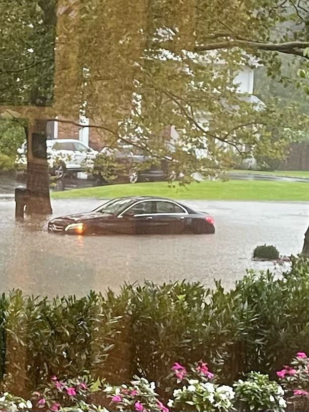
7 minutes ago, jm1220 said:
That was on a different model-HRRR. The “bullseye” might really be anywhere in our sub forum but even if not there it looks to be a much bigger area of 2-3”+ rain.
ok--appreciate the clarification--hoping the huge totals never materialize.
-
1 minute ago, jm1220 said:
New UKMET has 10.5” rain at Islip, looks just like Aug 2014 again with amounts/distribution. Upton should really be issuing watches soon.
Earlier you mentioned the big totals of rain were around Farmingdale/Bethpage; now it appears as though the "bullseye" is bit further east-Islip. Would it be reasonable to assume that the "bullseye" can continue to move east and ultimately off shore?
-
3 minutes ago, uofmiami said:
Agreed. It could 50-100 miles east or west, just have to watch radar as the storm unfolds. Hopefully it happens out to sea, so no one has to deal with the flooding that would accompany those totals.
Amen!
-
1 minute ago, jm1220 said:
On these models other than GFS, someone seems to get absolutely blasted. It seems like where it starts out gets blasted the worst but over the day it pivots east, so even on the NAM where NJ/upstate get the heaviest amounts, we all get 2-3” as the rain pivots east. I’m hoping the GFS has a clue.
2-3" is suboptimal for sure, but its way better than half a foot of rain
March 2025
in New York City Metro
Posted
Agree-time to move on to nice weather
Any idea when Long Island can get some 60’s and 70’s consistently? These 50 degree days are getting old…