

janetjanet998
-
Posts
6,027 -
Joined
-
Last visited
Content Type
Profiles
Blogs
Forums
American Weather
Media Demo
Store
Gallery
Posts posted by janetjanet998
-
-
The TUS/BHM cell is really ramping up again
-
In an event like this, deaths are inevitable. Some people can't heed the warnings because they live in a mobile home and dont have any mobility. Others are just unlikely - debris can blow into a basement and trap/kill an occupant.
Think about all the places hit today...
Tuscaloosa
Huntsville
N Birmingham
Newton
Hackelburg
Phil Campbell
Add to this list pls...
cullman ,,,,the first live tornado
-
Jasper TN
intense couplet heading for the city
-
It's a mile wide wedge, it takes a lot longer then just a few minutes for one to cycle, Birmingham is screwed.
no its not...it will go north of the city and the north side isn;t that populated not near as the south side ..another 2-3 miles south would be a complete disaster
but decent size towns in its path
-
BHM storm may be truning very tad right not good North side of BHM along and north of the interstate looks to be in trouble
-
FYI supercells developing over NC and VA too
-
may stay just north of BHM city
BULLETIN - EAS ACTIVATION REQUESTED
TORNADO WARNING
NATIONAL WEATHER SERVICE BIRMINGHAM AL
531 PM CDT WED APR 27 2011
THE NATIONAL WEATHER SERVICE IN BIRMINGHAM HAS ISSUED A
* TORNADO WARNING FOR...
JEFFERSON COUNTY IN CENTRAL ALABAMA...
NORTHERN SHELBY COUNTY IN CENTRAL ALABAMA...
EAST CENTRAL TUSCALOOSA COUNTY IN WEST CENTRAL ALABAMA...
* UNTIL 630 PM CDT
* AT 531 PM CDT...STORM SPOTTERS AND THE NATIONAL WEATHER SERVICE
WERE TRACKING A LARGE AND EXTREMELY DANGEROUS TORNADO ON THE GROUND
NEAR BROOKWOOD...OR 12 MILES EAST OF HOLT. DOPPLER RADAR SHOWED
THIS TORNADO MOVING NORTHEAST AT 55 MPH.
* LOCATIONS IMPACTED INCLUDE...
BESSEMER...HUEYTOWN...HELENA...FAIRFIELD...PELHAM...HOOVER...
VESTAVIA HILLS...HOMEWOOD...BIRMINGHAM AND CHELSEA.
-
not total destruction at hospital..just windows blown out etc
-
anyword on the north BHM cell Parrish and Corava areas?
-
this thing better cycle or it will run right thru the teeth of Brimingham worst possible direction since the city is strung out SW to NW
-
large Tornado hitting Huntsville AL at this time
-
live tornado here too near huntsville
-
thats got to be a mile wide I think you can make out the wedge in the rain at times
-
Parrish and Cordova couplet moved right over the towns
-
Nashville TN
BULLETIN - EAS ACTIVATION REQUESTED
TORNADO WARNING
NATIONAL WEATHER SERVICE NASHVILLE TN
422 PM CDT WED APR 27 2011
THE NATIONAL WEATHER SERVICE IN NASHVILLE HAS ISSUED A
* TORNADO WARNING FOR...
SOUTHERN DAVIDSON COUNTY IN MIDDLE TENNESSEE...
NORTHERN WILLIAMSON COUNTY IN MIDDLE TENNESSEE...
* UNTIL 445 PM CDT
* AT 420 PM CDT...NATIONAL WEATHER SERVICE DOPPLER RADAR INDICATED A
SEVERE THUNDERSTORM CAPABLE OF PRODUCING A TORNADO. THIS DANGEROUS
STORM WAS LOCATED NEAR FAIRVIEW...OR 12 MILES WEST OF FRANKLIN...
AND MOVING NORTHEAST AT 75 MPH.
-
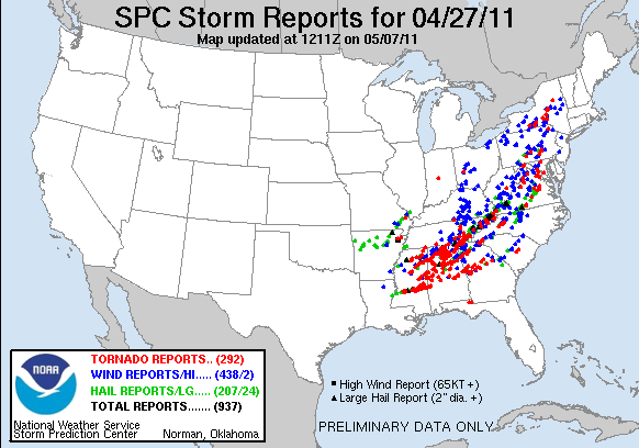
Could this event go down as one of the biggest outbreaks in recorded history for the southeast?
Yes...again it started last night in Texas..same outbreak...Non=stop tornado warnings..and many reports no gaps in conformed tornadoes
150 tornadoes seems possible..many wind damage last night will be confirmed to be tornadoes
-
Agreed, currently 33 separate tornado warnings, many for multiple counties. I don't remember the last time I've seen this. Unbelievable.
and they out number t-storm warnings 2 to 1..shows how discrete the storms are..
this is the worst outbreak i have ever followed even in the plains and I also recall following the April 1998 AL event from the NIU weather lab , and this is over more populated areas then the plains and this is rare even there,,,,,and if storms stay disrete many more hours of this
history in the making
-
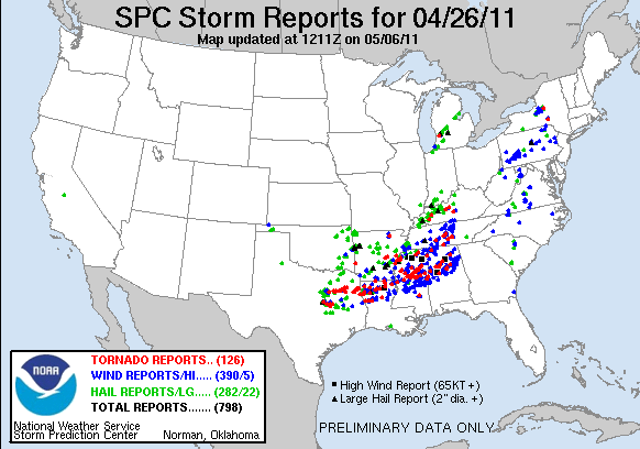
the april 26-27 outbreak continues...non stop 36+ hour outbreak....many towns some large taking direct hits
it is likley that current tornadoes are overlapping paths from this morning
western TN and westenr KY now getting unstable...TOR warned storms to the west...still TOR warned storms over eastern TN..and MS/AL I have no words
-
time to save the current columbis MS radar shot(reflect)
wow
-
Hackleburg, AL just got rocked, dBZs in the debris ball spiked to 65 when the tornado went through town. Gut wrenching feeling to say the least.
confrime: moving through downtown
-
That thing has moments where it looked like Andover and moments where it looked like Xenia. We were watching here at VU and I think all our jaws dropped.
yep..it was wider then it looked too...just no dirt like the plains to fill up the outside,,you can see small debris clouds on the outer edges away from the funnel
-
Tornado on ground in Hamilton, AL.
not good
power out and NOAA radio down from storms this morning
-
every cell when it hits about 50 dbz starts to rotate now matter how small,,amazing
-
courthouse in Downtown Cullum took a direct hit
mean that sucker went though most of the city(p0p 13000)
Historic Tornado Outbreak April 27, 2011
in Weather Forecasting and Discussion
Posted
large dangerous Tornado will affect south BHM metro
it is a 1/2 mile wide
hopefully those storms will disrupt it