

SouthBuffaloSteve
-
Posts
2,617 -
Joined
-
Last visited
Content Type
Profiles
Blogs
Forums
American Weather
Media Demo
Store
Gallery
Posts posted by SouthBuffaloSteve
-
-
38 minutes ago, BuffaloWeather said:
Think it’s time for last Jeb walk of the year. Heavy stuff about to move through.
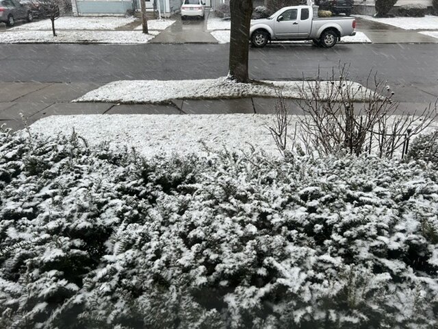
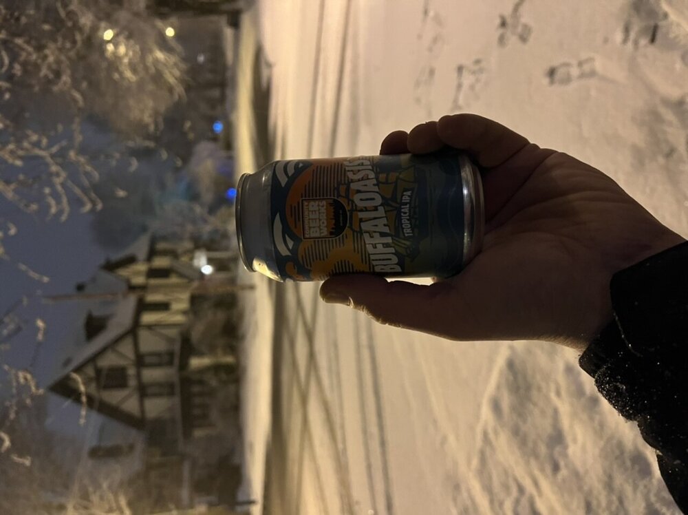
dont look all that impressive here out the window... but like you said probably the last one of the year, might as well grab a beer and go for a stroll.
-
 1
1
-
-
Getting there! Need that sun gone.
-
2
-
-
That area enhancing over Ontario should slide towards BUF a little after sunset tonight. Feeling our window to achieve will be from 7pm on until early morning Saturday. Really going to depend where that enhanced area wants to setup and persist the longest and how efficiently accumulation can begin at lower elevations near the lakes. Maybe we can sneak out some juicy meso bands later tonight.
-
22 minutes ago, BuffaloWeather said:
Snow has started here
Went from drizzle to rippin fatties in the blink of an eye.
-
3
-
-
Starting to see that enhanced area of precip over WNY blossom. Temp is dropping down to 37 now. See how quick we can changeover later this afternoon.

-
2
-
-
2 minutes ago, rochesterdave said:
Pretty lackluster stuff. I guess we’ll take what we get.
Every single one of those outputs just showing this sad valley of snowless despair right up the Genesee River into Rochester.
-
2
-
 2
2
-
-
16 minutes ago, Thinksnow18 said:
NAM seems to have gone rogue with the Far East solution…my thoughts are the overrunning event Friday night had more juice than previously modeled
agreed, looks like our best chance is actually 6pm Friday - 6am Saturday. p type and how fast until it can start to accumulate will be the key.
-
2
-
-
50 minutes ago, rochesterdave said:
Pretty good look. We need a tick west though.
We are within 84 hours now... The Jamestown magnet is back online to pull her west!

-
2
-
7
-
-
19 minutes ago, Buffalo Bumble said:
Can’t copy/paste it right now but BUF’s late evening disco is an interesting read. “Potent”, “phase” and “”bomb” all included in the same paragraph. They’re clearly on notice.
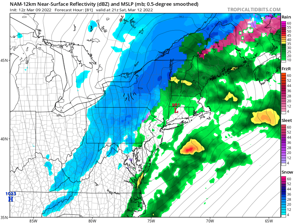
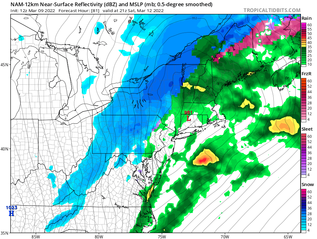
.LONG TERM /FRIDAY THROUGH MONDAY/...
Friday looks like the calm before the storm...at least the first
half the day.  Several pieces spread out over portions of the conus
that will come together to make for a potentially potent weekend
storm system. A potent upper level trough and low over the
southwestern US and Southern Rockies tracking mostly due east, a
potent trough over the southern Canadian Prairies tracking
southeast, and a weak disturbance over the Gulf of Mexico with high
moisture content. As the two troughs track toward the Tennessee
Valley from Friday morning through Saturday morning, an area of low
pressure will form over the lower Mississippi Valley ahead of the
southern trough on Friday evening, picking up the moisture from the
GOMEX disturbance. With the amplitude of the southern trough the
area of low pressure will track north-northeast along the western
side of the Appalachians. As the two troughs phase over the
Tennessee Valley, the area of low pressure will begin to rapidly
strengthen over the Ohio Valley and WNY, potentially bombing out.
Rapid deepening seems especially possible between the Tennessee
Valley and the St. Lawrence Valley, where some guidance is
suggesting pressure drops of ~30 mb in 18 hours. Currently, guidance
is tracking this system northeast over a few different areas, the
GFS is directly over WNY, the Euro over CNY, and the Canadian over
ENY. Track of the storm will be key in the potential for rain vs.
snow, and how windy it may get for Western and North Central NY. For
now going with a slightly more east solution, resulting in a bit of
a quicker change over from rain to snow, with likely POPs from late
Friday evening through Saturday morning. There are a lot of parts to
this storm scenario, and any changes in location or timing for the
different parts mentioned above will have the potential to cause
significant changes to the forecast.
-
 1
1
-
-
20 minutes ago, DeltaT13 said:
If only this storm was a touch stronger or still deepening and this would have been a very significant event. So close! Still a great day for a wind lover.
Crazy the negative impact the cold lake had in Buffalo. Been down on the water front since 230 and nothing more than breeze 10-15mph tops. Packed down here everyone out enjoying the sun.
-
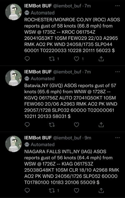
Gust to 67 at ROC. Damage reports rolling in fast and furious from Batavia to ROC area.
-
16 minutes ago, DeltaT13 said:
That’s why I’m happy I’m heading back to the ROC! But it’s the battle zone between those cold pockets and the inland areas that creates the deepest mixing IMO.
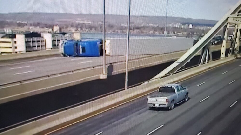
Hamilton Ontario gusting over 60 mph in the last hour. QEW skyway bridge there is closed due to a tractor trailer being blown over blocking all lanes.
-
15 minutes ago, DeltaT13 said:
Winds are ramping up nicely in Buffalo. I’m downtown at a hotel right now about to check out (duffs then home!). Seems quite likely that we’ll see some damaging gusts this afternoon. Forecast has temps slowly falling during the afternoon which should increase surface instability as the ground will still be baking in the sun. That’s when we should see the action.
Full sun and blue sky here. Thinking this might not be as crazy in BUF. Interesting comment on the warmer air over the colder lake keeping the seiche and lake shore flooding aspect likely out of play today. Worst winds will likely run from just NE of BUF through Batavia and into ROC.
Forecast soundings continue to show 80+ knots at 850MB in the warm sector, and 60 knots just off the deck. It`s unlikely we will fully mix to 850MB, but a few thousand feet of diurnal mixing with sunshine appears likely, tapping into the 60 knot flow available just off the surface. This will translate into gusts 55-60 MPH across much of the region, with a corridor of 65+ MPH gusts likely from the Niagara Frontier to Rochester. Unlike many of our wind events, the warm airmass over the cold lakes will result in a more stable boundary layer close to Lake Erie and Ontario, with the strongest wind gusts likely to be across inland areas and not close to the lakeshores.
-
2 hours ago, DeltaT13 said:
Cautiously optimistic for this wind event tomorrow. It’s actually the type of event that brings the most potential. Bring on the sun!
BUF is talking it up more each update… Bust potential is there though if clouds win the sky and mixing doesn’t occur. Looking like prime time for BUF area is noon-4pm.
Aggressive 6 hour 500 mb height fall center on track to move through western New York around mid day Sunday, with a ~995 mb surface low tracking north of the area. Low level wind fields remain very impressive with 850 mb winds near 80 knots and 925 mb winds of 50-60 knots. Biggest question remains as to how much mixing will take place within the warm sector ahead of the cold front, as this is normally a less efficient environment to mix stronger winds to the surface. Sunshine, how much and how long will play a crucial role in how much of the wind aloft can get to the surface. Momentum transfer profiles suggesting that we are likely looking 50-55 knots being able to mix to the surface generally from a corridor from Buffalo to Rochester, maybe as far east as Oswego county and potentially as far south as portions of the Finger Lakes and Southern tier. Of course, less sunshine would limit this amount of wind while more sunshine could bring even higher gusts along with a larger coverage area. Will maintain the high wind watch for the entire area and try to pin down a more confined area for the greatest wind threat in later forecasts, but it should be noted that this event could be a significant if greater mixing depths can be achieved.
There are a few cases of sunshine driven warm sector mixing producing warning criteria wind gusts in the past 10-15 years during the months of March and April, the most notable of which is the March 8, 2017 event. This event does not appear as extreme as 2017, but the magnitude of winds aloft and potential for sunshine driven mixing do draw some parallels.
-
2
-
 1
1
-
-
Ehh quality sucks this way but easier… one last late night Jeb walk?
-
3
-
-
Jeb Walk Baby!!!

-
4
-
-
Not looking that impressive on portion of squall that will impact BUF area. Still some time but doesn’t look nearly as impressive as one last week.

-
Nice looking squall line getting a head of steam north of GTA. Looks like an arrival in BUF around 1 maybe? Some of the meso have this segment breaking apart a bit over the WNY area. We shall see.

-
2
-
-
Rippin out there right now! Yes does look to be drifting a bit more south.
-
6 minutes ago, BuffaloWeather said:
Been so busy following the war that I haven't really looked at anything. I think there is a chance of some lake enhanced stuff ahead of arctic front tomorrow.
Same. Gave it a glance this morning but had nothing at all mentioned for today around BUF. Tomorrow could be interesting noonish - 5pm window if that squall can swing through.
Those clouds rolling in right now look mean!
-
1
-
-
1 minute ago, BuffaloWeather said:
Already couple inches of fluff here. Got 1" in 15 minutes and still heavy snow here.
Our late season surprise event today today maybe? Mesos showed nothing off Erie today. Re read the AFD from this morning (4am) and there was no talk of any activity off Erie. See how long this lasts…
-
2
-
-
30 minutes ago, BuffaloWeather said:
Some 3" per stuff in that band about to move through here
Yeah what the heck… I know I haven’t been staying close past few days but this band surprised me for sure…. Oh well lay down some extra fluff for that squall line to blow around tomorrow…
-
1
-
-
Broken snow squall segments still looking possible for Sunday afternoon.

-
hmm.. a SWS for Strong Winds with the cold front passage...
Special Weather Statement
National Weather Service Buffalo NY
1143 PM EST Tue Feb 22 2022

NYZ001>003-010>012-019-085-230700-
Niagara-Orleans-Monroe-Northern Erie-Genesee-Wyoming-Chautauqua-
Southern Erie-
Including the cities of Niagara Falls, Medina, Rochester,
Buffalo, Batavia, Warsaw, Jamestown, Orchard Park,
and Springville
1143 PM EST Tue Feb 22 2022

...Strong Winds Possible Overnight...

The passage of a cold front shortly after midnight could be
accompanied by southwest winds that could gust as high as 45 mph.
The relatively strong winds...being aided by funnelling down the
long fetch of Lake Erie...could then persist into the wee hours of
Wednesday morning.


Potential large EC storm/Heavy LES March 11-13th
in Upstate New York/Pennsylvania
Posted
Agreed! Wasn’t sure if I was going to catch that area but I did. Got some good videos… 4.5” on the board at 1145. Not to shabby!