

sbnwx85
-
Posts
993 -
Joined
-
Last visited
Content Type
Profiles
Blogs
Forums
American Weather
Media Demo
Store
Gallery
Posts posted by sbnwx85
-
-
Following this one closely in the newsroom. It's also Primary Election Day in Indiana, so we're going to be busy to say the least.
-
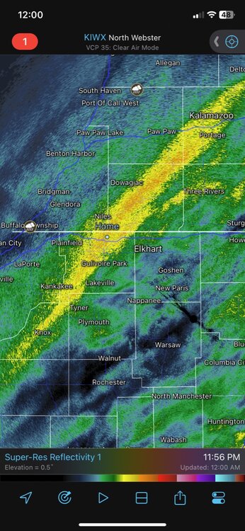
Quality storm right now. Sub-severe but had some gusts 45-50 mph before the heavy rain moved in.
-
Glad we have a thread for this event. My plans with friends fell through so I’m just going to chase this by myself which is kind of exciting since I’m not tied to being stuck in one place. At this point I’ll be targeting Daleville, IN, an interstate town near Muncie. They also have a White Castle!
For anyone on the fence about whether to go see totality or not: do it. It’s an incredible experience. Totality is like something out of a movie. To look up and see a “black hole” where the sun should be is awe inspiring. I had perfect, clear conditions in Missouri in 2017 and it was incredible. I was immediately hooked. I’m considering going overseas in a couple years to see another one in Spain.
-
 5
5
-
-
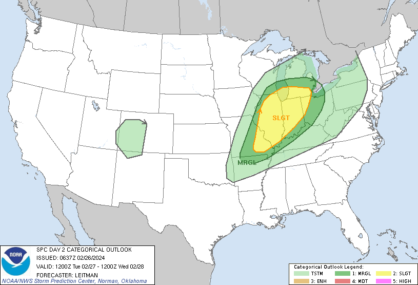
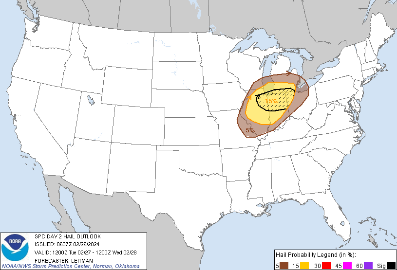
Marginal Risk for much of our forum tomorrow.
Day 2 Convective Outlook
   NWS Storm Prediction Center Norman OK
   1228 PM CDT Mon Mar 25 2024

   Valid 261200Z - 271200Z

   ...THERE IS A SLIGHT RISK OF SEVERE THUNDERSTORMS ACROSS PORTIONS OF
   SOUTHERN ALABAMA AND THE WESTERN FLORIDA PANHANDLE...

   ...SUMMARY...
   An isolated threat for damaging winds and a tornado or two may
   persist Tuesday along/near the central Gulf Coast, with a separate
   area of isolated strong to severe thunderstorms potentially
   developing by Tuesday afternoon across parts of the Midwest and
   southern Great Lakes.

   ...Synopsis...
   Extensive upper troughing is expected to cover the majority of the
   CONUS early Tuesday morning. Moderate to strong mid-level flow will
   extend throughout this troughing Tuesday morning, arcing
   cyclonically from the West Coast across central Mexico and the TX
   Gulf Coast, and then up the MS Valley through the Upper Great Lakes.
   Several shortwave troughs will be embedded within this large
   troughing, with the most prominent shortwave beginning the period
   over the Mid MS Valley. Expectation is for this shortwave to move
   quickly northeastward into eastern Ontario by the afternoon,
   accompanied by very strong mid-level flow (i.e. 100+ kt at 500 mb).
   Deep surface low associated with this wave is also expected to move
   northeastward from its initial position over northwest WI into
   northwest Ontario. As it does, an attendant cold front will sweep
   quickly eastward/northeastward across the Mid MS Valley, the Upper
   Great Lakes, and the OH Valley.

   Farther south, thunderstorms will likely be ongoing early Tuesday
   morning along an outflow-reinforced cold front stretching from
   middle TN southwestward off the AL/MS coast. Steady eastward
   progression of this front is expected throughout the day, before it
   stalls over GA and the eastern FL Panhandle Tuesday evening.

   ...Southern AL into Southeast GA and the FL Panhandle...
   Ongoing convective line is expected to extend from central AL into
   coastal AL and the far western FL Panhandle early Tuesday morning.
   Moderate low-level moisture and buoyancy will be over southwest
   AL/coastal AL and the far western FL Panhandle early Tuesday, with
   some potential for damaging gusts and maybe even a brief tornado or
   two as the line moves through. An isolated severe threat may persist
   into Tuesday afternoon and continue through Tuesday night across
   southeastern AL, southwestern GA, and the FL Panhandle vicinity as
   mid to upper 60s surface dewpoints attempt to advance inland across
   these areas. However, poor lapse rates aloft and limited daytime
   heating from cloud cover should temper buoyancy, leading to a
   gradually diminishing storm intensity.

   ...OH Valley/Southern Lower MI...
   Clearing is anticipated in the wake of the warm conveyor and ahead
   of the primary cold front across the OH Valley and southern Lower
   MI, beginning during the late morning over IL. This clearing is
   expected to allow temperatures to climb into the 60s. Low-level
   moisture will be limited (i.e. in the low 50s), but the combination
   of modest low-level moisture with temperatures in the 60s and cold
   mid-level temperatures (i.e. around -20 deg C at 500 mb) is expected
   to result in air mass destabilization and modest buoyancy. Shallow
   thunderstorms are expected to develop along the cold front as it
   interacts with this destabilized air mass, likely beginning during
   the late morning across IL before then moving eastward/northeastward
   throughout the day. Buoyancy will be modest, but robust low to
   mid-level fields will be present and the deep-layer vertical shear
   vector will oriented mostly perpendicular to the front. These
   factors suggest fast-moving storms capable of damaging gusts,
   particularly since the gradient surface wind will already be
   enhanced. A tornado or two is also possible, although the limited
   storm depth could act as a limiting factor for greater storm
   organization.

   ..Mosier.. 03/25/2024
-
Event of the year for some.
-
We've got about an inch of snow. Not usually note-worthy in February but it is a shock to the system after yesterday's Spring-like weather.
-
Well outside of our sub but it's worth a mention. Sierra Nevada Blizzard Warning for three days. Lake Tahoe communities expecting 2 to 4 feet with 60 mph winds. My dream is to spend at least one winter out there.
Extended Forecast for
South Lake Tahoe CA
Thursday NightSnow. The snow could be heavy at times. Widespread blowing snow, mainly between midnight and 5am. Low around 29. Windy, with a southwest wind 25 to 30 mph, with gusts as high as 50 mph. Chance of precipitation is 90%. New snow accumulation of 5 to 9 inches possible.FridaySnow. The snow could be heavy at times. Widespread blowing snow, mainly after 11am. High near 33. Breezy, with a southwest wind around 25 mph, with gusts as high as 45 mph. Chance of precipitation is 90%. New snow accumulation of 7 to 11 inches possible.Friday NightSnow. The snow could be heavy at times. Widespread blowing snow. Low around 25. Windy, with a southwest wind 25 to 30 mph, with gusts as high as 55 mph. Chance of precipitation is 100%. New snow accumulation of 14 to 20 inches possible.SaturdaySnow. The snow could be heavy at times. Widespread blowing snow, mainly before 11am. High near 28. Breezy. Chance of precipitation is 100%. New snow accumulation of 10 to 16 inches possible.Saturday NightSnow before 11pm, then snow showers likely after 11pm. The snow could be heavy at times. Patchy blowing snow before 11pm. Mostly cloudy, with a low around 17. Breezy. -
Worried about a cap in February.

-
3
-
 3
3
-
-
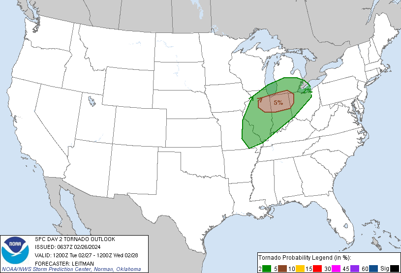
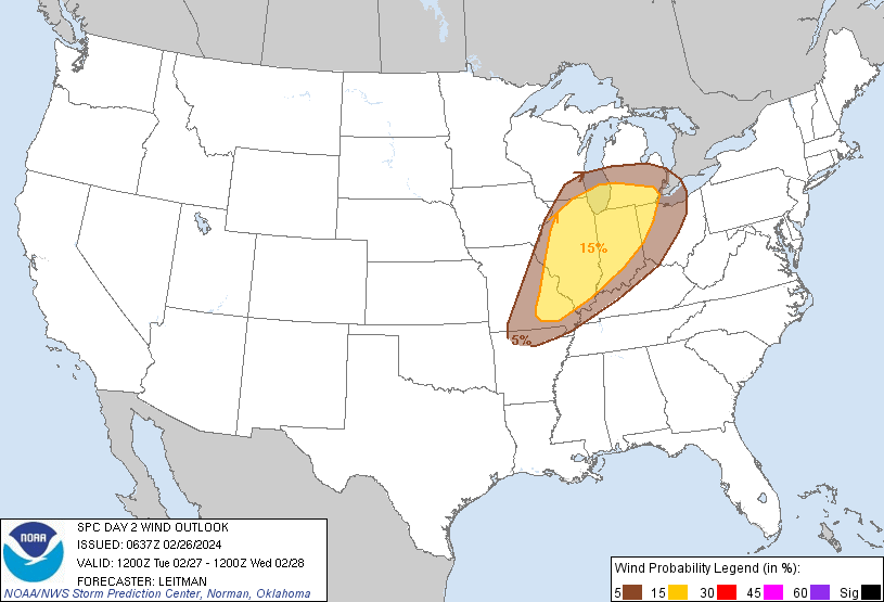
NAM initiates convention around 23z but much further west toward Peoria. NAM doesn’t seem to be “off the charts” like the HRRR but still a good tornado potential across the 5% area SPC has outlined. I’ll let the experts dive deeper into the setup.
-
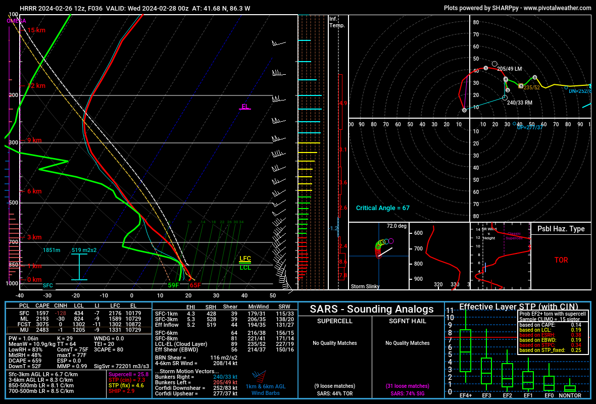
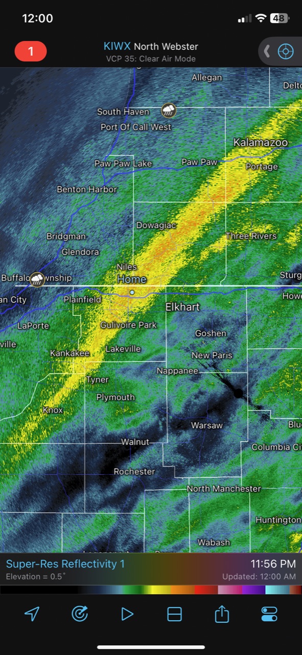
The 12z HRRR providing some eye candy around Michiana. Convection doesn’t really pop until 01z allowing for discrete storms to move through before going linear. Waiting to see what the NAM does.

-
An El Niño Febnado?
SUMMARY...
   Scattered strong to severe thunderstorms, associated with large hail
   (some near 2 inch diameter), damaging gusts, and a few tornadoes
   will be possible from late Tuesday afternoon, into the evening and
   overnight from parts of the mid Mississippi Valley, and southwestern
   Great Lakes.

   ...Mid-MS Valley/Southwest Great Lakes Vicinity...

   An upper trough over the northern Rockies/Intermountain West will
   shift east on Tuesday, becoming oriented from the Upper MS Valley
   and Mid-MO Valley by Wednesday morning. Fast deep-layer
   southwesterly flow ahead of this feature will overspread the Ozark
   Plateau into the Great Lakes. At the surface, a low will deepen as
   it shifts east from MN toward southern Ontario. A cold front
   attendant to the low will quickly shift east/southeast across the
   Plains and the Mid/Upper MS Valley during the afternoon and into the
   overnight period. Initial thunderstorm activity may develop in warm
   advection regime near the quasi-warm front/moisture gradient from
   northern IL into IN/NW OH/southern MI around 21-00z. Additional
   activity will then develop along the cold front as it develops east
   and the main upper wave ejects into the region around 00-03z.

   Warm advection and southerly low-level flow ahead of the front will
   allow for modest airmass modification into the Midwest. However,
   forecast dewpoints are only expected to reach into the 50s to near
   60 F. Nevertheless, a plume of steep midlevel lapse rates will
   overspread the IL/IN/MI/OH vicinity from afternoon into the evening.
   This will support modest destabilization with MLCAPE generally
   forecast to be less than 1000 J/kg, though a narrow corridor of up
   to 1500 J/kg MLCAPE may be possible for a brief period around 00z.
   Forecast soundings across the region indicate most of available
   instability will be located above the 850-700 mb layer.

   Initial thunderstorm activity may be slightly elevated as some
   forecast soundings indicate a warm nose between 850-700 mb during
   late afternoon/early evening. Nevertheless, effective shear greater
   than 50 kt, and enlarged low-level hodographs becoming elongated
   above 3 km indicate initial supercells will be possible near the
   quasi-warm front/moisture gradient from northeast IL into northern
   IN and vicinity. With most instability focused above the 850-700 mb
   layer, and in conjunction with poor boundary-layer dewpoints, the
   tornado risk may be somewhat lower than typically expected given
   shear profiles in the 0-2 km layer. Nevertheless a couple tornadoes
   are possible, especially if greater moisture than forecast can make
   it this far north. Large hail, with a few instances near 2 inch
   diameter, will be possible with any semi-discrete supercells, along
   with damaging gusts.

   Once linear forcing along the front increases in the 00-03z period,
   a line of storms is forecast to develop east from the Mid-MS Valley
   toward the Lower OH Valley during the nighttime hours. Damaging
   gusts will be the main concern with this activity.
-
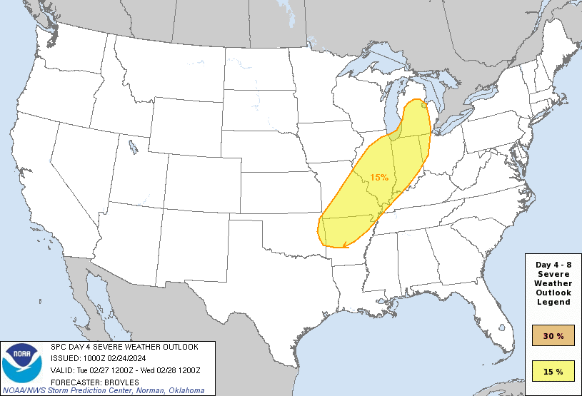
Large Day 4 slight risk.
...DISCUSSION...
   ...Tuesday/Day 4 and Wednesday/Day 5...
   An upper-level trough is forecast to move across the central U.S. on
   Tuesday, as an associated mid-level jet moves from the southern
   Plains into the mid Mississippi Valley. Moisture advection, ahead of
   a cold front, will likely take place from the Ark-La-Tex
   northeastward into the southern Great Lakes. In spite of abundant
   cloud cover, some destabilization is forecast across the moist
   sector ahead of the front. The ECMWF has MLCAPE generally peaking in
   the 500 to 1000 J/kg range along parts of the moist axis by
   afternoon. As thunderstorms develop ahead of the front during the
   late afternoon and early evening, a severe threat is expected from
   the Ozarks northward into the southern Great Lakes. Wind-damage, and
   perhaps a few tornadoes would be possible with supercells and/or the
   stronger bowing line segments.
-
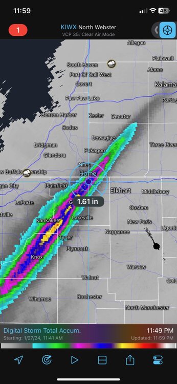
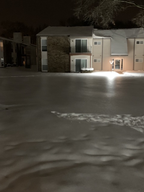
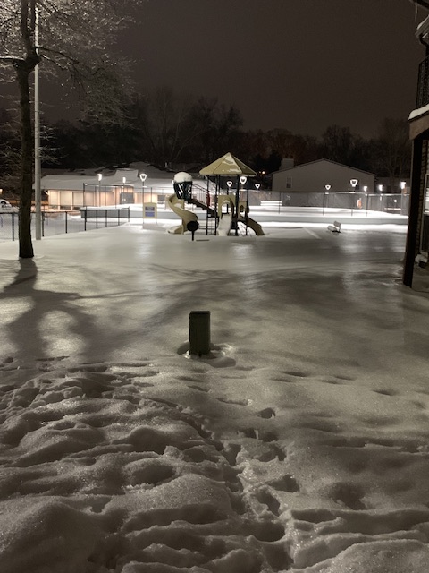
Measured 2.2” in my backyard. Impressive event for such a Spring-like stretch we’re in.
-
Should be really picturesque in the morning.
-
1
-
-
Not to give the climate change enthusiasts any more ammo but I just set a personal record for earliest date that a bug flew into my mouth.
-
1
-
9
-
-
Up to 63 at SBN. Record is 66.
-
I'd love to see the data on late-February heavy lake effect events because I can't imagine there are many. Anyway, here's me grasping at straws for heavy snow in more than a week.

-
Unconfirmed reports of about 20 homes damaged.
6 minutes ago, CheeselandSkies said:Seen a couple videos of the Evansville-Edgerton tornado. Actually looked smaller than I was expecting based on the size/depth of the CC drop. Must have been small but fairly strong, and hit a lot of stuff.

-
February rockin’ with 40’s and sun.
")
-
There’s been a band of moderate to heavy rain parked overhead for the last 3 or 4 hours. Too bad it’s not 10 degrees colder.
-
1
-
-
It’s raining again. My snowpack is gone. Ready for spring.
-
2
-
-
 4 hours ago, TheClimateChanger said:
Winter to date temperatures below for some selected sites in the midwestern United States. Looks like 2023-24 will be moving up on these lists through at least the beginning of February.
Detroit (9th warmest)
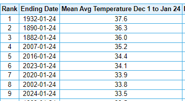
Cleveland (10th warmest)
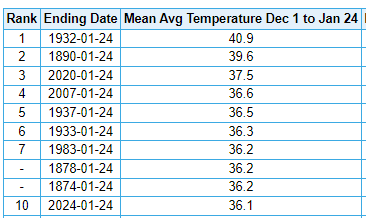
Toledo (10th warmest)
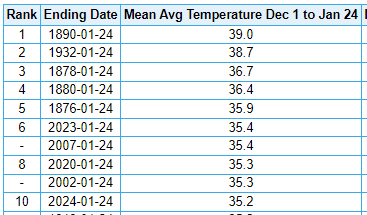
Fort Wayne (9th warmest)
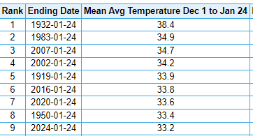
South Bend (8th warmest)
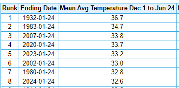
Lansing (6th warmest)
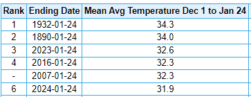
Mansfield, Ohio (10th warmest)
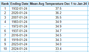
Marquette (NWS) (warmest)
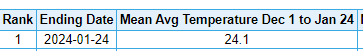
Green Bay (2nd warmest)
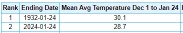
Minneapolis/St. Paul (2nd warmest)
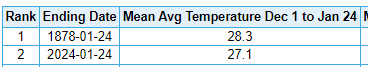
International Falls (warmest)

-
6
-
-
Gonna be a foggy couple nights, at least.
-
Looks like about a tenth of an inch of ice on ground level surfaces. Looks neat on the snow.
-
8
-

May 2024 General Discussion
in Lakes/Ohio Valley
Posted
We have a G5 storm!