

MazooWeather
-
Posts
3,866 -
Joined
-
Last visited
Content Type
Profiles
Blogs
Forums
American Weather
Media Demo
Store
Gallery
Everything posted by MazooWeather
-
Wonderful pics, very very lucky it didn't hit anywhere big at peak strength
-
-
-
That tornadic storm that moved into me I think only died because of crossing the front which is parked over the county, I was sweating bullets
-
-
PDS TOR for me
-
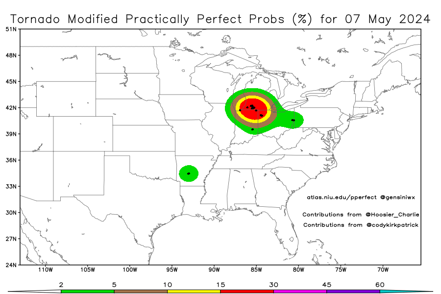
How has IWX not put a TORR on this?
-
Making a right turn too
-
That hook is headed right into the Kalamazoo area
-
Berrien County storm looks spicy
-

Severe Weather 5-6 through 5-9-24
MazooWeather replied to cheese007's topic in Central/Western States
TOR for OKC -
Severe Weather 5-6 through 5-9-24
MazooWeather replied to cheese007's topic in Central/Western States
The OKC supercell turned into a line instead -
Severe Weather 5-6 through 5-9-24
MazooWeather replied to cheese007's topic in Central/Western States
There's also some new cells going up southwest of the line now -
If we somehow outperform the OK event that would be something
-
Severe Weather 5-6 through 5-9-24
MazooWeather replied to cheese007's topic in Central/Western States
Okeene cell with a strong circulation is about to go -
Severe Weather 5-6 through 5-9-24
MazooWeather replied to cheese007's topic in Central/Western States
Off to the races now with extra initiation happening -
Severe Weather 5-6 through 5-9-24
MazooWeather replied to cheese007's topic in Central/Western States
From the new MD In addition, VWP data from KOUN and KVNX depict a notable increase in low-level flow over the last hour, with some modest backing of surface winds noted in recent Oklahoma Mesonet data. 0-1 km SRH of around 200 m2/s2 was noted in the 21Z OUN sounding, with values expected to increase above 300 m2/s2 into this evening. The combination of strengthening low-level shear and strong to extreme instability will support a rapid increase in potential for strong and possibly long-tracked tornadoes as storms spread east-northeastward this evening. -
Severe Weather 5-6 through 5-9-24
MazooWeather replied to cheese007's topic in Central/Western States
Southern extent of the supercells looks a little less than expected rn maybe -
Northern Indiana upgraded to enhanced for 10 sig tornado
-
Looks to be a seasonal start to the month with frequent chances for rain and storms but with lotsa nice days too.
-
That once cell in NE Indiana really tried to drop a tornado but got choked out by the rain around it
-
2024 Short/Medium Range Severe Weather Discussion
MazooWeather replied to Chicago Storm's topic in Lakes/Ohio Valley
That enhanced was such a screw up, there's been more Tor Warnings in the marginal areas down south -
2024 Short/Medium Range Severe Weather Discussion
MazooWeather replied to Chicago Storm's topic in Lakes/Ohio Valley
Kinda like the last two days where they went too high and busted -
4/1-4/2 severe threat (southern portion of subforum)
MazooWeather replied to largetornado's topic in Lakes/Ohio Valley
Skies look to be clearing from Kentucky into Central Ohio -
Areas affected by Tornado Warnings between April 3rd and 4th 1974 Share any memories and stories you all have here Mine is that I've heard from many locals, is that the EF-2 Tornado that hit Hillsdale sent the statue outside the Big Boy restaurant flying through the air and it landed over a half mile away on a house that wasn't even hit by the tornado.


