HO1088
-
Posts
106 -
Joined
-
Last visited
Content Type
Profiles
Blogs
Forums
American Weather
Media Demo
Store
Gallery
Everything posted by HO1088
-
It would probably be too warm to snow tonight in the Cleveland snowbelt suburbs, but the Lake to 850 temp difference will be 24 degrees C after midnight. Thunder?
-
Graupel here in Chagrin Falls. The first official "snow" of the season.
-
The fog has been fun today. What a difference 5 miles makes. KLNN 072035Z AUTO 04007KT 7SM OVC004 19/17 A3020 RMK AO1 T01910173 KCAK 072051Z 21008KT 10SM SCT040 28/19 A3019 RMK AO2 SLP213 T02830194 55007 $
-
Wow!

-
Not many leaves down at all in my area as of yet. Things seem unusually green and lush. 6.87" of rain for September. Yet another overly wet month.
-
That's quite a bit. I was closer to 2" but already above 4" for the month.
-
NWS issued a Flash Flood Watch for NE Ohio on Sunday. The ECMWF and GFS forecast about 1" of rain with the heaviest to the east in Western PA. The NAM shows about 5" for NE Ohio. It's rained for 7 days in a row here in Chagrin Falls.
-
1.13" in Chagrin Falls today. One of the rare instances where persistence would have been a better forecast than the 20% PoP the NWS CLE had today (again). It would be an improvement if the NWS could convey/predict/acknowledge the existence of the minor flash flooding that occurs during these lake enhanced summer events. They happen several times per year, yet they rarely if ever are predicted or even acknowledged. The flood advisory wasn't issued until about 3 p.m. and the event was over by that point. I saw my first cumulus cloud today at 11:45 a.m. and the thunderstorm started around 1:30 p.m. It doesn't take long to build in this humidity once the convective temperature is reached in the late morning. At 5 p.m. my dewpoint was 79 F. At 5:18 pm it is now 80 F dewpoint. Never thought I'd see the day.
-
0.49" last night in Chagrin Falls, but earlier in the day we missed two big storms...one over Burton and one just south near Solon. All on a day that was forecast "mostly sunny". The lake influence is impressive. When the dewpoint gets high the pattern resembles that of South Florida. It seems it doesn't matter how high the pressure is, with lots of humidity and a warm lake the cumulus will develop.
-
With the high dewpoints the last couple days of (unpredicted) lake breeze fronts and associated showers and thunderstorms has been fun to watch.
-
KCGF 221619Z 31015KT 10SM BKN020 BKN040 21/16 A2995+FC(funnel cloud-tornado) RMK +FC(funnel cloud-tornado) E1619 MOVD EKCGF 221556Z 31015KT 10SM BKN017 BKN030 21/16 A2996+FC(funnel cloud-tornado) RMK +FC(funnel cloud-tornado) B1556 6NE MOV NE
-
About 7.5" of rain in Chagrin Falls for July. Temperatures slightly above normal, but mostly due to the humid air with significantly higher than normal minimum temps.
-
Looks like Cleveland recorded their warmest May on record. https://www.cleveland.com/expo/erry-2018/06/5ceb541a8e4149/after_record_heat_in_may_cleve.html
-
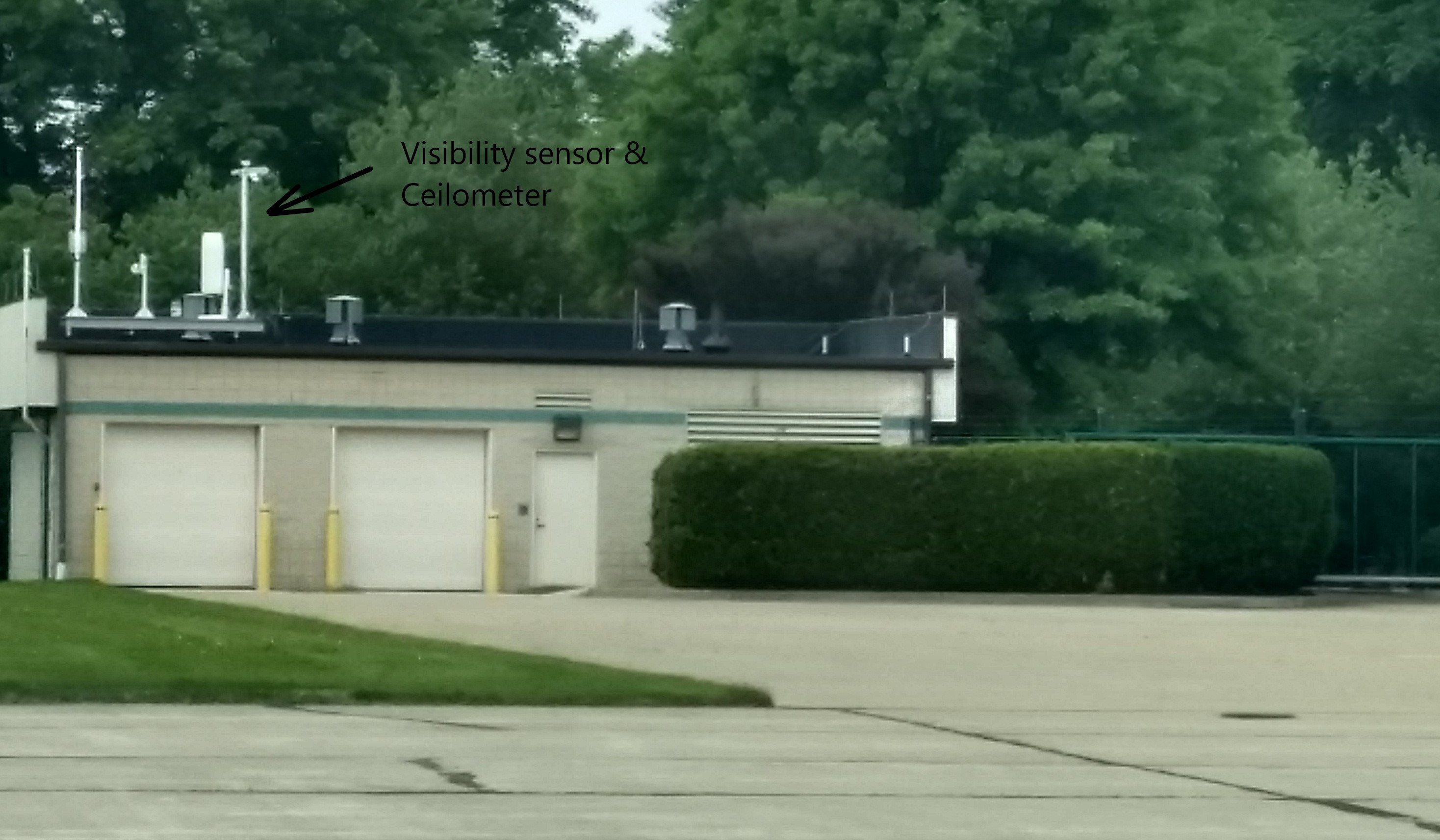
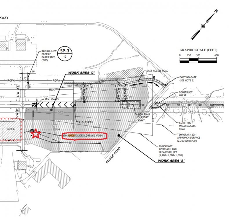
I was at Cuyahoga County Airport today in Richmond Heights (KCGF), and I was told that an AWOS will be installed by the winter, on the east side of the airport near Bishop Rd. 24 hr observations will be available for the first time in the airport's history. It's one of the few airports in the country where manual observations are still taken only when the control tower is open. I also noticed a ceilometer and visibility sensor on top of a roof at the airport (odd placement for such sensors). I don't think they are associated with the official weather that comes from CGF, not sure who owns them but found it unusual as I assume they are private?

-
Storm dynamics usually surprise me, but it seems like in this case a boundary layer temperature difference of 1 C from forecast is enough for a forecast bust. Where is the cold air?
-
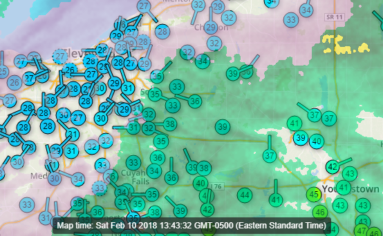
Definitely an unusual temperature setup on Saturday. KCLE reported freezing rain most of the day while it got up to around 40° further east, around Middlefield. Here in Chagrin Falls I was socked in with clouds and fog most of the day and just above freezing, but it is now getting slowly colder and the wind has shifted to the north. Sitting under this baroclinic zone has gotten me in a foul mood. Today is the 8th straight day with precipitation. It doesn't look like the pattern will change much until the end of next week. February in Northeast Ohio.
-
http://www.cleveland.com/weather/blog/index.ssf/2018/02/how_does_clevelands_winter_so.html#incart_river_mobile_home
-
8” here in Chagrin Falls this morning. Water equivalent 0.42”.
-
https://pjmedia.com/lifestyle/frozen-lake-erie-forces-cancellation-annual-polar-bear-plunge-cleveland/amp/
-
Even the once robust streams off Huron are dissipating due to dry air. This is turning into a busted forecast quickly. It was partly sunny this afternoon in Chagrin Falls. That never happens in December with an onshore wind -- some mighty dry air.
-
Looks like a lot of cold air advection with some decent vorticity advection Tuesday evening. Anyone think thundersnow is a possibility? Western Lake Erie water temperature seems to be about 40° on average as of December 10th.
-
It felt more like October this morning than late August. My low was 49°F. Has there been smoke aloft lately across Northeast Ohio? The sky has definitely had a milky appearance to it, and whatever it is looks like it is in the upper troposphere.
-
There sure is a lot of Lake Effect developing upstream on the other side of the arctic front. For what it's worth, CLE does show the front and squalls in the aviation TAF from 21-24Z with 1/2 mi. visibility.
-
Great image. Thanks for posting it.
-
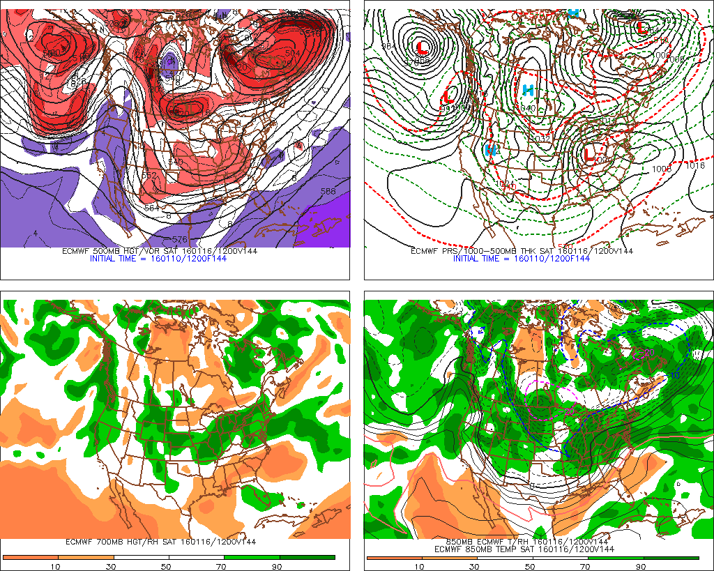
Big snow for Saturday? Latest CLE AFD likes the ECMWF.