HO1088
-
Posts
106 -
Joined
-
Last visited
Content Type
Profiles
Blogs
Forums
American Weather
Media Demo
Store
Gallery
Everything posted by HO1088
-
It's so rare we get a decent synoptic snow storm in NE Ohio. I remain skeptical.
-
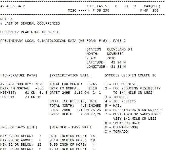
Just finished 28 consecutive days of above normal temperatures at CLE. So far January has been 11 degrees above normal.
-
CLE and NE Ohio have a good shot at below normal precipitation for the month of December. The last time that happened was 11 months ago, January 2018. There has been above normal precipitation recorded every month since then.
-
Yesterday was interesting with the stratus clouds from the lake breeze. The west side had a lot more mist and overcast than the east side did. It's been a dry period over the last week. A welcome relief from November's wetness. Scott Sabol on FOX said a mild end to December with much colder weather for January. How many winters have no significant lake effect? Does it ever happen?
-
About 2" of snow remain on the ground this morning, although the boring yet persistent stratus clouds continue. The next 10-days look about as boring as winter can get. Seems like really mundane weather this season, unless you like gray stratus clouds. Heck, the deep South is forecast to have more interesting weather.
-
Scott Sabol on FOX8 this morning revealed November 2018 was the 3rd cloudiest November in Cleveland's recorded history at 84%.
-
Saturday-Wednesday the European shows dry weather. That's very unprecedented here in Northeast Ohio in December.
-
5.20" of liquid precip for me in November.
-
Jeesh, I wonder if NE OH will get any decent lake effect this winter. It was frustrating last night seeing all the healthy plumes on the leeward side of Lake Michigan while we had flurries and at best disorganized lines of -SHSN. I can't wait for the gloomy, cold and wet November to be over. I think it really messed up our chances this winter for lake effect. CLE is over 90% cloud cover this month in their climate CF6 report. I wouldn't be surprised if the lake gets a decent amount of ice on it come December if this pattern doesn't change. November will finish about -6 degrees below normal with over 5" of precip when it's all said and done.
-
-
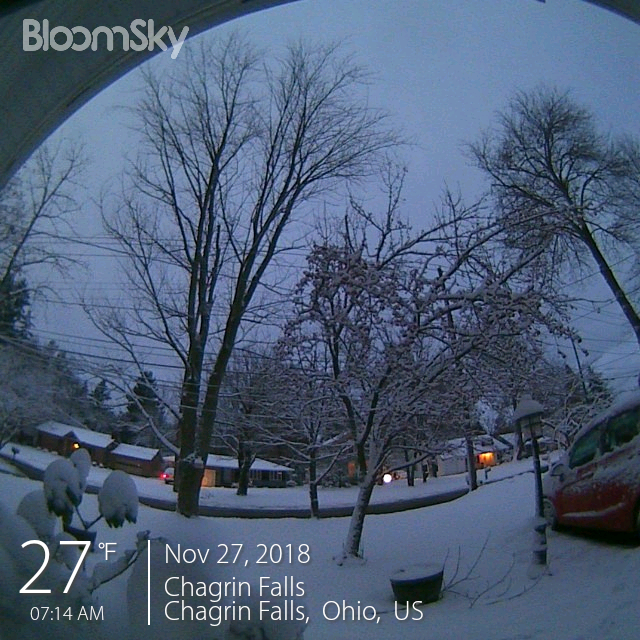
About 4.5" of snow here in Chagrin this morning. Everything is white and the snow is wet and heavy, it's good to see that here every once in a while. No lake effect to speak of. Did the cold and dark November significantly limit lake effect this season?
-
So far the west side is getting the good stuff.
-
Just changed over to snow here in Chagrin at 16:00. Ground is really soggy.
-
Cuyahoga County Airport now has an AWOS. 216-289-4113 It is scheduled to start transmitting officially in December.
-
The ECMWF models the trough over the South shore of Lake Erie Tuesday night. Temps are cold enough, the wind over the lake is the right direction and there is a lot of convergence.
-
With the low that gives us rain on Monday forecast to stall over Maine and the Canadian Maritmes for a few days (unlike the previous pattern of lows moving more progressively east), it looks like we may be able to keep more boundary layer humidity and thus maybe have a good shot of lake effect snow (I hope)?
-
-6 F on average at CLE this month with almost no sun to speak of, yet not one major lake effect event. Bizarre pattern.
-
Freezing rain and poorly formed sleet in Chagrin since it started. 30/24 at 8 am.
-
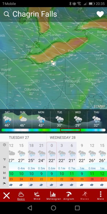
The 12Z ECMWF on Windy.com shows 6" for the eastern suburbs of Cleveland! Very tricky forecast.
-
Perhaps if the low was closer to us the boundary layer wouldn't have been so dry?
-
I had about 0.5" of snow for the storm. Elevation made a big difference. Strong winds overnight but they have subsided a bit ever since sunrise. Impressive thundersnow with the squalls around Dunkirk, NY (KDKK) this morning.
-
https://www.cleveland.com/datacentral/2018/10/2018-has-been-one-of-the-wettest-years-on-record-in-cleveland-and-more-rain-is-in-the-forecast.html
-
About 1.75" here in Chagrin Saturday morning to Monday morning. It's still raining this afternoon but as the wind backs hopefully the band will stop. My lawn feels more like a wet April soggy mess than late fall.
-
It must be dry or perhaps there is a big inversion, because the stratocumulus layer overnight and this morning isn't thick enough to produce meaningful lake effect. Odd considering the cold air, but perhaps the cold air is very shallow? Power outages on the west side with lots of small hail last night and some impressive wind. https://www.cleveland.com/metro/index.ssf/2018/10/thousands_of_firstenergy_custo.html
-
There was a thunderstorm in Chagrin at 2:30 pm and as of 4:30 pm KCLE reported a gust of 52 mph.