
Extreme NEGA
-
Posts
219 -
Joined
-
Last visited
Content Type
Profiles
Blogs
Forums
American Weather
Media Demo
Store
Gallery
Posts posted by Extreme NEGA
-
-
14 minutes ago, Buckfever2 said:
I don't know much about this stuff so forgive me if I sound a little naive but... Does it look like the cold will already be in place when the moisture arrive or, will it be a situation where it changes from rain to snow?
It's too early to get into the specifics of it really but going off the latest Euro model I would not be surprised if it started as some rain down your way. It's still a week away so many changes going forward. Models are not in agreement as of right now but this afternoon's Euro run was a good start to what is hopefully a trend.
-
2 minutes ago, SnowDawg said:
I feel like in this pattern that is quite possibly the best look we could hope for board wide. Weak over running, followed by late coastal development, means literally no one has to deal with any warm air advection. If it bombed out earlier it'd screw the eastern zones, and if it lost the over running it'd screw us to the west. Can't imagine the mood on this board if such a region wide event were to go down.
Atlanta shutsdown again lol
-
 1
1
-
-
2 minutes ago, Lookout said:
Soundings are fine from what I see. Its surface temps are obviously too warm given the snowfall. Keep in mind the euro busted pretty bad with the weekend snow...ended up being 5 to 8 degrees too warm at the surface.
Yep the suface temps is what I was referring to but that is true about last weekends system. Nice to finally have something on on the euro too.
-
Soundings don't look good though
-
 1
1
-
-
Euro does not look like the GFS

-
Can I give my rain to somebody else?!
-
 1
1
-
-
This thing might have legs since the Euro and CMC is showing it. GFS lol well it's what I call the flip flop model lol. Maybe will see a better run from it today or we lose this all together ha.
-
2
-
-
29 minutes ago, SnowDawg said:
That's so wild. Got to 49 here today with full on sunshine.
It's still cloudy here.
-
2 hours ago, burrel2 said:
Low clouds still haven't lifted here. Satellite presentation is odd to the say the least.
Yea it's strange. Drove to Helen, GA the sun was out and 50 degrees. Came back to Toccoa cloudy and 37.
-
16 minutes ago, ATLMet84 said:
It was also amazing the temp difference in North GA today. While Gainesville only hit 33, my station only hit 33.9, Atlanta hit 45 and Peachtree City hit 49! Next issue is freezing fog. Can anyone that had accumulating snow see anything outside? The fog is as dense as I've ever seen it here. Temp is 31.2 and probably will end up in the upper 20s in the morning. Crazy weather (and I'm loving it!)
Should have a nice view there in the morning with everthing glazed over. It's not foggy here yet.
-
I guess we don't get a Special weather Statement

-
1
-
-
It's great to be able to get the sled out and boat the same week.

-
1
-
2
-
-
Again really?
-
Back to some light snow
-
4.5 total here in Toccoa.
-
1
-
-
4 inches here but coming to the end soon
-
GSP trying to play catch up:
.NEAR TERM /THROUGH TONIGHT/...
As of 1100 AM: Light to moderate snow, with some areas of +SN
continues to overspread the Upper Savannah River Valley and the NC
mtns late this morning. The latest high res/ short term models
indicate partial thickness values are more than favorable for snow
across all but perhaps the extreme southeast part of the forecast
area, so p-type will hinge largely on surface temps. Mid clouds
overspreading the western part of the area just after sunrise
resulted in surface temps not warming as fast as previously
anticipated. While some warming from the south is expected to occur
into the afternoon, which could force a changeover to rain south of
I-85, it`s looking increasingly like locations across the western
half of the area, and along/north of I-85 will see mostly snow. The
Winter Weather Advisory has been expanded to include another row of
zones to the south of the old advisory. Even outside of the advisory
area, accumulating sub-advisory snowfall (< 1 inch
Piedmont/foothills), < 2 inches mountains are likely. The only
exception may be the I-77 corridor, where temps have warmed to
around 40, and guidance strongly agrees that liq equivalent precip
will only be around 0.05". Nevertheless, with surface wet bulb temps
still just below freezing, especially north of I-85, some dustings
will be possible in those areas.

The wave responsible for this mess will move rapidly east this
evening, with lingering precipitation paring back to the typical
west to northwest flow moisture areas before ending overnight. This
airmass will support max temps today some 15 to 20 degrees below
climo, with mins 1 to 2 categories below climo tonight.
-
Heard Rabun Co has 4 inches and road are impassable.
-
2.5 here
-
1
-
-
31 degrees and still snowing. Got 2 inches. a bust by GSP
-
1
-
-
15 minutes ago, NEGa said:
Yes they are lol. It has started sticking on the roads around here now
Same here
-
Ground is white here
-
2
-
-
Coming down pretty good now
-
Snow just starting here
-
2
-
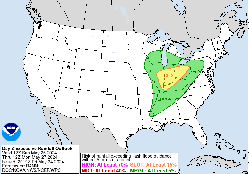
Mid to Long Term Discussion 2020
in Southeastern States
Posted
I can't believe it. WoW GSP