HWY316wx
-
Posts
861 -
Joined
-
Last visited
Content Type
Profiles
Blogs
Forums
American Weather
Media Demo
Store
Gallery
Everything posted by HWY316wx
-
The “I bring the mojo” Jan 30-Feb 1 potential winter storm
HWY316wx replied to lilj4425's topic in Southeastern States
Then it may be legit! I am hoping it fills back in like the hi-res's are showing. I still have it flying here. But not at the rate it was. -
The “I bring the mojo” Jan 30-Feb 1 potential winter storm
HWY316wx replied to lilj4425's topic in Southeastern States
Yes sir! Good to see you around posting. I am hoping for more, but I am skeptical. Back west of us, people are PISSED. The cutoff line is sharp. Roads are bad in Gainesville. I saw where a guy was saying he got 5.5" in Habersham County but not sure if thats a drift or legit. -
The “I bring the mojo” Jan 30-Feb 1 potential winter storm
HWY316wx replied to lilj4425's topic in Southeastern States
ATL got dry slotted hard. Some people posted blue sky and not even a flurry in the sky. Most people from Dawsonville to Cumming to Winder reporting 2-3". It is hard to tell because of the wind.
-
The “I bring the mojo” Jan 30-Feb 1 potential winter storm
HWY316wx replied to lilj4425's topic in Southeastern States
Sitting at 2" and the snow globe is still going. Simulated radar shows more coming, but the real radar doesn't show it so I am skeptical. Good luck to you guys up in the Carolinas to jackpot! -
January 30th- Feb 1st ULL and coastal storm obs
HWY316wx replied to JoshM's topic in Southeastern States
Well, I hope this just fills in more and more.
-
The “I bring the mojo” Jan 30-Feb 1 potential winter storm
HWY316wx replied to lilj4425's topic in Southeastern States
Especially this kind of snow. -
The “I bring the mojo” Jan 30-Feb 1 potential winter storm
HWY316wx replied to lilj4425's topic in Southeastern States
2 WSW's inside of 7 days. Glory days. Good to see you around these parts. Always enjoy your postings when we get into these things. -
The “I bring the mojo” Jan 30-Feb 1 potential winter storm
HWY316wx replied to lilj4425's topic in Southeastern States
A lot of members would be happy with this, including myself. -
The “I bring the mojo” Jan 30-Feb 1 potential winter storm
HWY316wx replied to lilj4425's topic in Southeastern States
The question is, which one do you buy? The EURO has paid me way more times than the NAM ever thought about. Just say'n. -
The “I bring the mojo” Jan 30-Feb 1 potential winter storm
HWY316wx replied to lilj4425's topic in Southeastern States
FFC out of Atlanta afternoon video is really good stuff! -
The “I bring the mojo” Jan 30-Feb 1 potential winter storm
HWY316wx replied to lilj4425's topic in Southeastern States
Gwinnett could see 2-4" so I would consider it an ATL storm. That cutoff line may cut the city in half, just depends on how far it comes West and by all accounts not 1 model knows. They change every 6 hours. -
The “I bring the mojo” Jan 30-Feb 1 potential winter storm
HWY316wx replied to lilj4425's topic in Southeastern States
Georgia folks. Time to wake up. The westward trend is our friend. I am going to hug the 6Z EURO into Sunday.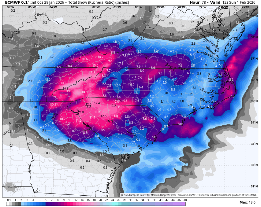
-
The “I bring the mojo” Jan 30-Feb 1 potential winter storm
HWY316wx replied to lilj4425's topic in Southeastern States
If everyone would quit hitting F5 and just let me hit it, we could get on down the road. -
The “I bring the mojo” Jan 30-Feb 1 potential winter storm
HWY316wx replied to lilj4425's topic in Southeastern States
Facts. When I see SnowGoose, Wow, Eyewall and StormTracker all on one page... you know it's good times. -
The “I bring the mojo” Jan 30-Feb 1 potential winter storm
HWY316wx replied to lilj4425's topic in Southeastern States
Weenie run inbound. Even GA guys might get brought into the chat on this one. NC big score though. -
The “I bring the mojo” Jan 30-Feb 1 potential winter storm
HWY316wx replied to lilj4425's topic in Southeastern States
This clown map looks like a guitar. I think TWC should name this one Prince. I will see myself out. -
The “I bring the mojo” Jan 30-Feb 1 potential winter storm
HWY316wx replied to lilj4425's topic in Southeastern States
For the love... you guys are gonna suck me back into this... -
The “I bring the mojo” Jan 30-Feb 1 potential winter storm
HWY316wx replied to lilj4425's topic in Southeastern States
CMC says they disagree, but I get your point. -
The “I bring the mojo” Jan 30-Feb 1 potential winter storm
HWY316wx replied to lilj4425's topic in Southeastern States
Need this to come way West to involve more of the GA guys which would be a major hit for the NC guys. I am rooting for the W-NW trend. Carry on. -
Southern Crippler - Get well soon Jimbo Storm Obs
HWY316wx replied to BooneWX's topic in Southeastern States
Much like you boys up in the Carolinas, mainly sleet here overnight. Some ZR but more sleet than anything, hardly any ice on limbs or leaves. Still have power. I am incredibly curious how the CAD holds here in NE GA as the LPS pulls north and tries to pull the warm air north. HRRR and NAM 3k have backed off ZR amounts. I don't remember a CAD event keeping temps below freezing without moisture falling through the air, but I know it's strong. I am also interested to see if we get thunder ZR as the front pushes through. -
This is not good for us in the CAD prone areas. Dare I use the word crippling?
-

-
Being honest, without any caffeine in me, to me the 6Z GFS looks very, very similar to the EURO solution. The only difference is the GFS holds the HP in place stronger and longer than the EURO does keeping the CAD in place. We don't want that mess the GFS is offering. Since most are out of the snow game at this point, I'd just soon have T-storm warnings.
-
Good Lord, the NAM cut and brought severe wx to the SE States.
-
LOL. I have a feeling there will be more... a lot more.