
Isopycnic
-
Posts
14,544 -
Joined
-
Last visited
Content Type
Profiles
Blogs
Forums
American Weather
Media Demo
Store
Gallery
Posts posted by Isopycnic
-
-
4.07” storm total so far
-
-
23 minutes ago, Poimen said:
Rejoice and be glad for the clocks have changed and the models now arrive an hour earlier!
The earlier sunset also makes it colder, bring on snow!
-
 2
2
-
-
2.04” storm total
-
11 hours ago, Cold Rain said:
Fortunately, we don't have anything to worry about this year. All I see is an El Nino-looking pattern with several fronts and some Gulf waves traversing the area. The 0z GFS did have a Lakes Cutter, but I don't think that qualifies.
The 2500hr Lithuanian model looks awesome for Raleigh.
-
 2
2
-
-
12 minutes ago, WeatherNC said:
Maybe we should talk about H5 offline.

-
9 hours ago, WeatherNC said:
Legit signal for the 27-28th, dominant SLP track west of the Apps would introduce SVR probs to the east this time of year with a meso transfer...
You had me at SLP.

-
7 hours ago, frazdaddy said:
Shucks, I made a fantasy snow chart and everything. You guys have a good summer?
We did. No major damages except some must/ mold in the crawl space and screen porch from the unrelenting humidity.
-
13 hours ago, frazdaddy said:
How much for Moncure? Specifically my chicken coup. They molt in snow.
0” for your chickens.
-
11 minutes ago, FallsLake said:
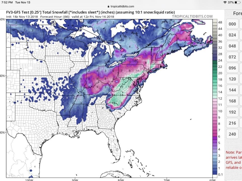
Well the 0z FV3-GFS just gave many of us our first and probably earliest fantasy winter storm.
-
3 hours ago, NC_hailstorm said:
100K still out of power in NC,good thing they had some sort of warning what was coming.
A tropical storm warning and then a severe thunderstorm warning for the “stinger jet” is what we received up here.
-
Its here!!!
-
1
-
-
2.23” yesterday, gusts to probably around 50-60mph did some damage locally.
-
It’s almost here!!!!!! Summer going out with a bang.
-
Stolen from internets...
-
https://en.m.wikipedia.org/wiki/Hurricane_Danny_(1997)
Due to a front behind the system, Danny unusually strengthened to a tropical storm over North Carolina on July 24. This rare phenomenon occurred due to interaction with a developing trough and its associated baroclinic zone.[1][2] Danny entered the Atlantic Ocean, north of the North Carolina-Virginia border, near Virginia Beach. It quickly reached a secondary peak of 60 miles per hour (100 km/h), and continued rapidly northeastward towards the waters of the Atlantic.
-
1
-
-
-
3 hours ago, jburns said:
Recommend a doctor. Dr. Daniels. Dr. Jack Daniels.
Dr MiGillicuddys.
-
Euro is putting down some unfortunate rainfall totals for eastern nc
-
38 minutes ago, WeatherHawk said:
Was enjoying a nice Pernicious IPA on King Street at the Boone Saloon today...went to the restroom...came back took a big pull on my cold brew and a darn old yellow jacket was in there...by the time I could get it out of my mouth it stung me all in my gums and my upper lip...6.5 hours later my upper jaw and lip are burning...any advice here to get the sting away???
Probably a wicked weed sour.
-
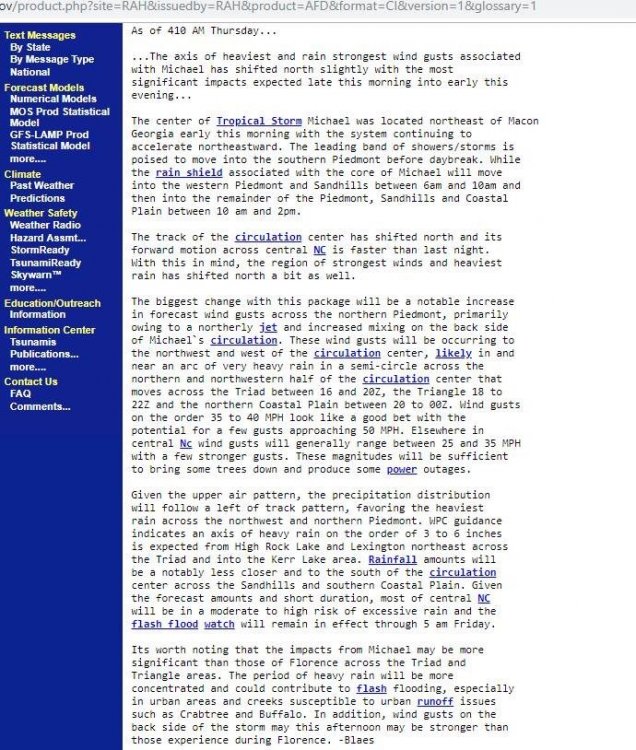
Lower dewpoints may get pulled in behind “Michael”.
-
Here’s something to look contemplate until our first snow event is 14 days away.
-
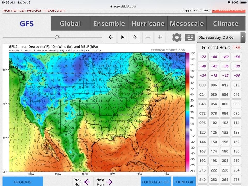
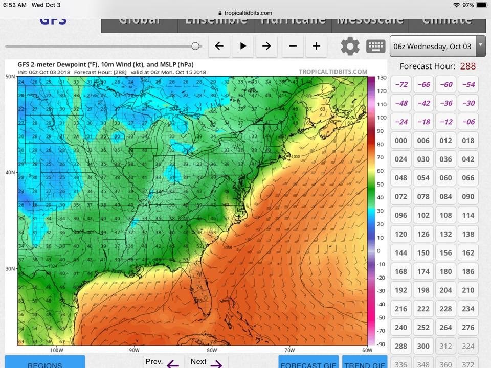
Were reeling this in! At 288hr
-
3 hours ago, Iceagewhereartthou said:
Yeah they continue to show the period around the 13th as promising so that it encouraging.
Only problem is that before that they were zoned in on the period around the 9th and 10th.
And before that it was the 5th and 6th that was going to be the real first front.
Except they had been touting the 2nd and 3rd as the change of airmasses.
But the end of September, 27th and 28th were going to bring the real relief.
But before that...

Indeed!
-
1
-


11/14/18-11/15/18 Winter storm/Flood (Ice/sleet) thread and obs
in Southeastern States
Posted
Wet rain, 36.9/35.9