

Isopycnic
-
Posts
14,563 -
Joined
-
Last visited
Content Type
Profiles
Blogs
Forums
American Weather
Media Demo
Store
Gallery
Posts posted by Isopycnic
-
-
All of my snow melted today.
-
2 hours ago, 40/70 Benchmark said:
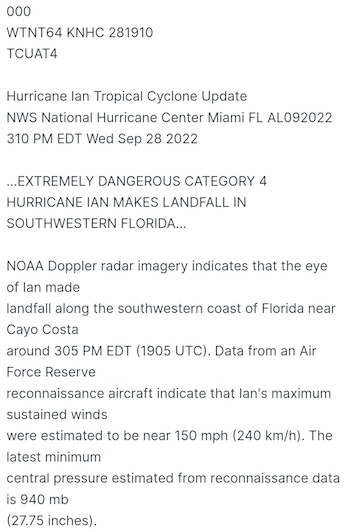
Just wanted to acknowledge how impressive the insight was throughout this thread during the evolution of this historic hurricane. I certainly learned a lot about intensity forecasting and undoubtedly much more to learn.
Here is my verification write up for those interested:
Hurricane Ian Verification Offers Mixed Results
Location and Timing of Landfall Forecast Nearly Flawless
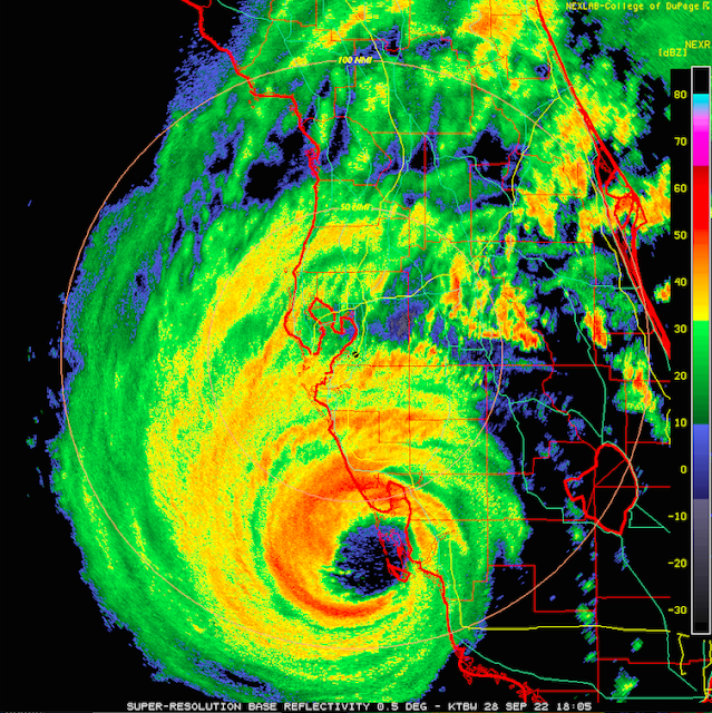
Here is how landfall of one of the most historic hurricanes in the history of the US, Hurricane Ian, evolved:
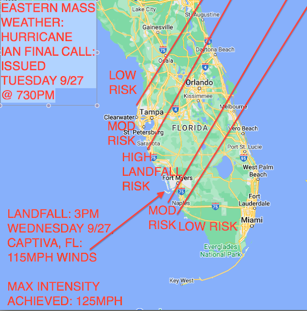
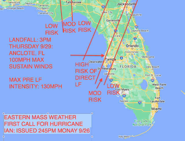
Versus the Eastern Mass Weather Final Call, issued at roughly 730pm on Tuesday night:
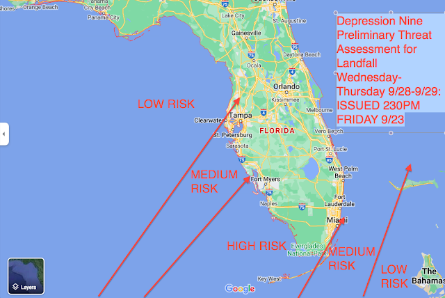
Fort Myers, FL was correctly identified as the most severely impacted major population center. Clearly the timing and location of the forecast was exemplary, having effectively incorporated climatology to disregard the consensus of guidance in the Monday night issuance of First Call:"Future Track of Ian Dependent Upon Interaction with Trough: Climo maybe the best ToolThe track forecast is high confidence until Ian makes it around the western periphery of the high pressure node that is currently steering it into the southeastern Gulf of Mexico.
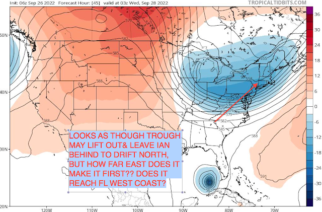
It is at this point that it will being to turn towards the north and potentially even north northeast, as we approach mid week and it becomes under the influence of the northern periphery of the ridge and the base of a trough to the north.
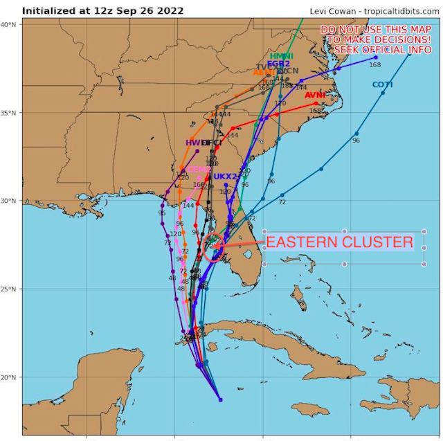
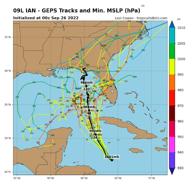
The primary question then becomes will it lose enough longitude to reach the west coast of Florida, or will it remain off of the coast (and how far) until reaching the panhandle...there is simply no way to know for sure and educated guesses will rule the day.Here is the guidance that will inform said "guesses":Hurricane Track Guidance and Global GuidanceNote the cluster to the east, in the general vicinity of Tampa...
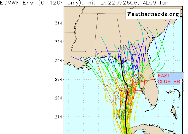
European Ensemble SuiteThere is similar cluster on the European suite, which has been admittedly biased to the east over the course of the past few days.GFS Ensemble Suite:
A similar, albeit less defined trend is noted on the GFS suite, as the western mean seems to be pulled by a scattering of western outliers, as opposed to a concentrated cluster.Canadian Ensemble Suite:
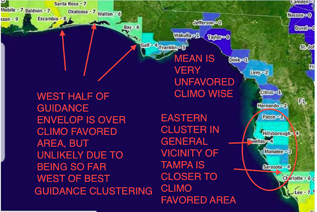
With such a stark dichotomy in forecast track, which is so crucial to intensity, as will be discussed momentarily, climatology may be the best guidance with respect to the future track of Hurricane Ian. And this is potentially grave news for the Tampa Bay metro area.Here is a graphic courtesy of Matt Gross, which lists all of the major hurricane strikes between 1900 and 2010 throughout the state of Florida.Note that the best guidance clustering is definitely within the eastern climo cluster, in the vicinity if Tampa. While it is too early to be confident, this is where the likelihood is highest at this point in time. All residents in this area should rush preparations to protect life and property to completion over the next couple of days. Especially since it is this eastern track scenario that offers the most intense landfall potential."While it was reasoned that the more eastern track offered a more intense scenario. as it turned out the forecast was not nearly intense enough.Landfall Intensity Forecast Left Much to be Desired
The logic all throughout the forecast period was that a more eastern track would result in a more intense hurricane strike.
But complicating matters was that interaction with the higher terrain of wester Cuba induced a premature Eye wall Replacement Cycle (EWRC) as it re emerged int the se Gulf of Mexico.
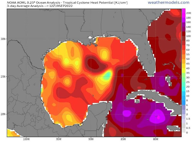
The forecast final forecast philosophy was that while the further south and east track would avoid much of the shear and dry air intrusion, these inhibiting factors would become just prevalent enough prior to landfall to retard the ability to the hurricane to fully recover from this EWRC. Thus it was not forecast to intensify significantly prior to landfall. However, Ian ended up recovering just about as proficiently and quickly as physically possible, and this coupled with the fact that its size allowed to be virtually impervious to the marginal mitigating factors allowed to take full advantage of some very high octane oceanic heat content. While this was alluded to as a possibility in the Final Call, it was not forecast."The one caveat that bares watching is that if Ian should complete the aforementioned EWRC and conditions are not prohibitive to intensification, the oceanic heat content is very high just off of the coast of Fort Myers, so the possibility of late intensification, though not forecast, can not be ruled out.Thus the forecast intensity of 115mph was well short of the verified 150mph maximum sustained winds at landfall.
FINAL GRADE: C
Thanks Ray! Awesome.
-
 1
1
-
-
22 minutes ago, kvegas-wx said:
I look at it the other way around, a big VD snow means I aint gotta take her out and she can cook me a big ole sketti dinner. I will build the fire though.


-
1 hour ago, WinstonSalemArlington said:
I’m looking forward to my 0.01” of sleet
-
 1
1
-
-
24 minutes ago, burrel2 said:
eyore is a fictional character in the Winnie-the-Pooh books by A. A. Milne. He is generally characterized as a pessimistic, gloomy, depressed, anhedonic, old grey stuffed donkey
sums up eyewalls general demeanor every winter, lol
I miss widremann
-
5
-
-
1.9” snow. 0.19” of liquid equivalent. 2.1” now in the yard .
-
2
-
-
20 minutes ago, Brick Tamland said:
Finally started snowing
Thank f’ing gawd!
-
1
-
8
-
-
5 minutes ago, Brick Tamland said:
Wow, we keep having these threats showing up about 7 days after each other. Been a long time since that has happened.
Yeah, last winter.
-
4
-
10
-
-
5 minutes ago, Grayman said:
Does anyone have time to post a link to the best site for nowcasting? Someone posted SPC mesoscale but honestly I’m still learning and don’t know exactly what I’m looking for. Thanks
-
 1
1
-
-
31.7” rain gauge started tipping.
-
Almost 2” of sleet and snow before changeover to freezing rain. Temps rising fast.
-
Changed to freezing rain .
-
Heavy sleet baby!
-
Moderate sleet b!tches!
-
Snow but transitioning to sleet. You can see the transition on the correlation coefficient on the radar.
-
2
-
-
Moderate snow with 1/2” accumulation west Durham. Roads are white
-
Reminder.use the mPing app to report your conditions.
-
3
-
-
Light snow western Orange County south of hillsborough on pickards mountain.
-
2
-
-
21 minutes ago, Brick Tamland said:
BrickistheGOAT
BRICKtheWEENIE
-
4
-
5
-
 1
1
-
-
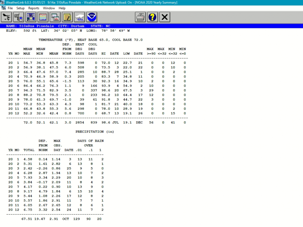
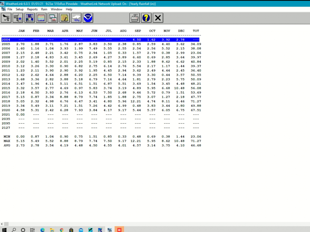
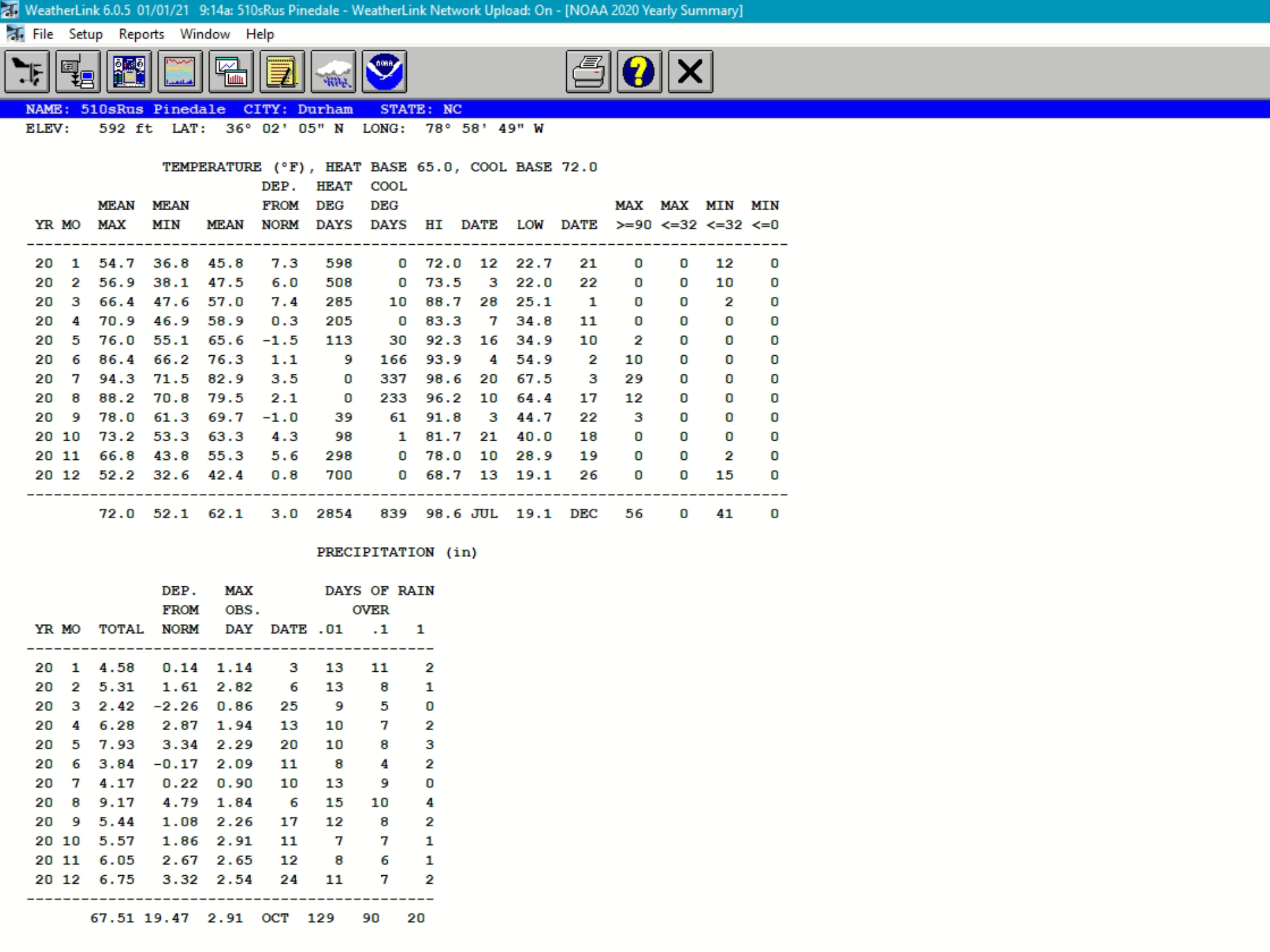
Happy New Year!
2021 weather stats from my front lawn.
Calendar year 2021 statistics:
Mean Temp: 61.5f (+2.3f)
-----------------------------------------Max Temp: 96.7f
Mean Max: 72.0f
-----------------------------------------Min Temp: 21.3f ( Thats not very cold… :0 )
Mean Min: 51f
------------------------------------------Rainfall: 42.70” (-5.34”)
Snowfall: 0.19”(0.19” 2019/20 season)
-
3
-
-
Warm, wet. .. COVID.
-
1
-
-
2.09” yesterday. Most of it falling in an hour. Some areas a mile or two north of me had 6+ inches.
-
0.74” from Bertha
-
On 5/21/2020 at 6:04 AM, Isopycnic said:
5.70” storms total. Still pouring.
6.43”


February 19-20 Major Winter Storm Threat
in Southeastern States
Posted
Totaled 3.8” or so