jewell2188
-
Posts
550 -
Joined
-
Last visited
Content Type
Profiles
Blogs
Forums
American Weather
Media Demo
Store
Gallery
Posts posted by jewell2188
-
-
Just now, snjókoma said:
Still all snow here. Are people confusing rimed flakes for sleet?
Deff mixing with sleet in falls church
-
-
Just now, EastCoast NPZ said:
Yes. Went outside to check. All sleet.
Radar confirms this. All sleet in Warrenton va. It’s moving pretty quickly northward.
-
 1
1
-
-
Roads caved so fast, makes you think even harder about the waste of tax payer dollars to pretreat roads.....rant over
-
Ripping in falls church.
-
 1
1
-
-
So to the untrained eye, are we going to be looking at the radar to the south for precip to start filling back in?
-
-
The dry air trolling on twitter is real right now....what storm do we never account for the initial dry air battle

-
5 minutes ago, DCTeacherman said:
Yeah, it’s a pretty brutal way to go about it. They should really just make a forecast.
It just gives them the ability to never be “wrong”
-
Right on que, CWG lowers amounts again....dry air will delay the onset apparently.
-
2 minutes ago, yoda said:
Updated AFD from LWX as of 8:57pm:
I like that they are rather confident in the 3-6 95 westward.
-
 1
1
-
-
Just now, jaydreb said:
No one likes to see bad runs but we should be using the Euro 1000 times more than the HRRR. I know you all know this.
Pretty sure the nams would be more useful at this range versus euro or gfs
-
Most Mets across the area have lowered or settled with 2-4 inches. Seems reasonable but I do feel the bust potential is quite real.
-
 1
1
-
-
I think most can agree 2-4 inches is a good call area wide. Kinda reminds me of the mid November snow we had....I think totals ranged from 1-3 with some 4 inch amounts before it change to sleet and rain eventually.
-
1 minute ago, snjókoma said:
3K NAM is a bit of a disaster for DC and south. Area of best rates lifts north very quickly. We're still snow at 15z but verbatim its very light.
Edit: Perhaps disaster is too strong of a word... it still looks like 2-3". just a very unimpressive thump.
Back and forth back and forth. When does this nonsense stop? “Disaster”....what were you really expecting from this? Can we let the models play out before making assumptions.
-
I guess NWS will update watches in the morning package?
-
5 minutes ago, jaydreb said:
Thanks. QPF is solid. But temps are the problem.
Maybe for your location.
-
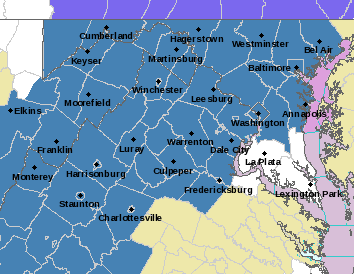
Winter storm watches are up!
URGENT - WINTER WEATHER MESSAGE
National Weather Service Baltimore MD/Washington DC
338 AM EST Mon Feb 18 2019

DCZ001-MDZ003>006-011-013-014-501>508-VAZ025>031-036>040-050>056-
501>508-WVZ050>053-055-501>506-181645-
/O.NEW.KLWX.WS.A.0005.190220T0300Z-190221T0300Z/
District of Columbia-Washington-Frederick MD-Carroll-
Northern Baltimore-Southern Baltimore-Prince Georges-Anne Arundel-
Extreme Western Allegany-Central and Eastern Allegany-
Northwest Montgomery-Central and Southeast Montgomery-
Northwest Howard-Central and Southeast Howard-Northwest Harford-
Southeast Harford-Augusta-Rockingham-Shenandoah-Frederick VA-Page-
Warren-Clarke-Nelson-Albemarle-Greene-Madison-Rappahannock-Orange-
Culpeper-Prince William/Manassas/Manassas Park-Fairfax-
Arlington/Falls Church/Alexandria-Stafford-Spotsylvania-
Northern Fauquier-Southern Fauquier-Western Highland-
Eastern Highland-Western Loudoun-Eastern Loudoun-
Northern Virginia Blue Ridge-Central Virginia Blue Ridge-
Hampshire-Morgan-Berkeley-Jefferson-Hardy-Western Grant-
Eastern Grant-Western Mineral-Eastern Mineral-Western Pendleton-
Eastern Pendleton-
338 AM EST Mon Feb 18 2019

...WINTER STORM WATCH IN EFFECT FROM TUESDAY EVENING THROUGH
WEDNESDAY EVENING...

* WHAT...Heavy snow, mixing with and eventually changing to sleet
  and then freezing rain. Snow accumulations of 5 or more inches
  and ice accumulations of a quarter-inch or greater are possible.

* WHERE...The District of Columbia, Maryland east of the
  Appalachians and west of the Chesapeake Bay, central and
  northern Virginia, and the eastern West Virginia panhandle.

* WHEN...From Tuesday evening through Wednesday evening.

* ADDITIONAL DETAILS...Travel could be very difficult. The
  hazardous conditions could impact the morning or evening
  commute.

PRECAUTIONARY/PREPAREDNESS ACTIONS...

A Winter Storm Watch means there is potential for significant
snow, sleet or ice accumulations that may impact travel. Continue
to monitor the latest forecasts.

&&

$$

HTS
-
 3
3
-
-
Just now, C.A.P.E. said:
Congrats Ohio. Enjoy your thump.
We are either losing our thump or it was never real to begin with
-
Just now, snowmagnet said:
VDOT brined the roads in Fairfax Co last Thursday for our weekend storm that went south.
A classic example of wasting tax payer money. And another example of “use the budget or lose it next year”
-
 1
1
-
-
Just now, LP08 said:
The main moisture plume is pushed to our north and west. SE ridge is flexing...just another way to fail...we always find a way lol
-
24 minutes ago, Deck Pic said:
depends where you live and what your expectations are...If some folks up I-270 get 6-8" and then ice, that's a pretty good storm imo
It’s a level 1 storm for vdot in nova. Not enough to bring all my plow trucks out of hiding....=disappointment

-
The king just said sit down

-
 1
1
-
-
3 minutes ago, stormtracker said:
Wes is here, everybody drink. It's officially a party.
And you are correct, that ludicrous map does include sleet. If we can manage 2-4 before the changeover, I'm good.
What are the chances of the “thump” over achieving like we’ve seen many times around here!?


February Banter 2019
in Mid Atlantic
Posted
I work for a company that has a vdot contract for snow removal in Fairfax County (merrifield) to be exact, ive been doing it for 9 years now and it amazes me the amount of complaints from citizens whether it’s a large storm or small. If most truly understood the amount of time and hard work that goes into trying to keep roads clear, not one person would say a word. Not to mention the folks who just can’t seem to stay off the roads during snow.....let’s be honest, with the amount of closings yesterday 95% of the traffic had no reason to be out lol. Rant over !!!