

Physicsteve
-
Posts
46 -
Joined
-
Last visited
Content Type
Profiles
Blogs
Forums
American Weather
Media Demo
Store
Gallery
Posts posted by Physicsteve
-
-
32 minutes ago, JERSEYSNOWROB said:
Finally got my two inches. What a struggle it has been. Hahaha Incredible to hear about those amounts just to my north! Congrats everyone!
Seems like folks around rts 78 and 22 maxed out. What a difference 25 miles (for me) makes! Currently getting some of Agnes’ light snow blob. Maybe another shower or squall later if they can make it across PA.
-
Unofficially officially 3.5” on the trash can lid near the house and 2.5” on the driveway. Some quick differential equations averages that to 3” as of 5am
-
6 minutes ago, Ralph Wiggum said:
Whoever is S of that band thru N Bucks is going to fall victim to the subsidence. Could be a sharp cutoff between 5" and just an inch "or so".
Yeah @Blue Dream and I will be sweating it if that 3k verifies. WWA here for now. Makes it dicey whether to stay up late or wake up psychotically early to watch. Sunny and 41 for now
-
Padding some stats with a moderate burst of nickel-sized parachutes the last 15 minutes or so.
-
 1
1
-
-
2 minutes ago, Blue Dream said:
2-3” here in Morrisville. Not a lot of accumulation the past hour. Hopefully it picks up again soon.
Yeah, basically across the river from you and measured 3" of mashed potatoes on the driveway not too long ago. Agree it's let up but hoping we get some stat padding on the way out. Glad I dug out the snowblower but now have to change the oil since it's been a while.
-
1
-
-
First flakes started mixing in around 6 here and everything was coated, street and asphalt driveway included, once it was all snow by 6:30. Moderate to heavy snow currently, and eyeballing 2" on patio table and chairs.
-
2
-
-
Rain and sleet mix at the moment, with some sort of icy accumulation/accretion on the cars. Eagerly awaiting a change to snow.
-
1 minute ago, RedSky said:
1.7" confirmed this is going to smoke my expectations
Same. I don't know if Im just content bc snow’s falling or bc in self defense I had severely tempered expectations after losing the bullseye to the southern shift in the last 24 hours. Either way, I take.
-
4
-
-
Light snow since 6am eyeballing 1.5 maaaaybe 2” near Washington Crossing. Mod to heavy to maaaaybe ripping for the last 10 minutes or so. As I write intensity hasn’t slowed but flake size has.
-
Spotty mulch topper so far just NW of trenton. Currently pixie dust so r/s line seems pretty good. Wish it were further away!
-
 1
1
-
-
Adopted a rescue yesterday who’s not house broken so this afternoon and evening should be fun going outside every hour or so. Hoping for enough remaining precip and dynamics to wake up to some snow falling during the morning attempt(s). Think some slush otg is all I can expect here but rooting for the W/NW crew to cash in on some measurable depth. Go Birds!
-
3
-
-
Snowage in Titusville per wifey
-
3
-
 2
2
-
-
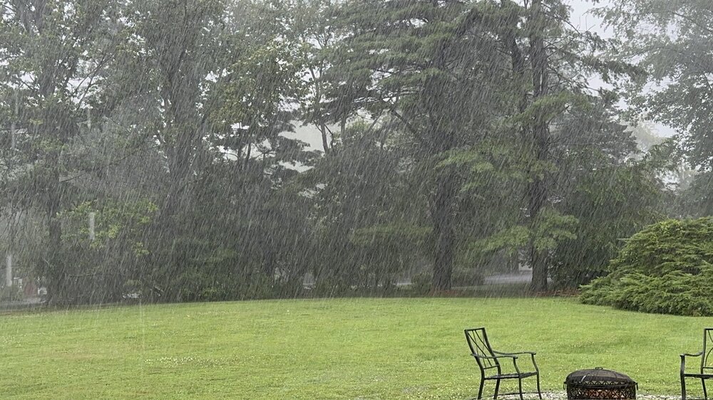
Not sure what the compressed file will look like but a wall of rain for about 75 minutes, with a 10 minute “lull” throw in there
-
5
-
-
Monsoon-like rains and frequent ctg boomers for the past half hour or more in titusville, near Washington crossing. Impressive stuff
-
2
-
-
Noticed many shrubs and dogwoods budding at our new digs in Titusville (near Washington Crossing) yesterday, this morning daughter and I awoke with allergies, and there are no less than 9 robins having breakfast in the backyard.
Obs: spring
-
Agreed. Not that it's the same up top, but for now seems like best case end result will be a lesser version of 1/28-29 to these novice eyes. Again lots of moving parts and interactions that won't start to be well-modeled until tomorrow imo. Who do we have to speak to in order to get some blocking?! Is this still from our winter-for-Super Bowl sacrifices from '17-18? (Worth it)
-
Any obs from the Poconos area? Supposed to be up near Gouldsboro tomorrow morning and wondering how the conditions and infrastructure are faring? Are conditions better, same, or worse than progged? Thanks and sorry for the me-centric post
-
 1
1
-
-
I'm a novice at best so there's the caveat, but based on my understanding of psu's analysis last night looks like the pieces are playing together relatively nicely and piece 'A' has a North-South orientation rather than NW-SE that gfs wide-right was showing. I liked how that example still had a N-S component and wasn't all 'diagonal', which is hopefully closer to reality.
-
1 hour ago, bluewave said:
We haven’t seen a complete P-type bust from the day before for a major event in a while. The most memorable one for me was 1-20-78. The forecast from the day before was for rain heavy at times. The next morning we had 12-18” on the ground.
But I guess the term bust can be highly subjective.
My parents got married the next day and had to use my dad’s brother and wife’s rings because theirs were stuck at the jewelers (don’t know why they cut that so close). The way they tell it it started as snow but was supposed to flip to rain overnight but never did. I keep that hope alive whenever in a marginal temp situation.
-
2
-
-
12 minutes ago, gravitylover said:
We haven't had a good ol' 4 Corners Low come bowling across the country in too long. It sure would be nice to see one again.
Encouragingly it’s been a persistent feature for a few runs on a few models. We’ll see!
ETA: To be clear, it doesn’t stay closed as it moves East. Just wonder how when and where that energy eventually interacts will shape things.
-
1
-
-
6 hours ago, MJO812 said:
Vorts all over
We will get something
There’s a vort that breaks off from the northern stream over the weekend that closes off and spins over Baja Peninsula and AZ for a day and a half or so before finally moving East into the flow with everything else. I think how that split goes and actual duration of that vacation in the SW determines how next week goes.
-
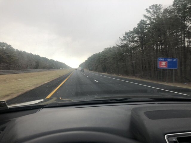
Can confirm as I drove across 195 about an hour ago there was what I would struggle to call a squall around exit 22ish.
-
1
-
-
I guess that’s why ‘96 gets all the hoopla, and my memory is as bad as my wife says it is. Either way, it was the first big snowstorm I saw, and a weenie was born.
-
1
-
-
I imagine most of us had some winter event during our formative years that started our love for snow (and the weather channel at the time) and this is that storm for me. I grew up in Washington Township, NJ, about 10 miles SE of Philly (yo, @BBasile!) and was 9 years old at the time. Relying on my childhood memories, an unreliable source to be sure, I think we got about 2 feet. I couldn't imagine any more snow until my Uncle reported about 3 feet up in Vernon, NJ. That was my first taste of jackpot jealousy which I’m just now getting over. I can finally just appreciate storms for what they are and not worry about getting the most snow possible. Only took about 28 years...
I think I remember some sleet mixing in (could've been ‘96, or both) during the middle of the storm, but luckily wasn’t aware enough to get worried about it impacting totals or warm noses or anything. It didnt last long, from what I remember. Maybe an hour or two. I went out sledding with some friends pretty early on in the storm, which was awesome to be out in and was probably the only opportunity before there was simply too much for a sled to work.
I lucked out being too young/not knowing any better in the 80s during the dark days @RedSky has flashbacks about, but was young and impressionable for ‘93, ‘94 ice bonanza, and ‘96. ‘96 always seems to get the most hoopla on this site, but you never forget your first, and for me that was ‘93.
-
2
-
1
-

The Official Unofficial Overnight February 16/17th Snow/OBS Thread
in Philadelphia Region
Posted
Stolen from the MA forum re: deathband
https://www.americanwx.com/bb/topic/60042-the-weekend-rule-saturday-217-the-icon-storm/?do=findComment&comment=7226648