garfan
-
Posts
43 -
Joined
-
Last visited
Content Type
Profiles
Blogs
Forums
American Weather
Media Demo
Store
Gallery
Everything posted by garfan
-
MO/KS/AR/OK 2019-2020 Winter Wonderland Discussion
garfan replied to JoMo's topic in Central/Western States
I saw a video on Twitter of snow coming down that mentioned NW AR. The NWS Tulsa asked the person who posted it where it was taken. They replied Rogers, AR. -
MO/KS/AR/OK 2019-2020 Winter Wonderland Discussion
garfan replied to JoMo's topic in Central/Western States
Thank you both StormChazer and JoMO for the lesson here. It makes sense now. -
MO/KS/AR/OK 2019-2020 Winter Wonderland Discussion
garfan replied to JoMo's topic in Central/Western States
I am always trying to learn more in regards to forecasting. I even read AFD's and take notes when something is mentioned I have never heard before. 'StormChazer' you mentioned above "faster means more cold air sticking around". Care to share why is that so? I just assumed that faster would relate to warmer, and that less precip would have time to fall. If this is the wrong place in the forum to ask, forgive me. -
MO/KS/AR/OK 2019-2020 Winter Wonderland Discussion
garfan replied to JoMo's topic in Central/Western States
Anyone else look at the NWS Little Rock AFD from January 1 2:55 PM? It was very lengthy and detailed regarding the upcoming winter weather potential in Arkansas. -
MO/KS/AR/OK 2019-2020 Winter Wonderland Discussion
garfan replied to JoMo's topic in Central/Western States
I just looked, sadness. Too me it looks less of a threat over central Oklahoma. The NWS Norman, OK might have to back off on the Winter Storm Watch. -
MO/KS/AR/OK 2019-2020 Winter Wonderland Discussion
garfan replied to JoMo's topic in Central/Western States
I don't take the freezing rain maps numbers verbatim. But what I do watch for are trends where the lighter precip versus heaviest precip amounts might fall. -
MO/KS/AR/OK 2019-2020 Winter Wonderland Discussion
garfan replied to JoMo's topic in Central/Western States
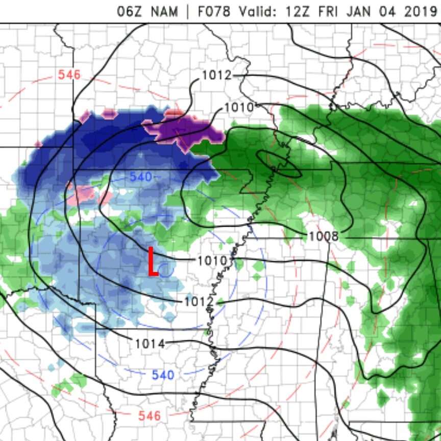
If the NAM is close on some of those projected freezing rain totals that spells a lot of trouble for the OKC metro and other places as well. From what I understand, 0.25" is the threshold for the beginning of tree damage and power outages. Lesser amounts of course for roadway headaches. -
MO/KS/AR/OK 2019-2020 Winter Wonderland Discussion
garfan replied to JoMo's topic in Central/Western States
I know some TV mets cringe when the NAM is brought up for use in forecasting. Anyway, I like using it, and I am aware of some of its biases. Last winter season it was right on more than one occasion. -
MO/KS/AR/OK 2019-2020 Winter Wonderland Discussion
garfan replied to JoMo's topic in Central/Western States
There is Winter Storm Watch in place in much of central and western Oklahoma. About an hour ago the NWS Norman, OK tweeted this... "There is still some uncertainty with the forecast for the upcoming winter weather Wed. night into Thursday. The models have trended the system slower, warmer, and further south, all of which impact winter precip amounts and location." -
MO/KS/AR/OK 2019-2020 Winter Wonderland Discussion
garfan replied to JoMo's topic in Central/Western States
At this time rooting for the 06Z NAM. Southern MO and Northern AR often sees some of it's better snows when the storm track pivots northeast around the Texarkana/Ft. Smith area.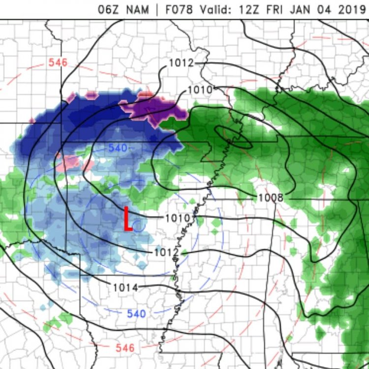
-
MO/KS/AR/OK 2019-2020 Winter Wonderland Discussion
garfan replied to JoMo's topic in Central/Western States
Tweet earlier today from Meteorologist Damon Lane at KOCO having a little fun. "Oklahoma Metorologists: if you speak the snow storm into existence, then it will vanish." -
MO/KS/AR/OK 2019-2020 Winter Wonderland Discussion
garfan replied to JoMo's topic in Central/Western States
I like the image above, but there is no way that will happen. I do find it odd, but slightly humorous that the Oklahoma TV stations at least on social media (Facebook/Twitter) are pretty quiet about what might happen regarding this potential winter event. -
MO/KS/AR/OK 2019-2020 Winter Wonderland Discussion
garfan replied to JoMo's topic in Central/Western States
The weather office in Springfield, MO not totally sold on what the ECMWF continues to suggest. -
MO/KS/AR/OK 2019-2020 Winter Wonderland Discussion
garfan replied to JoMo's topic in Central/Western States
I don't post very often on this forum, but I plan to do more at the beginning of the year. I have been watching a trend of the forecast models (GFS/ECMWF) and they do suggest some light wintry precip in parts of the western Ozarks region around the first of the year. Merry Christmas everyone! -
Central/Western Medium-Long Range Discussion
garfan replied to andyhb's topic in Central/Western States
The 18Z GFS for Sunday looks more interesting than previous runs. -
MO/KS/AR/OK 2019-2020 Winter Wonderland Discussion
garfan replied to JoMo's topic in Central/Western States
Roads in and around the Joplin, MO area have deteriorated as they day has progressed. Freezing drizzle has been primary precipitation type.