

512high
-
Posts
2,191 -
Joined
-
Last visited
Content Type
Profiles
Blogs
Forums
American Weather
Media Demo
Store
Gallery
Posts posted by 512high
-
-
3 minutes ago, 40/70 Benchmark said:
Yea, don't need a great track to get buried in that one....just for jackpot. And before anyone asks, yes....I am satisfied after that last one. If I get another one great, but I would like to get you coastal guys on the board.
Ray, didn't you state somewhere(not sure what thread) that you thought coastal areas should see some action ? Not sure what analog/dates you mentioned etc. (1987?) I could be off....
Edit: With that said, I have a client Rye Beach,NH on the ocean, he got may 1.5", 4 miles down the road 13-16" last storm
-
Wow home Davis at home 13F pretty sure my new low so far.
-
 1
1
-
-
2 hours ago, 40/70 Benchmark said:
Sunday Snow Forecast Fairly Well
Amounts Slightly Heavier Inland and Lower Than Forecast Immediate Coast
Here are the snowfall amounts from yesterday's storm versus the Eastern Mass Weather Final Call.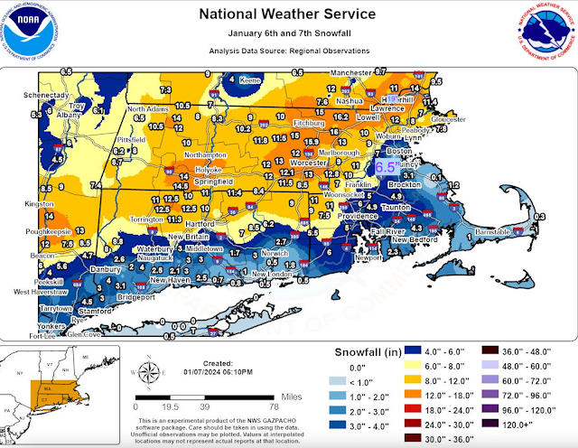
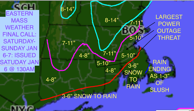
The forecast overall was a high quality effort, however, there were two glaring issues.
1) The 8-14" area of maximum forecast snowfall, while generally accurate, would have been better served to reflect 12-18" and be positioned ever so slightly to the south of where it was in the forecast. There also should have been a secondary area over northwestern Connecticut.2) The more glaring error was the forecast for 5-10" along the immediate coast in the densely populated Boston area, whereas the lower levels remained warm enough to limit accumulations to as low as 3.1" at Boston's Logan International Airport. However, amounts of over 6" were observed just away from the ocean (6.5" Brookline, MA) in the Boston area, as well as over interior southeastern Mass (6.25" in Taunton, MA). Suffice to say, the gradient along the east coast was not quite sharp enough to reflect the thermal changes from the marine influence.Final Grade: B+Great job, can't remember a 16" event in quite awhile ...good stuff!
-
1
-
-
1 hour ago, CoastalWx said:
Still looks inverted on soundings.
And hopefully a quick mover....
-
1
-
-
1 minute ago, dendrite said:
I stole your snow.
But honestly that forecast wasn’t too bad. If you looked at the point forecasts that 12-18” was more like 13”. And your depth of 9” is probably more like 10-11” if you cleared every 6hrs. But there were many locations up here and in S NH over a foot.
Agreed. I think NWS was a good call, good event
-
Just now, DomNH said:
That’s what I figured. I’m downtown and eyeballed the same. Nice to see a NEMA/SNH jack.
Finally! Its been a while, worked out great where it was on a weekend too!
-
3 hours ago, DomNH said:
@512high how much do you have? I don't have a spot to measure but eyeballing like 12-14'' or so settled.
Sorry Dom for the delay, my shop on Simon st(exit 5 area) one spot at 530pm I had 15.5" or so, home(off south main st) had 16"+/_
-
1 hour ago, Chrisrotary12 said:
eyeballing 5-6" out front window. pixie dust falling now. on track for my forecast of 8".
Edit: measured 5”
Chris, my shop at exit 5, measured 7.50" two locations, my home 8", however it was gusty overnight....
-
about 5.5", temp now 25F and snowing!
-
2
-
-
3 minutes ago, STILL N OF PIKE said:
If KBED flips to rain I’m heading to ASH
Take ur time..... 1" on the roads, 32F light wind, at my shop exit 5 waiting for the radar to fill in I hope....
-
1 minute ago, 40/70 Benchmark said:
I'm just breaking your balls lol Nothing unreasonable about that.
Don't alter your final call, too much.....
-
Ya , wind now picking up, clouds, 38F zero snow here
-
Like Greg said, Thanks for taking the time to do this, hope to have many more of your outlooks all winter!
-
1
-
-
1 minute ago, CoastalWx said:
I think the biggest issue is to develop more confluence to our north. I don’t think it prevents us from flipping to rain, but it could help lead to a colder front end and keep NNE frozen. I thought the euro took a step that way.
I know the 10th is a ways out, temps yesterday looked 40-45F? Not sure the amount of precipitation , but afraid we would loose whatever pack we start to establish for us SNE. I know, one thing at a time,
-
3 hours ago, kdxken said:
Where is the Effin sun I was promised?
Sun and clouds here for the last 30 minutes........34F At least it's no raining right now!
-
2
-
-
Just now, CoastalWx said:
wtf does that mean? Pounds of time?
waiting for snow?
-
Boy for the wennies that drink here, will be tossing them back tomorrow night, no snow, gosh I don't think I have seen the sun in 6 days? 41/ hvy drizzle
-
2 minutes ago, weatherwiz said:
Flying back to snowless CT. TV in the flight doesn’t work, charging outlet doesn’t work, and it’s a bit of a bumpy flight and I have a massive headache
Too many beers and cigars! lol
-
 3
3
-
-
56 minutes ago, ORH_wxman said:
Kind of weird that the 00z Euro suite basically got rid of the 1/5 storm while other guidance all has it.
The 06z EPS did bring it back a decent amount just looking now. Not sure what was up with the 00z run.
The 00z EPS did have a number of decent hits for 1/7-8 again despite OP being south and wide right. Something to watch still…esp for southern peeps.
See, that is what I said to Tip yesterday, "here today, gone tomorrow", Just seems to be a lot of clutter in runs this winter vs. last winter? I don't know..
-
3 minutes ago, Typhoon Tip said:
Noticeably more aggressive diving the N/stream out of Ontario though - that's allllmost ominous.
The problem (the way I see things...) is that the total trough space, inside of which the N/stream and S/stream are flirting with having integration, is progressive and doing so too fast. They ultimately do phase, but the playground itself has move away from our area before it means much here.
This is actually a hemispheric problem, too. Every thing on that chart is bodily moving unusually fast down stream.
I'm not sure if this can modulate better ... I mean it's 7 days away. But even 6 hours slower and a slightly fast N/stream plunge is pretty much all that would take to clip the coast from NYC-PWM with the season's first
Tip, I'm really confused with all the model runs the last few days I think it was you and others a few days ago or so, "sniff" something to watch around 1/5, then, and I could be wrong, I thought I read somewhere pages back, that the 1/5 was gone, and now a possible 1/8 or 1/9, another words did 1/5 disappear this am, and is now popping up ? What is going on with models, or is shit just moving too fast, seems a lot of clutter...
-
I maybe "off" a inch or so on the accumulations for last season, (2022-2023) For Nashua, NH
Nov. 16, 2022=Trace of snow
Dec. 12, 2022=1"
Dec.16, 2022=Slush
Dec.23,2022=Slush/Rapid Freeze
Jan. 6, 2023=1" Slush
Jan.12,2023=1" Slush
Jan. 16,2023=3"+/_
Jan. 20,2023=5"+/-
Jan.23,2023=5"+/-
Feb.21,2023=2"
Feb.23,2023=4" w/change over..Icy
Feb. 28, 2023=3"
Mar. 4, 2023=6.5" +/_
Mar. 15,2023=9"+/-
I'm just hanging on, no other choice, no control over it, just stop the freaking Rain!
-
2
-
-
42/ .11" since midnight
-
1
-
-
6 minutes ago, Layman said:
Spent a few days away to rest and relax - checking in to see what’s happening.
Anyone else notice how warm and rainy it’s been?
41.0 and 0.10” rain as of 6:45am
lol go back and read the last 30 pages!
-
1 minute ago, Typhoon Tip said:
Lol... awesome. 6 days until January, and already the January thread has canceled January.
Man, the addiction crisis in here may have reached a historic fever.
Pretty much! And Feb. 1st or so, I will hear you saying how warm your car seat is.....


January 2024 -- Discussion
in New England
Posted
Ray I just sent a text, he said it was very warm at the beginning of the storm, his final total was 8.5", he claimed he picked up 6 inches or so second part of storm until late pm....