

*Flash*
-
Posts
762 -
Joined
-
Last visited
Content Type
Profiles
Blogs
Forums
American Weather
Media Demo
Store
Gallery
Posts posted by *Flash*
-
-
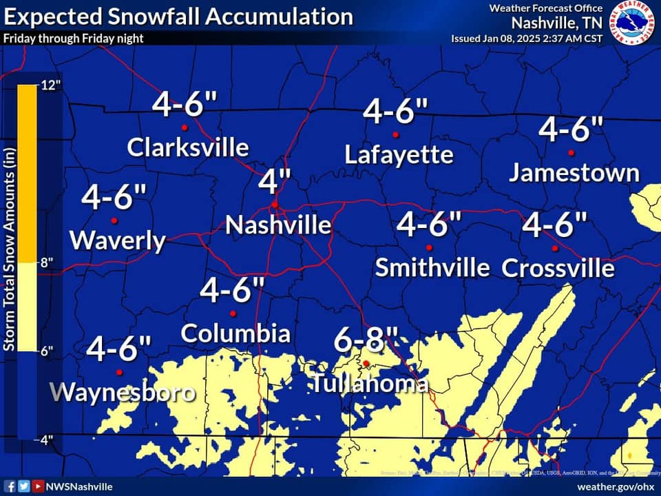
Great write-up by NWS-Nashville.
https://www.weather.gov/media/ohx/briefing/SitRep.pdf
Also, I can't help but notice the entire state of Tennessee is in a Winter Storm Warning. Archiving the current NOAA alert map below for future reference.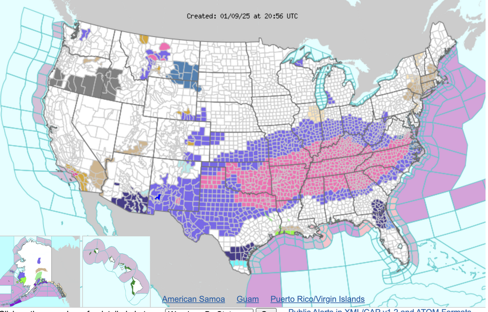
-
 7
7
-
 1
1
-
-
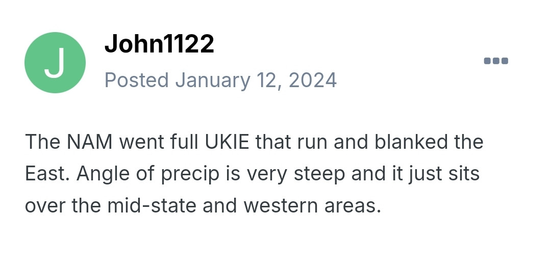
29 minutes ago, John1122 said:
This is from last January when the NAM was about 48-60 hours out and it suddenly decided to have East Tennessee in the 50s in a dry slot after it made a jarring NW jump.
Oh no. Hate speech!
") Jk, jk.
Jk, jk.
-
-
Nice graphics by OHX...
-
5
-
-
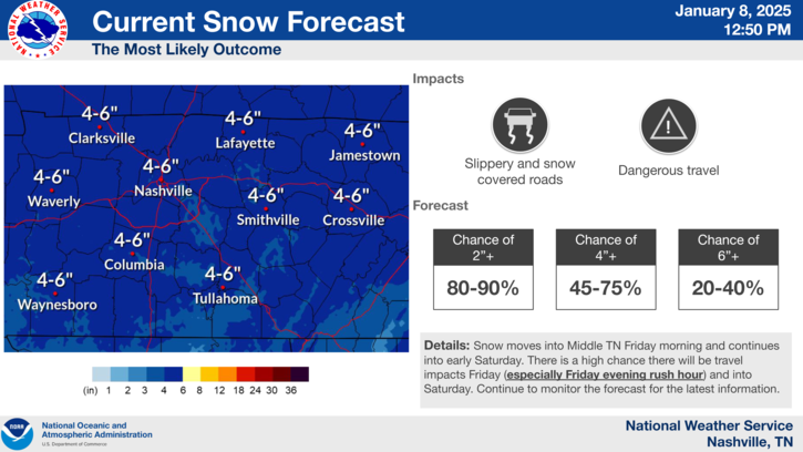
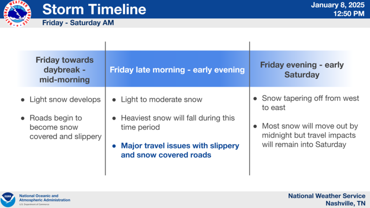
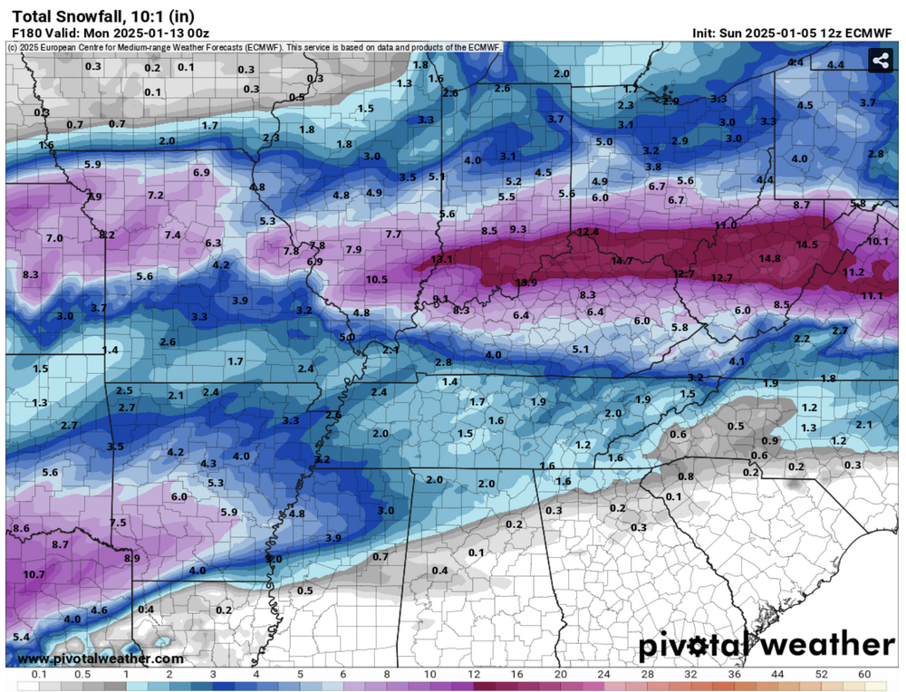
Didn't see this posted earlier so figured I'd share for archiving purposes. I think totals are a bit high for northwest suburbs unless I'm missing something.
-
2
-
-
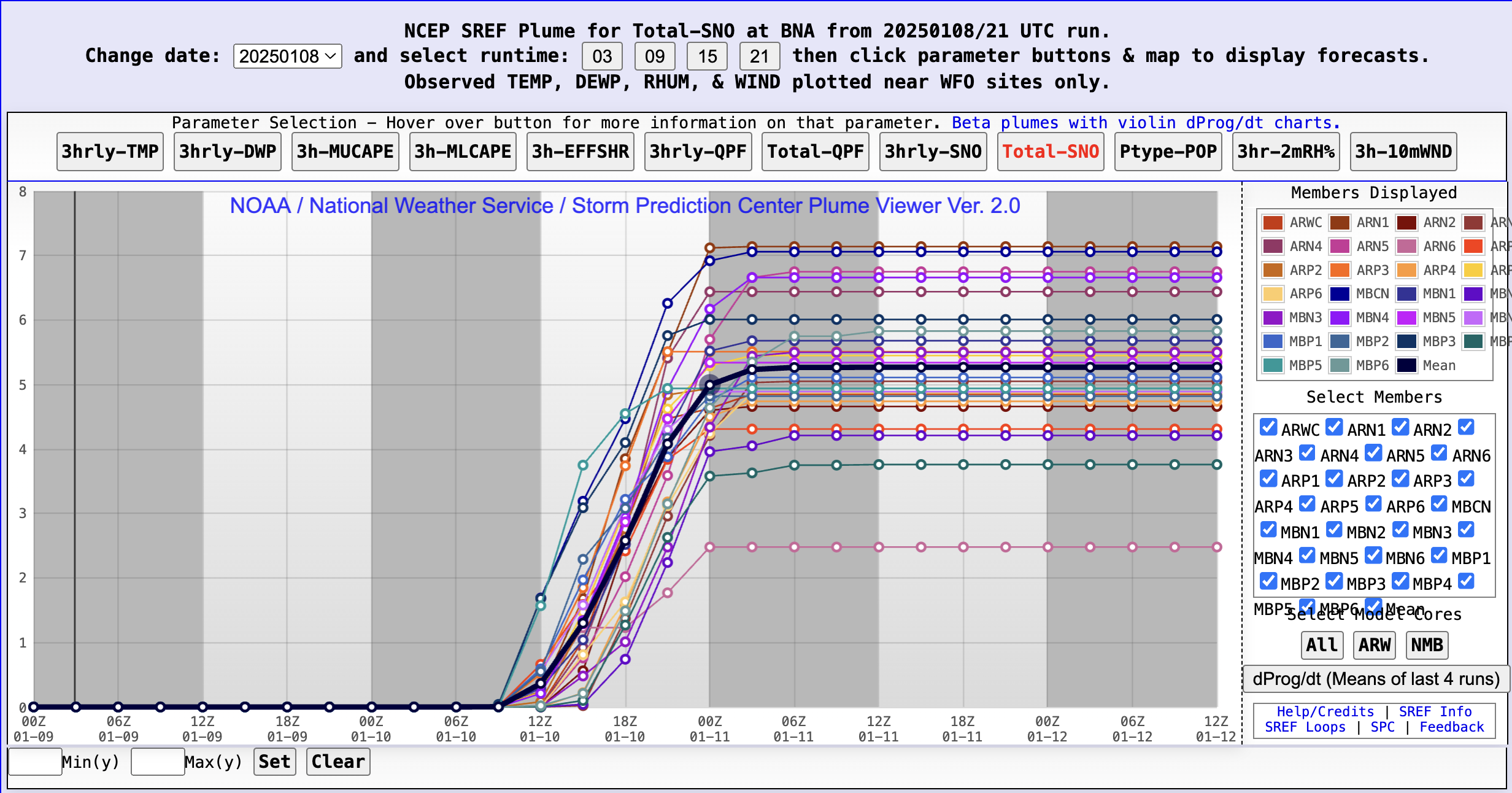
Yeah, it feels weird saying but I’m not sure I’m buying the Euro at the stage. Almost to the 60 hour threshold so hopefully higher resolutions will start to unveil a clearer picture. FWIW, SREF Plumes have a 3.22” mean for BNA.
-
2
-
-
2 minutes ago, jaxjagman said:
Save that for the archives. A Code Red for the entire midstate is a rare gem.
-
3
-
 1
1
-
-
Working remote today per my boss’s request as the black ice was enough to cancel several schools in my area. Freezing temps have persevered the powdered dusting we received yesterday. My kids’ faces say it all. Is it Fryday yet?
-
4
-
1
-
-
1 hour ago, Carvers Gap said:
12z Euro looks slightly north of 6z and a little less robust at 57. We will call it Miller light.
Cheers! *clink* The dad joker in me approves.
-
 2
2
-
-
36 minutes ago, Carvers Gap said:
Clean phase instead of the dirty phase from the past few days. That low in the Lakes got entrained. Spins right down into the developing storm. And we aren't far off with the system behind it.
Gorgeous vorticity. That’ll do indeed.
-
2
-
-
The temperature at my location is depressing (pushing 50), though I will say we've been experiencing a ton of thunder and lightning. More than I expected.
-
3
-
 1
1
-
-
26 minutes ago, ShawnEastTN said:
Even with some of the model flip flopping I feel pretty optimistic that we are going to see a classic southern slider. Snow amounts I don't know, I do agree with tnweathernut that there is a good probability of weakening for Eastern areas but still think it may be a decent event. The fear of a cutter I think is less but not zero. Hoping any low in the lakes is very weak and very north like Lake Superior rather than Lake Erie which sort of makes sense it would be and our southern low is the dominant/stronger of the two keeping the stronger energy south with no or very little interaction or transfer south to North. Think tomorrow's modeling forward will dial in better with the Arctic air settling into place and today's Ohio valley storm mostly complete and moving out of the picture.
I agree. I feel better about recent trends and at least being close to appreciable snow accumulation. The thermal details will sort themselves but I do think we have a genuine 'look ahead' within 5 days. Hopefully, this system holds together through the transfers, granted I know many of us would gladly take a few inches and cash out.
-
3
-
-
50 minutes ago, BlunderStorm said:
Us southwest Virginians are honorary Tennessee Valley members
 . I always saw the sub forum boundaries like this:
Good to know as I didn't have that context. The subheading under 'Tennessee Valley' specifically states the regions I mentioned (so I might suggest a revision there to avoid confusion). At any rate, 'twas just a request for clarity given it's hard sometimes to understand the boundaries from subforum to subforum. Interestingly, it seems we have more mid-Atlantic posters than west TN/MS/AL/KY posters. Hopefully, we can see more balance moving forward.
-
Man, this thread has me hungry for snow and Arby's all of a sudden. I don't expect we maintain course but here's hoping we accomplish that with less of a cutting solution.
-
2
-
-
5 hours ago, Runman292 said:
Anyone in the Nashville area seeing a mix right now?
Negative. Just light rain at 850’. I’m in a WWA county but there’s no ice at all at the moment.
-
Yeah, as far as chasing goes, I'm 100% sitting this weekend out. Wayyy too messy of a setup. Siding with my gut though it sucks to whiff on a biggy. Fingers crossed, we'll have at least a 3"+ within a 3 hour drive situation with minimal icing by this time next week. Of course, this threshold makes more sense for my location compared to east TN. Thanks to Heather last year, I didn't have to travel to find appreciable snow depth.
-
3
-
-
PAH with an excellent winter forecast briefing package. I wish OHX issued more of these: https://www.weather.gov/media/pah/DssPacket.pdf
-
2
-
-
1 hour ago, matt9697 said:
Looks like could be kind of dicey in my area for at least a few hours tomorrow am; have not really seen much chatter about the wrap around snow potential Monday, have to think that this could be the bigger story, throw a half inch of snow on top of a thin layer of ice, not a good combo!
Correct me if I'm wrong but I'd think the WAA/changeover to rain would eradicate the glaze ahead of any glorified dusting potential. I agree in theory though. Any snow accumulation on top of ice is a tough prospect wherever that occurs.
-
1 hour ago, Holston_River_Rambler said:
Latest watches and warnings:

Sorry its blurry, I didn't want to go to each CWA to get individual pics.
I'm curious as to the Benton County inclusion. Seems like a rogue addition.
-
1
-
-
2 minutes ago, Grothar of Herndon said:
Pulled this from Mid Atlantic forum from Euro latest run

DT WxRisk will certainly take it.
-
1
-
-
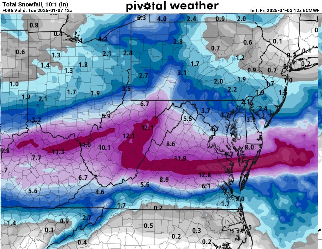
I think parts of southern KY may bust a bit on expected wintry QPF totals from the weekend storm but overall, I say we're dodging an icy bullet. Sharp ice/snow accumulation cutoffs into central KY seem likely but we'll see. Really hoping this system plays a healthy part in setting the table for us mid-month. My current concern is the Sunday/Monday system being a miss to our north and the following system a miss to our south.
-
1
-
-
1 hour ago, Carvers Gap said:
We haven't just lost the deterministic Euro. We have lost the EPS top to bottom. It has thrown out some really strange runs of late(just every once in a while after being rock steady for more runs than I can count). Temp wise, it has lost a good chunk of the cold as well - entire run. I think what is going on right now is that modeling is struggling with very cold temps coming into NA along with a complex storm pattern. Right now, I don't trust any of them. However, the 12z GEFS and GEPS seem to be pretty steady without any breaks in continuity. For now...for now...I ride with those two and toss the EPS. Operational Euro is probably good through d6 or d7. I would suspect ice to rain for Sunday....but I don't trust any model right now. Ride with the ensembles until things settle down a bit. We generally go through wild swings when cold air is in play. Also, when do models lose storms? Yep, bout right now.
Yeah, this isn’t a Lucy with the football situation. It’s probably more the models rubbing their eyes, second guessing data validity.
-
1
-
-
-
11 hours ago, John1122 said:
I don't even know what folks in the deep south would do. That would be a record for many of them. 1993 levels.
Shades of 2013-14 for portions of middle TN on that run. Snowdome 2.0...especially for NW middle TN.
 Hopefully, the suppression won't be THAT strong but like Carver said, the fact it's possible is proof of the potential in play.
-
1
-


1/10-1/12 Southern Slider
in Tennessee Valley
Posted
I had the same initial reaction with respect to Nashville. Not sure how they're deriving this...