

*Flash*
-
Posts
762 -
Joined
-
Last visited
Content Type
Profiles
Blogs
Forums
American Weather
Media Demo
Store
Gallery
Posts posted by *Flash*
-
-
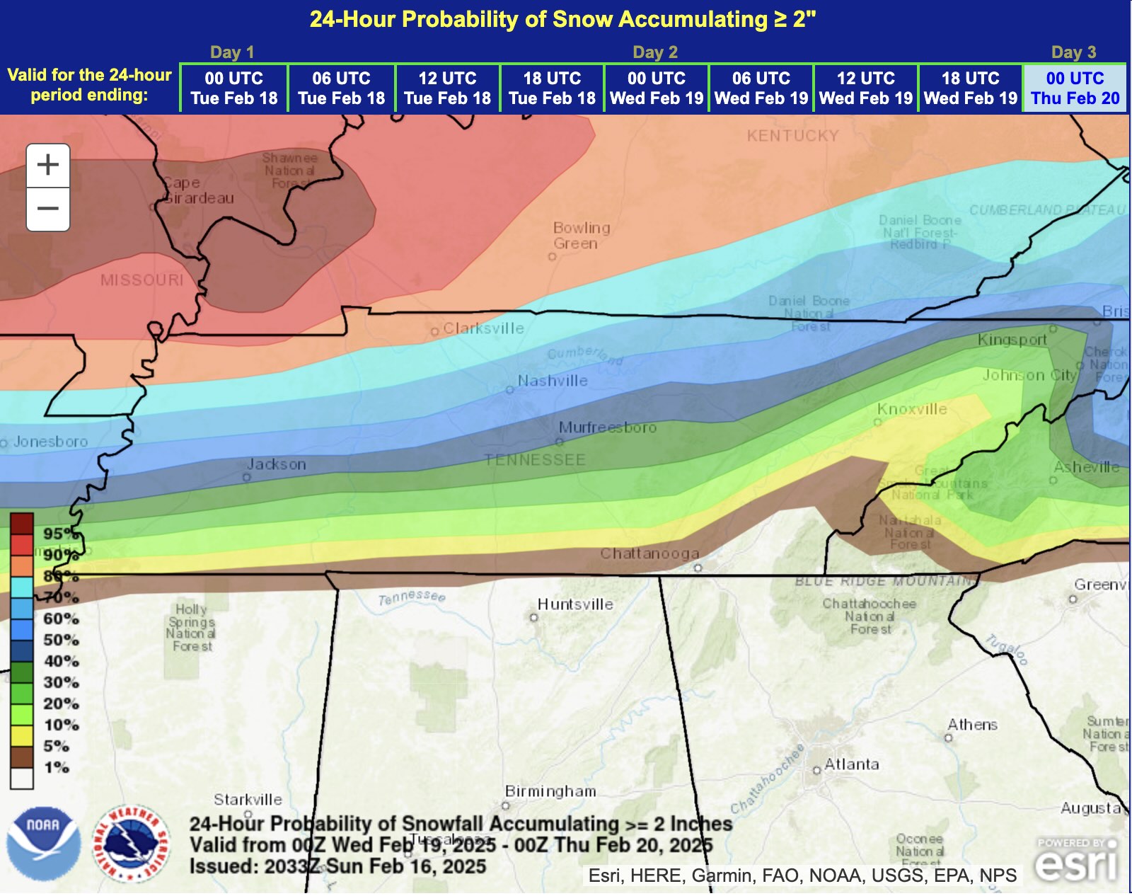
WPC FWIW. Notable gradient over I-40 so I'd say it's legit...


-
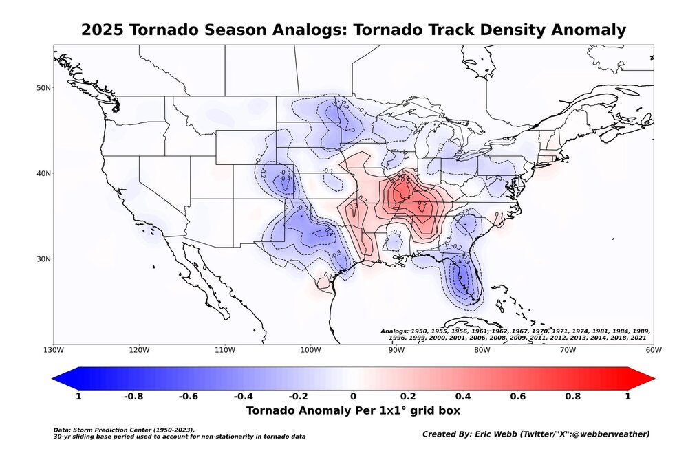
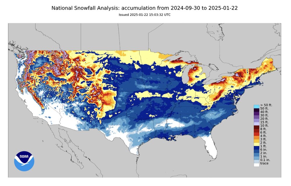
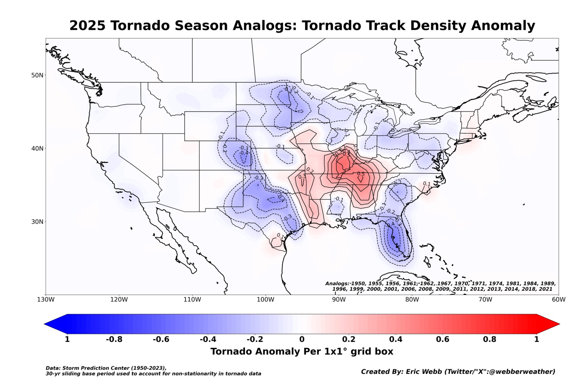
I thought these were interesting. Note Nashville proper is one of the hot spots.
-
 1
1
-
-
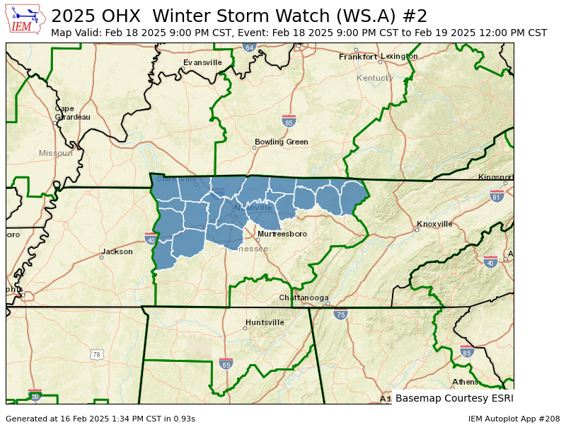
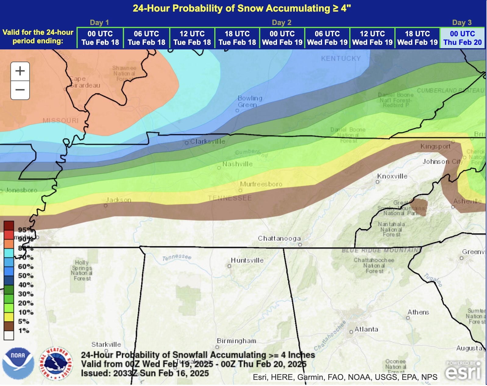
Man, OHX got their Winter Storm Watch out earlier than usual! Gotta think confidence is increasing...
URGENT - WINTER WEATHER MESSAGE
National Weather Service Nashville TN
134 PM CST Sun Feb 16 2025

TNZ005>011-023>031-033-034-056-057-059-170345-
/O.NEW.KOHX.WS.A.0002.250219T0300Z-250219T1800Z/
Stewart-Montgomery-Robertson-Sumner-Macon-Clay-Pickett-Houston-
Humphreys-Dickson-Cheatham-Davidson-Wilson-Trousdale-Smith-
Jackson-Overton-Fentress-Perry-Hickman-Williamson-
Including the cities of Lobelville, Dover, Ashland City,
Livingston, New Johnsonville, Lafayette, Mount Juliet,
Gainesboro, Celina, McEwen, Hartsville, South Carthage,
Nashville, Jamestown, Lebanon, Dickson, Kingston Springs,
Tennessee Ridge, Brentwood, Erin, Waverly, Carthage, Gallatin,
Centerville, Springfield, Gordonsville, Hendersonville,
Goodlettsville, Franklin, Byrdstown, Linden, Clarksville, and
Allardt
134 PM CST Sun Feb 16 2025

...WINTER STORM WATCH IN EFFECT FROM TUESDAY EVENING THROUGH WEDNESDAY MORNING...

* WHAT...Heavy snow possible. Total snow accumulations between 2 and 5 inches possible.
* WHERE...A portion of Middle Tennessee.
* WHEN...From Tuesday evening through Wednesday morning.
* IMPACTS...Plan on slippery road conditions. The hazardous conditions could impact the Wednesday morning commute.

PRECAUTIONARY/PREPAREDNESS ACTIONS...

Monitor the latest forecasts for updates on this situation.
-
 4
4
-
-
I don't hate my location with the midweek system. Just sucks to see another case of weakening energy ahead of the transfer. Seems like our area is ideal for losing juice. This is a primary reason why our 4-6+" last month turned into a 3-5" situation.
-
1 hour ago, John1122 said:
This EPS run may be as good as any we see for this system. Add an inch for ratio's north of 40 especially.
I'm rooting for this, not only because it's a great forum-wide look but because our NC friends can have a nice score as well!
-
2
-
 1
1
-
-
30 minutes ago, jaxjagman said:
Each run now seems to be creeping up to the typical 1-40 battle zone,next few model runs it wouldnt surprise me if its all rain and not snow here
I don't disagree, though I'm fairly confident a decent chunk of our viewing area will experience a wintry mess, at the very least the NW quadrant of the midstate.
-
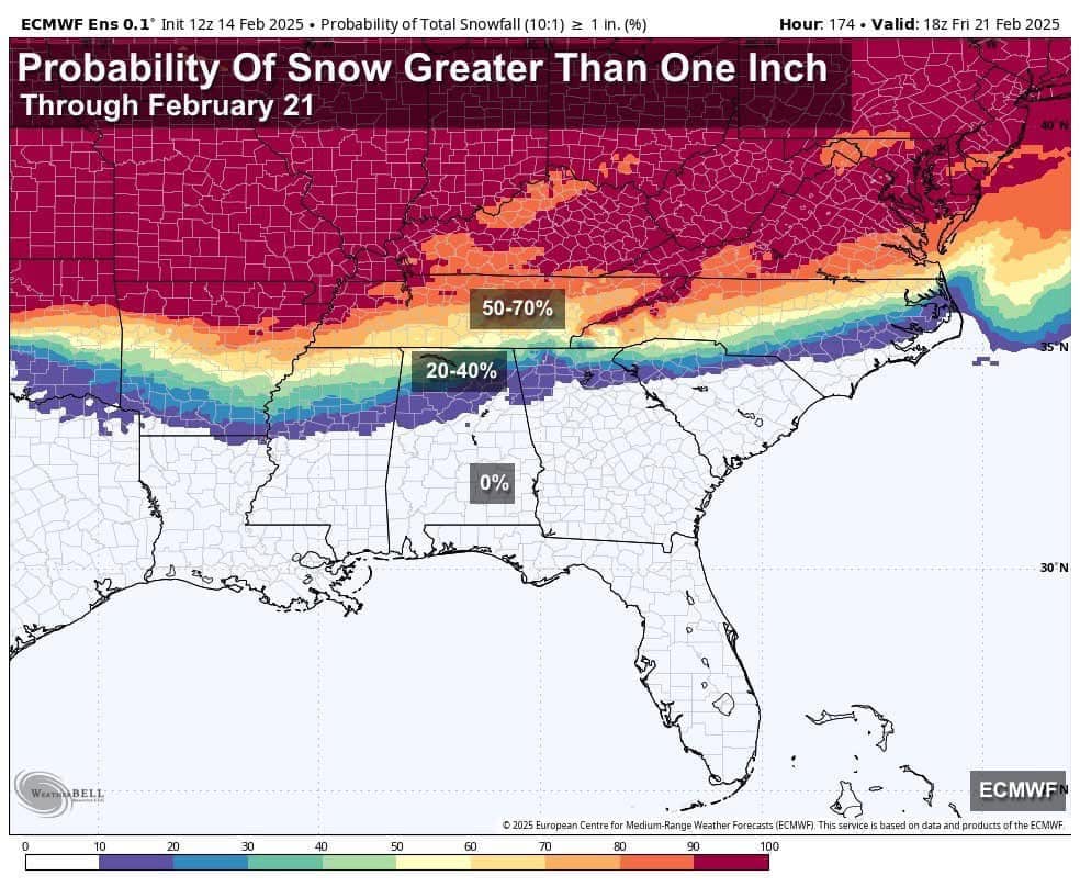
Nice to see likely probs (along and north of 40) from the EPS this far out...

-
2
-
1
-
-
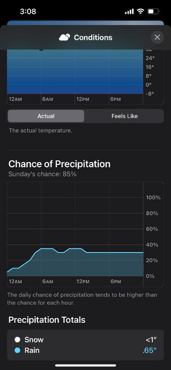
Currently 43 and very light rain/ice pellets against a relative humidity of 48%. Another night on which I wish I could be just 100 miles north.

-
2
-
1
-
 1
1
-
-
10 hours ago, Daniel Boone said:
This could turn out to be a heartbreaker next week if the Blocking isn't strong enough. We could see heavy Snow just to our North and to the East. Today's guidance continues to waffle but seems to want to hone in on the area across Ky into Wv and across Central Va. Hopefully the further South Track is realized.
It's still a Week away so, plenty of time.
My gut says prepare for heartbreak as we’re too far south in the battleground setup BUT like last month, this first system may set the table for the next.
-
1
-
-
18 minutes ago, 1234snow said:
I will reiterate what John said a few days ago. The February Firehose is getting turned on. Will it be wet, white, or frozen?
Or (a wintry mix of) all of the above. Usually that selection on a multiple choice test is the correct one.
-
4
-
-
3 hours ago, John1122 said:
We are on the edge of glory or heartbreak. We either watch the Ohio river get buried while we get soaked, or we get waves of winter weather. Models aren't quite sure yet just how much se ridge we get.
Not every day I’m reminded of Lady Gaga on the forum.
-
 2
2
-
-
Bam Wx posted an update vid today validating much of what Carver has been saying in recent days. I learned while MJO Phase 4 and 6 are crapshoots for the TN Valley, sometimes the OH Valley can squeeze out a surprise in Phase 5. Not as blowtorch-y in that phase. We'll see what can happen as we rotate through. Still optimistic for late February/early March.
-
2
-
-
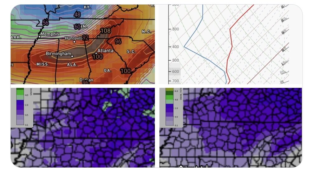
6 hours ago, Holston_River_Rambler said:
Bored this PM so I thought I'd try my hand at a snow map

I'd take a few snow showers just for the wintry vibes but I'm probably too far west for even that. Like you, I'm so freakin' bored right now, I'm refreshing my wet bulb calculator every 15 minutes. Go Bills!!!
-
1
-
-
On this day 25 years ago, the Carolina Crusher struck putting down 2’ along an unusual corridor east of the Apps and generally west of 95 up through northern VA. Didn’t realize until today the busted forecast led to the creation of WPC!
-
4
-
-
2 hours ago, John1122 said:
The AI is toasty, some of us may make a run at 80 in the southern areas of the forum per some of it's runs.
Also happened in February 1996.
")
-
 1
1
-
-
Certified wild, ya'll. For our areas, I'd say this winter is on pace for 'Could have been better, could have been worse' territory. We'll see how February/March fills this in...
-
2
-
2
-
-
On a separate note, really happy for my friends down in Mobile/South Alabama. Random anecdote...but for one glorious year, I was a met major at USA. Late 2000’s roughly. Loved the program but ultimately went a different direction as it became clear the occupation would have consumed me entirely. Pretty hard decision back then but made a lot of great friends and let me tell ya, getting an excused absence to go stormchase, doesn’t get much better than that.
-
7
-
-
31 minutes ago, John1122 said:
Looks like a cool/cold rain for us.
Yeah, probably right. Winter ain’t over though. That’s for darn sure.
-
Sooo…anyone want to talk about Sunday/Monday? What the Euro AI is seeing? Could just be cold chasing moisture but it seems like the sniffing out period has begun.
-
3
-
-
Thank you, Carver, for redirecting focus to the future. Certainly helps on days like today.
-
3
-
1
-
-
For kicks and giggles. App thinks it’s going to snow here late next Sunday and Monday.

-
4
-
-
Took half the kiddos to Cookeville. About an inch but it went a long way. Wasn't too wet and had plenty of crunch. Roadways, primary and secondary, were fantastic so it was a great day to get out. Probably a quarter inch back in the Bluff as we left around 9 am but it's all gone now except shady areas.
-
4
-
-
More fun from Bobby: “4 pm Update 1/18 for Middle Tennessee winter Weather later tonight and Sunday morning.
We get into the left exit region of that 100 kt speed max in the overnight hours tonight into Sunday morning. The latest forecast soundings have found more moisture than previous runs. I now think 1/2 inch with up to 1 inch looks possible in the Nashville area. 1 inch along the plateau but upwards of 2 possible in the Upper Cumberland. That 10 model blend looks good to me for amounts through 6 pm Sunday. CAMS blend is also good. Freezing almost down to Kuttawa Kentucky at 3 pm 1/18. I'll do another update this evening.”
-
5
-
-
Health pending, I’ll likely be in Monterey tomorrow so I’ll follow up with some ground truth this time tomorrow.
-
2
-


2/19-2/20 Miller A Magic?
in Tennessee Valley
Posted
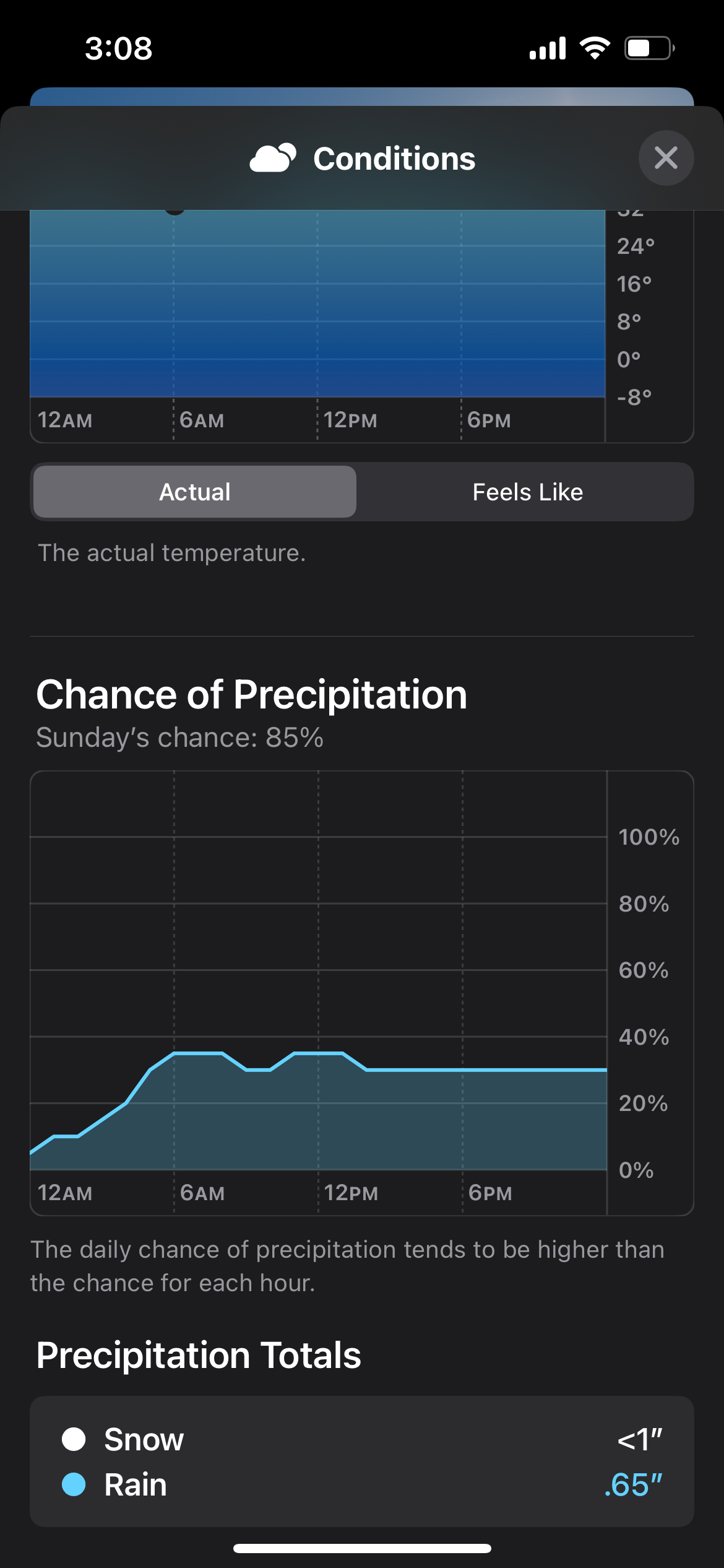
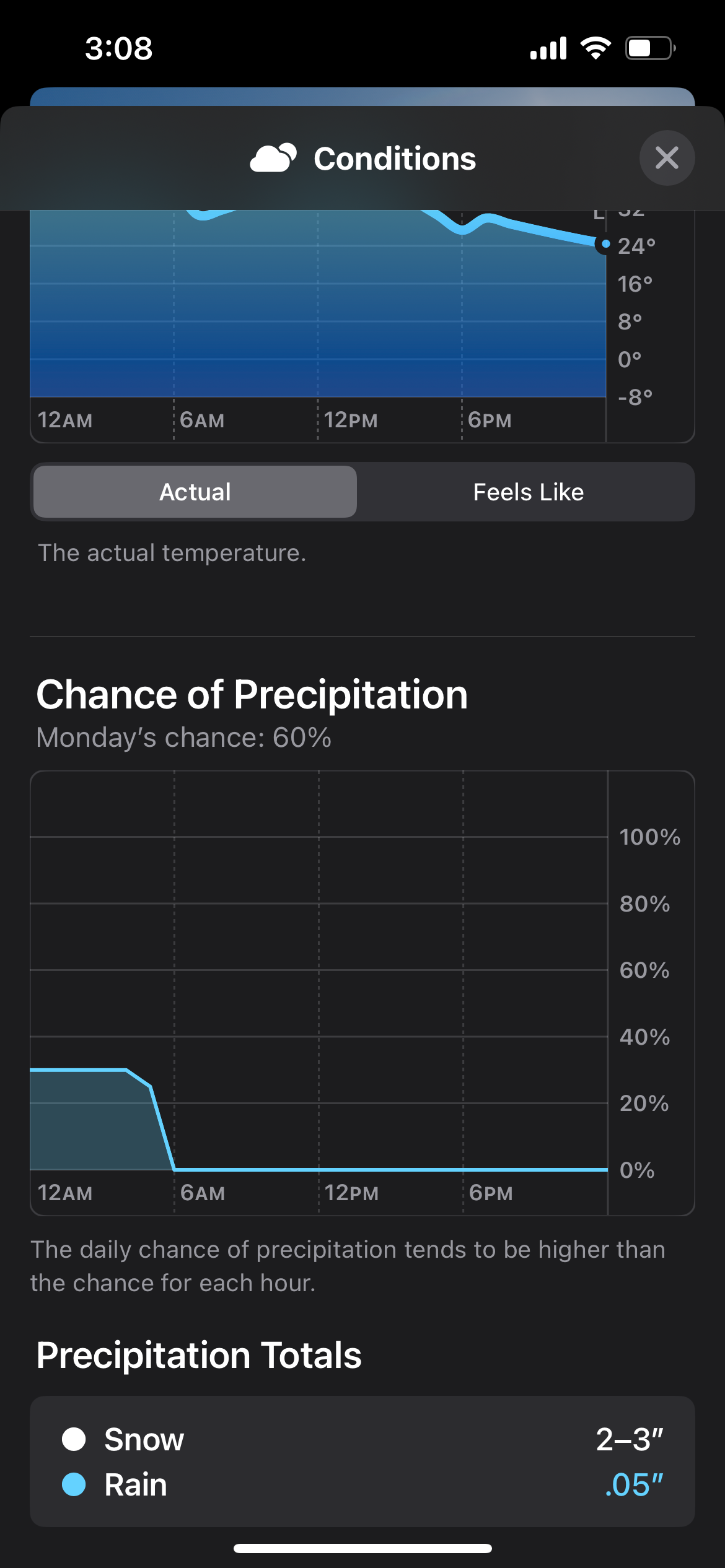
Finally, % of at least 1". Sorry, Polk County...