

*Flash*
-
Posts
602 -
Joined
-
Last visited
Content Type
Profiles
Blogs
Forums
American Weather
Media Demo
Store
Gallery
Posts posted by *Flash*
-
-
2 minutes ago, kayman said:
This is the same supercell that Paducah NWS Forecast Office had observed with a funnel cloud over an hour ago.
Yep. I don't know what it is about this part of Kentucky as it has seen its share of long-track, violent tornadoes in recent years.
-
 1
1
-
-
Crazy to watch what's going on in west/central KY tonight. Definitely an outbreak on our hands though it seems down in TN, we'll have more CIN/weaker lift to mitigate the threat.
-
A short time lapse of the Columbia tornado I intercepted earlier today. I positioned myself a few miles south of the track...
-
 4
4
-
 3
3
-
-
For posterity...
-
4
-
-
3 hours ago, PowellVolz said:
April 1st and 2nd has an interesting look to it. Mid South, Ohio Valley region
.SPC states the predictability is too low at this point. We shall see what happens.
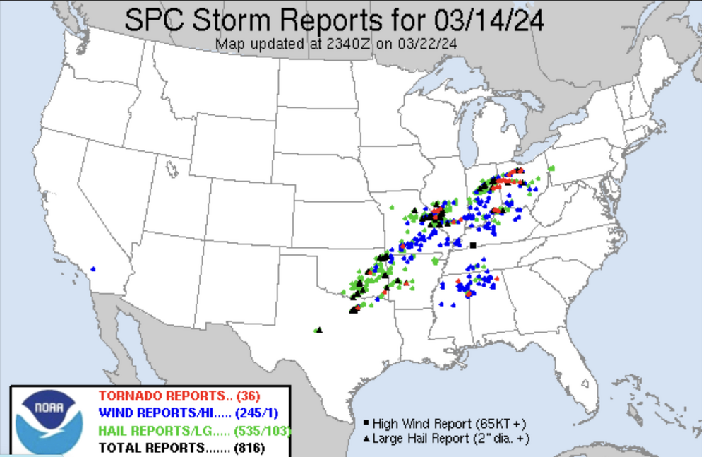
On a separate note, if you would have asked me one month ago March would finish 4-5° above normal with only a handful of statewide reports (3/14/24 was our only semi-active day), I would have cited nonsense. A remarkably quiet month!
-
5
-
-
On 3/14/2024 at 8:08 AM, *Flash* said:
Yeah, I knocked on wood with that post. Slight and marginal risks expanded eastward overnight. I’m not worried though, at least right now. If that slight risk encroaches into western middle, my antennas will elevate. How about those TVA’s in Kansas last night? Some textbook material for sure…
Speak of the devil. They did it again. Another eastward shift!
-
On 3/14/2024 at 12:20 AM, jaxjagman said:
I dont know.Some of the short range models are coming in quicker tomorrow,wouldn't surprise me if a slight risk was introduced further east next update close to Nashville
Yeah, I knocked on wood with that post. Slight and marginal risks expanded eastward overnight. I’m not worried though, at least right now. If that slight risk encroaches into western middle, my antennas will elevate.
-
Bam Wx put out an informative long term forecast yesterday. He suspects the rapid ENSO evolution could result in a stormy April. Things look relatively tame and seasonal for most of our viewing areas until then. Of course, the same can’t be said for areas west and northwest of our state.
-
DT has been down for the past month since the consensus Feb forecast busted (understandable given his locale). His X account has been an exhibition to his spiral of late.
On a separate note, I was reminded of a localized 3” snow event that took place 3/11/17 in western middle TN in the heels of a blowtorch January/February. As much as I want one last Hail Mary pass, the gut feeling is the refs are on the sidelines about to call the game. No more time on the clock for this winter though maybe for 2500’+?
-
1
-
-
4 hours ago, Daniel Boone said:
Yeah. Also remember 2008 a very warm March that transferred to a very cold early April with heavy Snow Shower's the 8th. March 07 was mild to then a hard late Freeze occured in mid May that killed alot of the Leaves on the Tree's. Likewise, after the very mild Winter of 01-02 late Season Freezes occurred on the 22nd and 23rd of May with Temps recorded in the upper 20's. Needless to say, foliage and vegetation damage occured.
March 2007 was very warm, akin to 2012. A year later in 2008, we had a notable snow event March 7-8. About half a foot in my current locale! One of those winters saved by the bell at the last window of opportunity.
-
1
-
-
10 hours ago, Carvers Gap said:
Still a ways out there, but a pretty significant pattern change is now on d14-16 of global ensembles (not just LR ext models). To be fair, this is where it got last time, and it flipped warm. So, just that caveat. Overall though, that is a pretty cold look. I doubt that means measurable snow for many of us, but wouldn't surprise me to see some late season frozen precip in the air and maybe a dusting. Higher elevations have a legit chance at late season mischief if that is correct - anything above 2500'.
Here’s rootin’ for some wintry mischief in Monterey later this month. Just need one more snow in the air moment and I’ll be good ‘til next winter.
-
3
-
-
Jet stream and better dynamics to our northwest. Not going to complain.
")
-
2
-
-
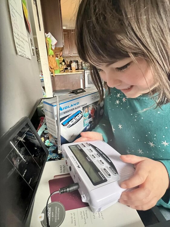
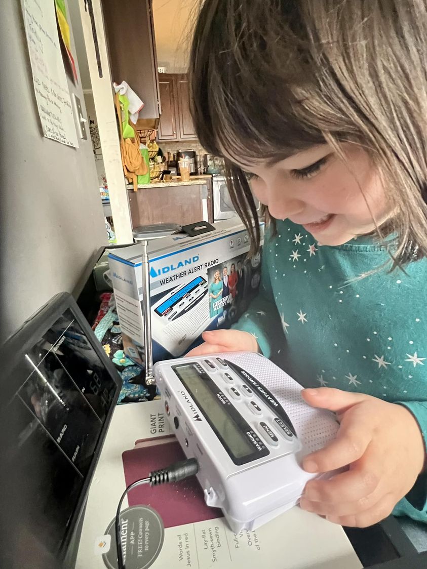
I brought home a new NOAA weather radio yesterday much to the joy of my now 6-year-old daughter, Evy, who has a legit storm phobia. Also picked up James Spann's Benny and Chipper book. After the 12/9/23 event*, we're going into the next season fully prepared, lol.
*I kid you not: She was so impacted by the tornadoes that day, she told me just last week the date the last tornado in our county hit (I.e. 12/9/23). Apparently, she was listening in the backseat when I was livestreaming damage reports the following day.
-
4
-
2
-
-
A quick minute from SWAD 2024. James is right. More TV mets should consider being more familiar with specific landmarks and reference points when doing storm coverage.
-
2
-
-
If the Euro Weeklies are going warm, I'm going to expect a cold snap. I believe in Murphy's capacity to thwart and troll spring breaks in our region.
-
3
-
-
14 minutes ago, BNAwx said:
I wonder if the model mayhem this winter has been due to the constant pressure the strat PV has been under for what seems like the entirety of the winter season. This year just seemed anomalous to me in that regard but maybe it’s not as unusual as I think it’s been.
One thing about this hobby is just when you think you’ve got a decent understanding of how everything “should” work, Mother Nature throws you a Mariano Rivera cutter….
I can appreciate this reference. Rivera's career ERA (2.21) will soon be the average snow total for most of our respective locales.
P.S. It's a shame he never won a Cy Young. He deserved it in 2005.
-
2
-
-
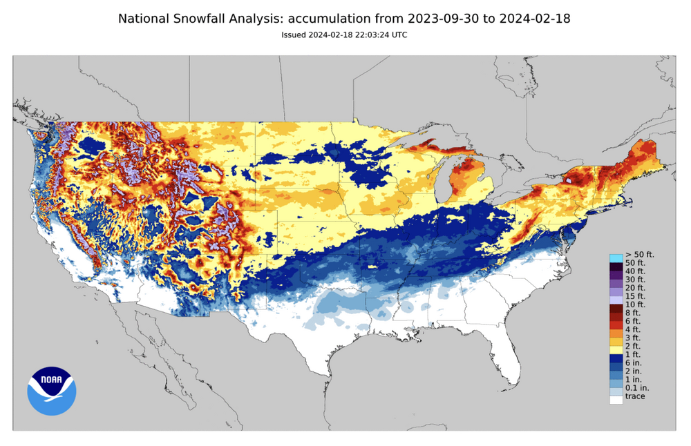
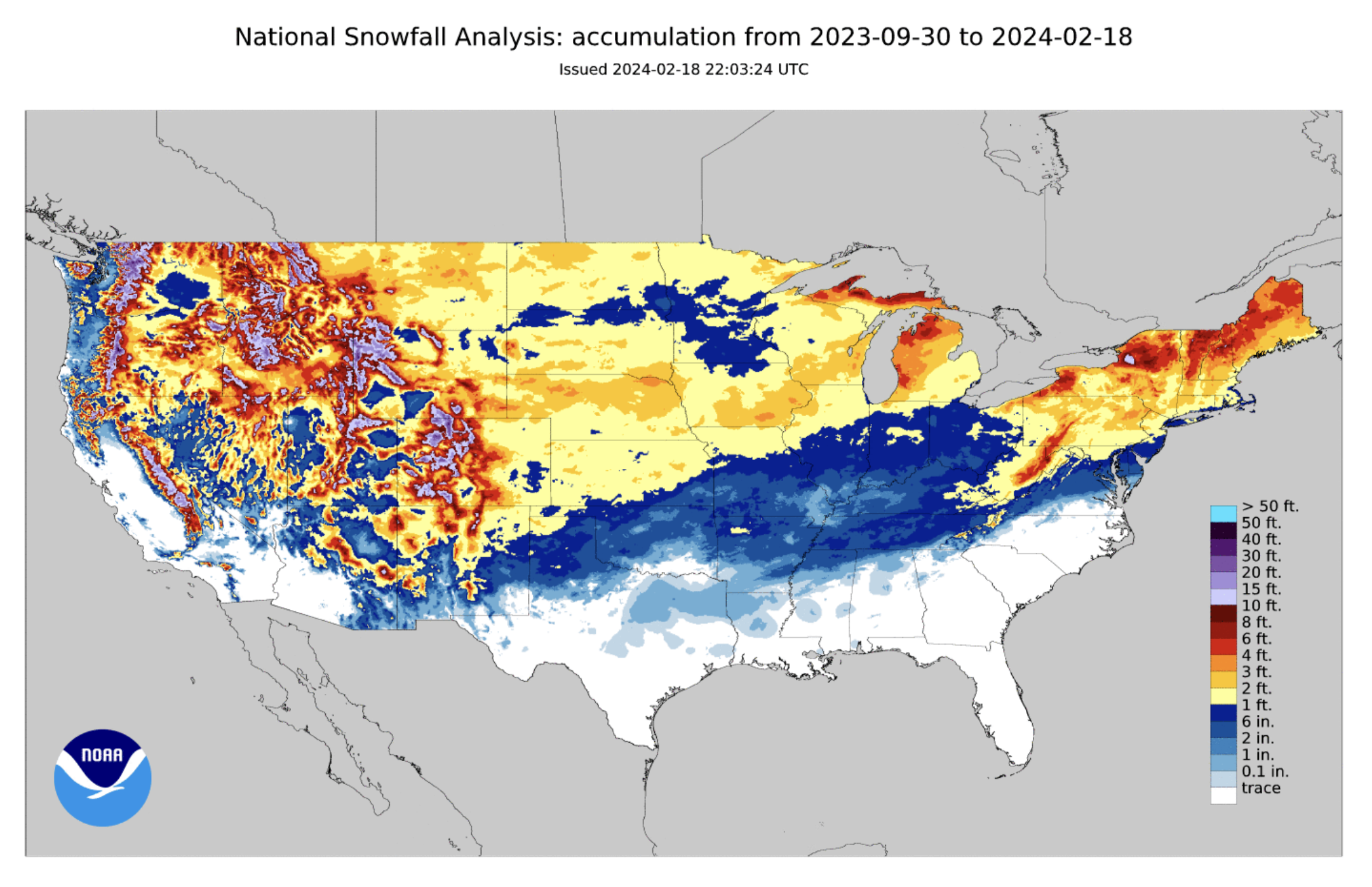
Season snowfall to date. I imagine our part of the world won't see much adjustment on the 2023-24 seasonal snowfall maps. Easily could have been worse when you consider locations to our immediate northwest and, of course, the southern mid-Atlantic down through the Carolinas. The blues in Minnesota are also telling.
-
1
-
-
22 hours ago, Carvers Gap said:
I think that has merit. My guess would be western North America and then maybe it slides eastward. There are still some big cold fronts showing up on the GFS. Usually when winter is over, you don't see those cold fronts on LR modeling. OTH, it may just be cold and rainy. The Euro weeklies have hinted at a second-week cold shot. There is definitely some warm weather in between those cold shots though.
I concur with both you guys. I tend to think if a cold shot verifies, it will be too late for the valleys. Kinda in that awkward in-between phase where severe talk makes more sense for the majority but winter is still on the board for elevations partially immune to climo. While it would be great to have one more system to track, I agree with you Carver and others who have hinted at this winter clinching a passing grade depending on here you live. Had anyone told me on 12/1/23 my backyard would see 9" of snow for the winter (above average by 1981-2010 and 1991-2020 standards), I would have taken that and run. Quantity-wise, I prefer winters that produce a trackable winter storm per month on average, granted beggars can't be choosers. Sure seems to me that March is trending more towards lion than lamb. As long as the pattern doesn't become too dry and benign, I'll take it.
-
3
-
-
A short and sweet time lapse for a short and sweet snow event during which it practically rained snow.
-
4
-
1
-
-
7 hours ago, jaxjagman said:
That was a nice little storm,some intense snow with flakes over a half dollar and thundersnow,to bad it's already about to end
Yeah, it was fun while it lasted. Wish I could have heard that thundersnow given it occurred on the west side of town.
-
1
-
-
Still snowing. Almost to an inch now. Super low ratios.
-
4
-
-
3 minutes ago, BNAwx said:
What’s your current temp?
36. I don't imagine this will last long but we've secured a decent coating under some pretty strong returns. This is the wettest, slushiest snow I can remember. Instantly melts on exposed skin and funnels down fast. If you ever wanted to take a shower in snow, this is your best bet.
-
5
-
-
Pouring snow in White Bluff. Silver dollar sized flakes. About a half inch on the ground in only 15 minutes.
-
5
-
-
Middle TN just got NAM'd. The crazy trends continue. Gotta think there will be some northerly corrections and amounts potentially lower due to wet ratios. Timing will be key should this system speed up. Right now, it sure looks like this will be a nocturnal event.
-
2
-


Tn Valley Severe Weather
in Tennessee Valley
Posted
Right now, SPC has a Marginal Risk for west/middle TN. As BB tweeted earlier, if we can get some instability tomorrow, the kinematics are there. One must wonder if this is a sleeper threat that should be upgraded to a Slight Risk sooner rather than later?