
Poimen
-
Posts
2,147 -
Joined
-
Last visited
Content Type
Profiles
Blogs
Forums
American Weather
Media Demo
Store
Gallery
Posts posted by Poimen
-
-
Just now, PackGrad05 said:
Meteorology is different than modelology. Models can say one thing, but looking at the actual pattern and understanding what can actually happen is why meteorologists have their job.
Surface temps as well as temperatures aloft have been suspect to me for RDU the entire week. A clown map should be used to see where the heaviest snow will fall, while ignoring amounts.
To me, central NC may see some snow, but will mostly be a cold rain with maybe some sleet pellets mixed in at times. I would be SHOCKED for anyone in Wake to see more than 1 inch of snow on the ground, and you may want to snap a photo of it if it happens because the rain after will wash it away.
You are right...but what you're not understanding is that the models have been cooling the atmosphere from the top down as the precip and lift moves in. Perhaps the better discussion is if that scenario is plausible/likely.
-
 1
1
-
-
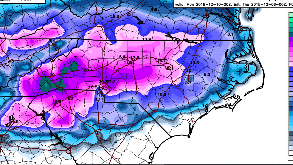
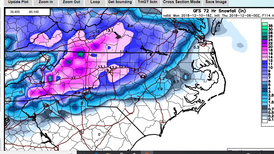
This is going to be a really big test for the FV 3. I'm curious to see how accurate it is. It has not wobbled one bit that I can recall in recent days. Going off the crude 4 panel NCEP maps, the 12Z looks like a good snow event for the western/northern Piedmont of NC. It also still has some leftovers on Monday.
-
3
-
-
3 minutes ago, TARHEELPROGRAMMER88 said:
GFS is warmer.
Dude...no offense but you're as predictable as the day is long. We are willing to concede that you are on record poo-pooing this entire event for everyone who is in it while you only dream of snow in Wilmington.
-
12
-
 2
2
-
 9
9
-
-
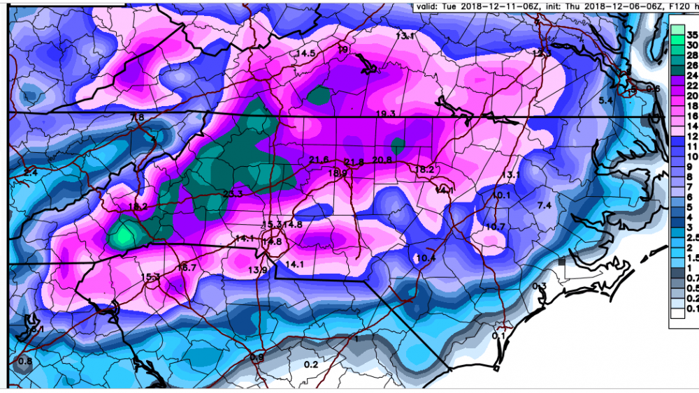
One last image from the Canadian, this is the deform band on Monday. Overall a really good run for folks along I85 north of Charlotte up to the Triad and parts of the Triangle.

-
-
Oh Canada:

-
5
-
-
The NAM just fired a warm nose warning shot,..as you all know. But I wonder since we're dealing with dynamical cooling if the NAM's lack of qpf played a role in that outcome? Will want to see how the NAM trends in these departments going forward.
-
1
-
-
12 minutes ago, Blue_Ridge_Escarpment said:
Precip type on 12Z looks suspicious. 850s cold enough in WNC for snow during entire event.
warm nose on the soundings was above 850.
-
3 minutes ago, WinstonSalemArlington said:
Tim Buckley: For those asking, the ground temperature in Greensboro is 41°. It will be a non-factor this weekend.
We had a nice hard freeze this morning here with a low of 23 and a heavy frost. Soil and sun are two non-issues for this event.
-
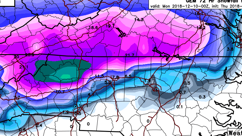
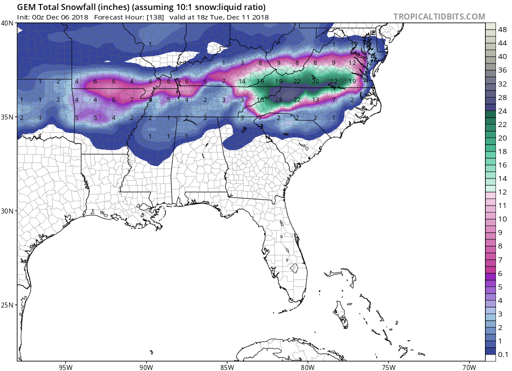
GEFS 6Z exceeds 2" qpf up to the Triad. It's good to see those beefy totals continue. It's crazy because normally we're talking about .25-.75 qpf. This one factor makes this event far different from most others in recent memory.
-
3
-
-
The FV3 is insane. It also has significant snows on the backside through late Monday.
-
4
-
-
One disturbing thing is that the GFS soundings are consistently showing less than full saturation in the snow growth region early Sunday morning, which coincides with the heaviest precip and coldest portion of the storm through the column. I'm not sure what to make of that, but I'd like to see full saturation up there.
-
1
-
 1
1
-
-
The 6Z Canadian is a snow beast for the I40-85 corridor from Asheville through the Triad. It looks like it has relatively narrow corridor of mixed frozen precip roughly from north of Charlotte to south of the Triad and then toward the Triangle. It seems that all of the guidance is converging on the arrival of precip in the NC piedmont to the pre-dawn hours Sunday, with the exception of the NAM.
-
1
-
-
-
Just now, Waiting on snow said:
I'm guessing that's not kuchera?
It's Kuchera, so I've been told.
-
1
-
-
FV-3 through 0Z Monday.
-
2
-
-
Looking at the FV 3 on the NCEP site and it looks like another big hit for much of central/western NC well into Mon., too.
-
2
-
-
Canadian Kuchera:
-
2
-
-
2 minutes ago, Brick Tamland said:
Canadian went south, eh?

No...but it finally got a clue on the cold/snow.
-
who would have ever thought that people in this sub forum would be flipping out for having their 24" clown maps downsized to 15"???
-
-
Based on the crude black and white maps, it looks like the Canadian is finally joining the party, too.
-
The 850s cool as the precip/lift moves in from the SW. All the models have been showing this. The atmosphere is literally cooling from the top down. Its impressive. I don't know that I've ever seen this modeled before.
-
1
-
-
NAM is now running on TT...BTW.


December 8-10, 2018 Winter Storm
in Southeastern States
Posted
It's the "GFS" on this site: http://mageval.ncep.noaa.gov/
It updates very quickly on the NCEP site but the site is not as user friendly.