
Poimen
-
Posts
2,147 -
Joined
-
Last visited
Content Type
Profiles
Blogs
Forums
American Weather
Media Demo
Store
Gallery
Posts posted by Poimen
-
-
1 minute ago, NCSNOW said:
ASK YOURSELVES THIS QUESTION: If the deck was flipped and the Nam was showing what all the Globals and ensembles where showing currently. Meaning they all where putting out end result of just ice/rain mainly because of out of sync HP/LP configuration, but the Nam was painting 12-20 inches in a large area. Would you be discarding the Nam and going with consensus?
Yes!
-
8 minutes ago, ryan1234 said:
So, I am curious about something. I've always noticed on some of our bigger storms that places like OK and AR seem to get snow as well. Sometimes extending to TN. Is what happens with their snowfall amounts worth noting and getting an idea for what we will receive? Like overperformance or snowfall farther south?
It can be helpful to look upstream and see how a system is performing in relation to the modeling. I don't know how much it matters in this case, though.
-
 1
1
-
-
One last frame from the Canadian for Monday morning:

-
 3
3
-
-
-
-
It looks like another solid run from the Canadian at 18Z. A good snow for the western/Northern Piedmont from about 6Z-18Z Sunday, followed by a transition to sleet/Freezing rain for some...then back to snow with a good deform band Monday.

-
 1
1
-
-
1 minute ago, PGAWx said:
To clarify - you mean there was more accumulation than the NAM modeled?
No---sorry if I worded that incorrectly. It's the oppsite. It was going bonkers with precip (1.5" qpf)/snow 24 hours ago and some areas are going to end up with zilch.
-
FWIW, and it may be totally unrelated, but it's interesting that it appears as if the NAM totally busted on the high side out in Oklahoma. Just brutal for some of those areas. Maybe it will bust here equally bad on the low side.
")
-
RAH did mention the possibility of snowfall totals near one foot in the Triad. So there's that.
-
1
-
-
RAH with the winter storm watch west of Raleigh.
-
overall a much better run for the NAM. Going forward I'd like to see if it can moisten the column sooner, allowing for more snow on the front end.
-
5
-
-
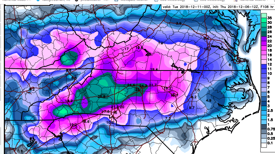
By 18Z Sunday the NAM has a sleet sounding over the Triad with a pronounced warm nose above 850.
-
The NAM has an incredible virga storm over the Piedmont Saturday night as it has a really dry air mass above the surface. The column finally saturates by 12Z Sunday in the Triad and the sounding is all snow.
-
1
-
-
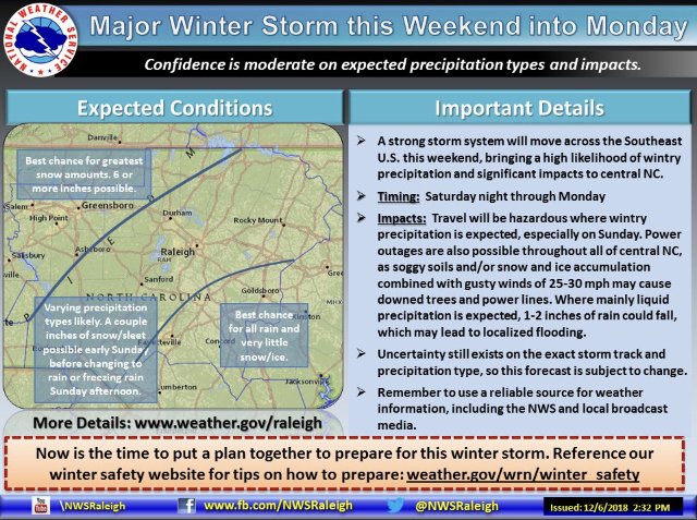
“Major Winter Storm”
-
1
-
-
3 minutes ago, tarheelwx said:
That tells me a lot of that isn’t falling as snow.
TW
yeah...the ARW cores had a mean snowfall of 11.63" though.
-
Does anyone care about the SREF plumes at this range? GSO snow mean is 8.3" and qpf is 1.56"
-
2
-
-
Just now, msuwx said:
FYI.....for those concerned about what wording the RAH NWS uses publicly, you can expect them to really beef up their wording this afternoon.
This sounds like inside info. Am I right?
-
3
-
-
Just now, griteater said:
Looks like the Euro is going to be similar to UKMet and FV3, the big 3
I suppose you can add the 12z Canadian to that list as well.
-
5 minutes ago, Cornsnow said:
I find that really hard to believe. Maybe take a 3rd or 4th of that and it might verify outside of the mountains, IMO.
I don't disagree. Still, will be interesting to see how it verifies.
-
As others have stated, this will be a big test for the FV 3.

-
3
-
-
14 minutes ago, wncsnow said:
Noticed that no one posted the UKMET.. anyone have some snow maps?
Here's the best I can do:

-
4
-
-
8 minutes ago, FallsLake said:
We need to pray this model is correct. .....we need to see the NAM come back on board.
which model are you referring to?
-
 1
1
-
-
-


December 8-10, 2018 Winter Storm
in Southeastern States
Posted
Yeah...If the precip can start earlier like the GFS, then that will up the snow totals considerably. Right now that might end up being the biggest hurdle. How long does it take to moisten the atmosphere? The GFS starts the precip a full six hours before the NAM and that 6 hours is all snow.