

Spartman
-
Posts
928 -
Joined
-
Last visited
Content Type
Profiles
Blogs
Forums
American Weather
Media Demo
Store
Gallery
Posts posted by Spartman
-
-
On 7/21/2022 at 11:33 PM, hawkeye_wx said:
Cedar Rapids hasn't hit 90º since July 5th. Our hottest days this week only hit 88º. We have one more chance on Saturday. The rest of the month currently looks <90º.
Not our year. We only hit 90 once this past Wednesday since July 5th. Only one heat wave this year, and that occurred last month. This weekend was supposed to be a heatwave, but failed to hit 90 each day including today thanks to getting screwed by debris clouds the past couple days. What a joke. Unless things get better again next month, I'm ready for Fall.
-
 2
2
-
-
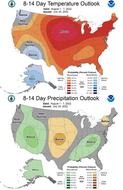
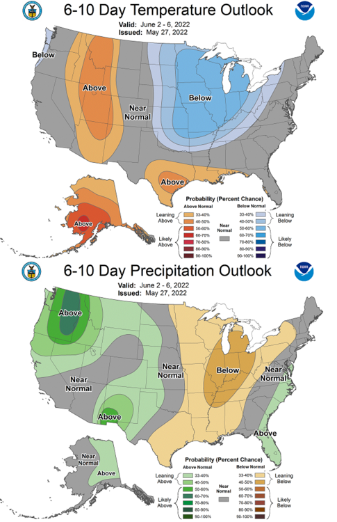
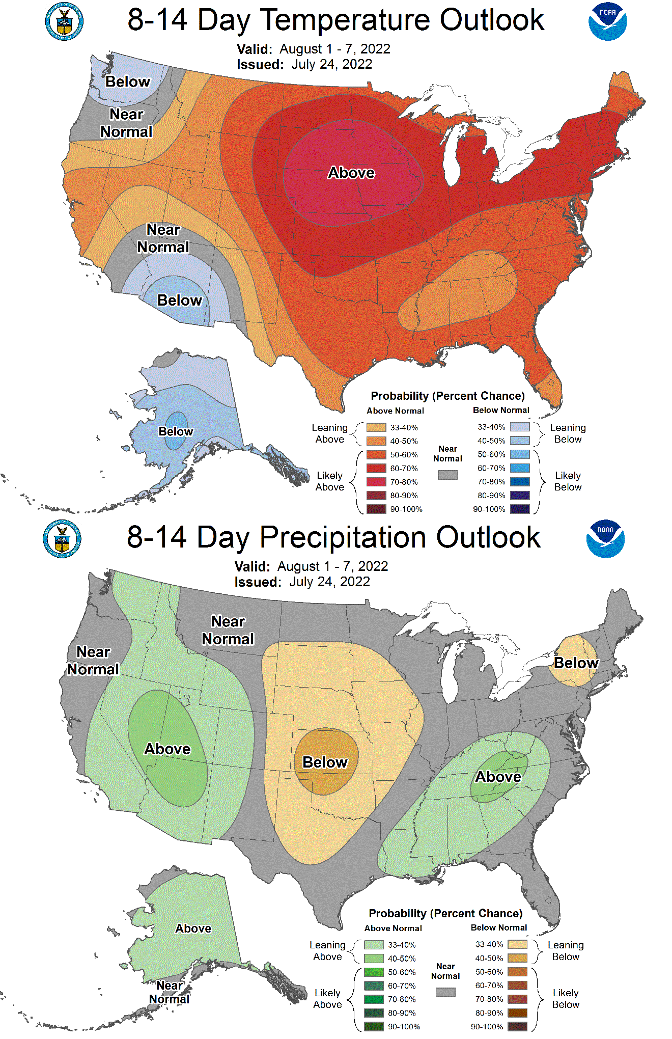
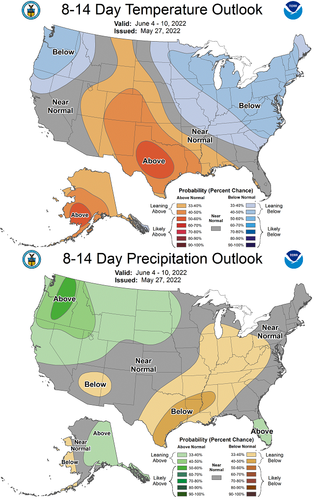
6-10 day:
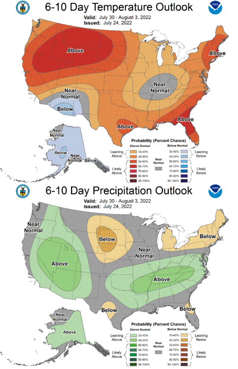
8-14 day:
-
Don't know what they're smoking, but NWS dropped forecast highs for today down to the mid to upper 80s while issuing a Heat Advisory for today.
-
000
SXUS71 KILN 180557
RERDAY

RECORD EVENT REPORT
NATIONAL WEATHER SERVICE WILMINGTON OH
157 AM EDT MON JUL 18 2022

...RECORD DAILY MAXIMUM RAINFALL SET AT DAYTON OH...

A RECORD RAINFALL OF 2.64 WAS SET AT DAYTON OH YESTERDAY.
THIS BREAKS THE OLD RECORD OF 1.48 SET IN 1948.


$$
Already just entered the 2nd half of July, and the rainfall total for this month is now 5.58". A bit early for an all-day washout. Columbus is already almost on its way to the top 10 wettest Julys.
-
33 minutes ago, hardypalmguy said:
Ended up with 1.12 inches here. At least the temp has warmed over 70 this afternoon. Was super concerned with how cold it was during the rain for mid July.
If only this was Winter.....
Already have 2.79" so far this month, though the majority of that was only during the 1st week of July. Are we just pushing for a record wet July at this rate?
Looks it'll be our turn later this weekend to experience what you're having today. Euro and GFS are apparently hinting the system to be Fall-like on Sunday with highs ranging from the upper 60s to the lower 70s. TWC has us down for a high of 75 on Sunday, JUST ONE degree above the record low maximum temperature set in 1925.
-
Only reached 75, completely overcast, 0.23" of rain. The dry periods today just seem to be boring and a waste for early July. A suckfest today.
-
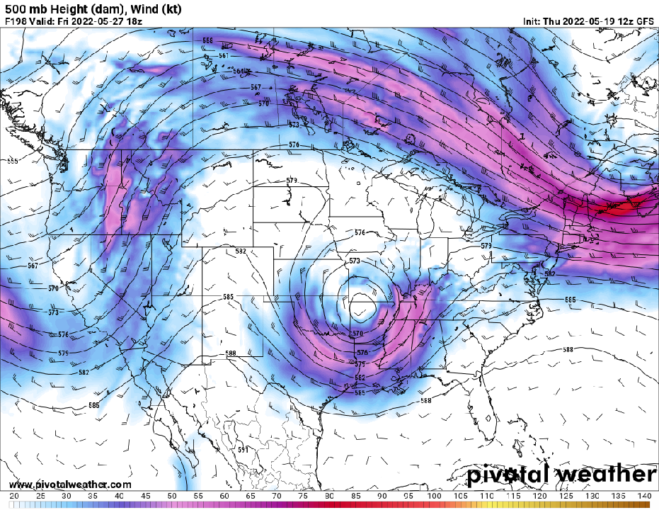
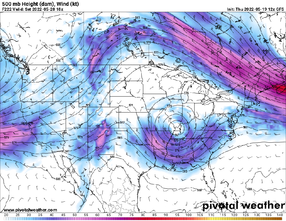
Certainly in for a Fall-like storm tomorrow. Could be the coolest day for this month.
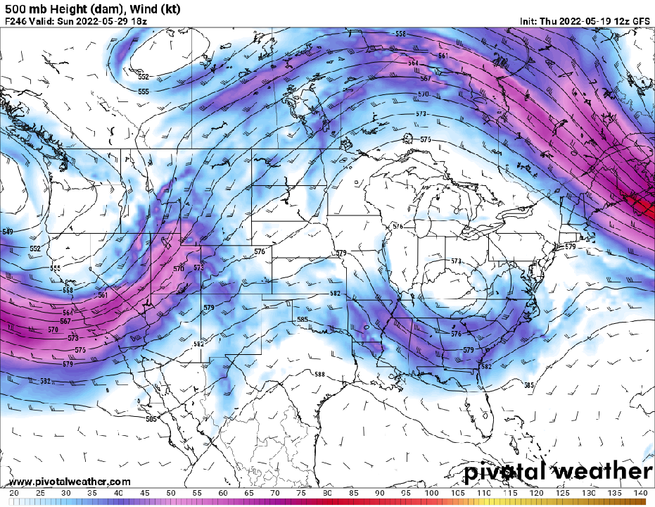
00z GFS: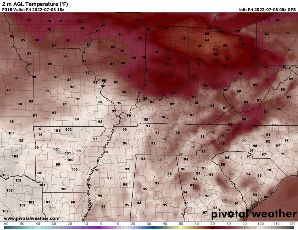
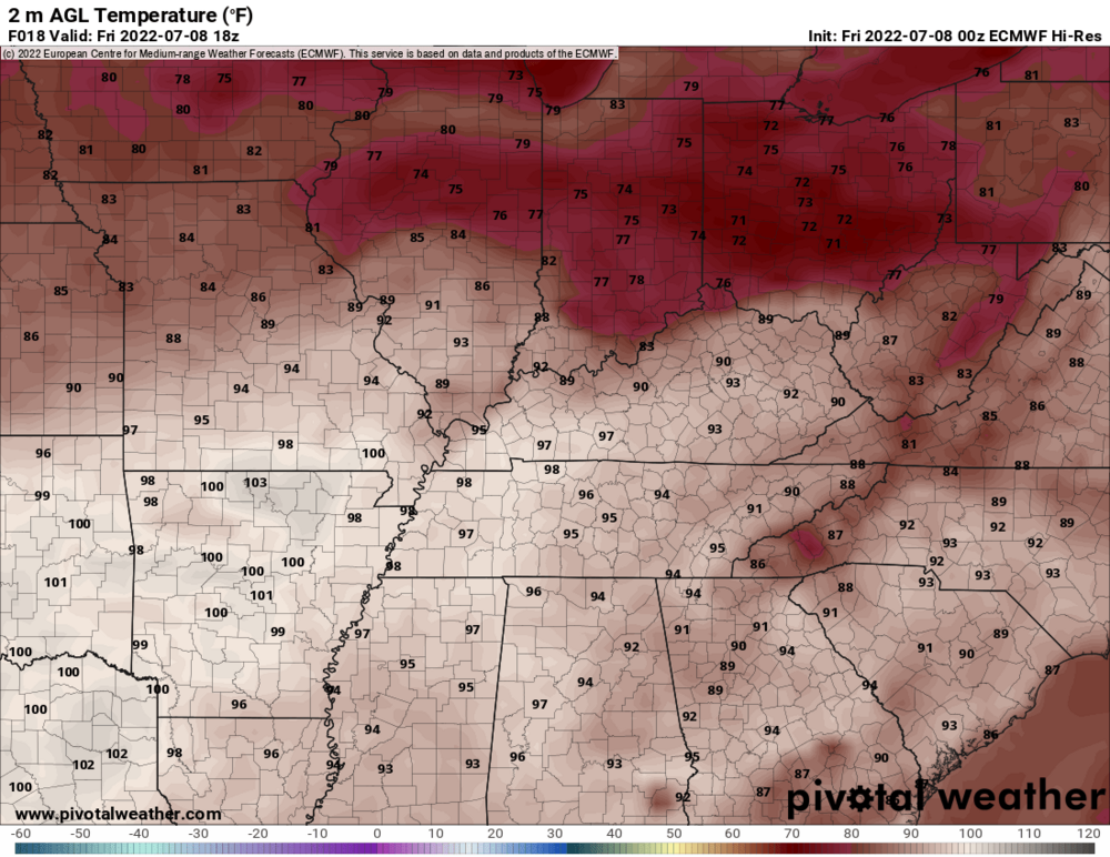
00z Euro:
00z NAM:

-
19 minutes ago, IWXwx said:
FWAland doing some drought busting
...ALLEN COUNTY...
FORT WAYNE 8.0 N             9.18 IN   0800 AM 07/06   41.19N/85.11W
3 E WALLEN                   8.85 IN   0850 AM 07/06   41.17N/85.11W
FORT WAYNE 6.0 N             8.58 IN   0645 AM 07/06   41.16N/85.13W
2 SSE ARI                    8.50 IN   0535 AM 07/06   41.24N/85.24W
FORT WAYNE 9.0 NNE           7.91 IN   0937 AM 07/06   41.19N/85.07W
WALLEN                       6.95 IN   0637 AM 07/06   41.16N/85.17W
ARCOLA                       6.40 IN   0648 AM 07/06   41.10N/85.29W
FORT WAYNE 4.1 NE            6.09 IN   0700 AM 07/06   41.12N/85.09W
FORT WAYNE 9.1 SE            5.82 IN   0700 AM 07/06   40.99N/85.00W
FORT WAYNE 1.6 S             5.62 IN   0800 AM 07/06   41.05N/85.14W
1 N LEO-CEDARVILLE           5.50 IN   0600 AM 07/06   41.23N/85.02W
FORT WAYNE 2.6 NE            5.40 IN   0700 AM 07/06   41.10N/85.11W
WOODBURN 2.6 NNW             5.31 IN   0900 AM 07/06   41.16N/84.88W
ELLISVILLE                   4.91 IN   0730 AM 07/06   41.02N/85.29W
FORT WAYNE 7.1 WSW           4.46 IN   0930 AM 07/06   41.05N/85.27W
FORT WAYNE 9.3 W             4.08 IN   0700 AM 07/06   41.05N/85.31W
WOODBURN                     4.05 IN   0430 AM 07/06   41.14N/84.86W
HOAGLAND 1.5 SSW             3.92 IN   0711 AM 07/06   40.93N/85.00W
MONROEVILLE                  3.68 IN   0700 AM 07/06   40.97N/84.86W
HARLAN 2.2 ENE               3.30 IN   0753 AM 07/06   41.20N/84.88W
HARLAN 3.4 NE                3.26 IN   0930 AM 07/06   41.23N/84.87W
FORT WAYNE 9.0 NNE           3.18 IN   0937 AM 07/06   41.19N/85.07W
FORT WAYNE 7.6 SE            3.00 IN   0700 AM 07/06   41.01N/85.02W
FORT WAYNE INTERNATIONAL AP  2.93 IN   0354 AM 07/06   40.98N/85.18W
FORT WAYNE 7.5 NNW           2.77 IN   0800 AM 07/06   41.17N/85.21W
If only this was Winter.....
-
 1
1
-
-
Heat wave cancel. Heat Advisory that was supposed to be in effect in the next hour has already been dropped.
-
-
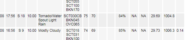
Even though DAY only got 0.15" of rain today, NWS confirmed a tornado sighting per their hourly observations.
-
21 hours ago, Hoosier said:
I found the ridging

Now we wait for Lucy and the football.
-
89'd after being stuck at 88 for several hours this afternoon. Highest we'll see for at least the next few weeks.
-
On 5/28/2022 at 3:30 PM, Spartman said:
TWC just posted a video about this yesterday. The Tonga eruption reached well into the ionosphere a.k.a. space.
https://weather.com/news/video/tonga-volcanic-eruption-biggest-explosion-ever-recorded-and-reached-spaceVEI-6 eruptions usually lead to noticeable short-term effects on the global climate. If this is the case, we can expect to see these effects during this Summer, just like in 1992.
JB already talking about a cooler-than-normal summer for much of the US. Wonder if this could be when we start to see the effects of the Tonga eruption that occurred in January. -
On 5/13/2022 at 4:59 AM, raindancewx said:
Tonga has been confirmed as a VEI 6 eruption, largest of the current century.
https://cosmosmagazine.com/earth/impact-2022-tonga-eruption/
Cooling in the 20S/175W vicinity was pretty massive for SSTs in month one. If you do 5/10 minus 1/10, the effect is still there. It will be interesting to see what happens as those waters should migrate about. I was going to look to see if winds were predominantly blowing from the NW to SE in the area of the volcano, but not quite sure what level to look at for the Sulfur movement. Ash made it 58 km up into the atmosphere.

TWC just posted a video about this yesterday. The Tonga eruption reached well into the ionosphere a.k.a. space.
https://weather.com/news/video/tonga-volcanic-eruption-biggest-explosion-ever-recorded-and-reached-space-
1
-
-
6-10 Day:
8-14 day:
-
12z GFS hinting a cutoff low for Memorial Day weekend.
-
1
-
-
000
CXUS51 KILN 010540
CF6DAY
PRELIMINARY LOCAL CLIMATOLOGICAL DATA (WS FORM: F-6)

                                          STATION:   DAYTON OH
                                          MONTH:     APRIL
                                          YEAR:      2022
                                          LATITUDE:   39 54 N
                                          LONGITUDE:  84 12 W

  TEMPERATURE IN F:       :PCPN:    SNOW:  WIND      :SUNSHINE: SKY     :PK WND
================================================================================
1   2   3   4   5  6A  6B    7    8   9   10  11  12  13   14  15   16   17  18
                                     12Z  AVG MX 2MIN
DY MAX MIN AVG DEP HDD CDD  WTR  SNW DPTH SPD SPD DIR MIN PSBL S-S WX    SPD DR
================================================================================

 1  41  31  36 -12  29   0 0.02  0.4    T 11.6 25 300   M    M   9 1      31 280
 2  51  26  39  -9  26   0 0.02  0.0    0  9.3 29 270   M    M   6        36 280
 3  55  37  46  -3  19   0 0.00  0.0    0  9.8 29 280   M    M   8        37 280
 4  61  38  50   1  15   0 0.12  0.0    0  9.5 18 210   M    M   7 1      23 220
 5  58  39  49  -1  16   0 0.09  0.0    0  6.5 16 130   M    M   9 12     19 140
 6  57  42  50   0  15   0 0.15  0.0    0  9.9 24 280   M    M   9 12     34 290
 7  53  38  46  -4  19   0 0.01  0.0    0 13.8 29 240   M    M   8        33 240
 8  49  37  43  -8  22   0 0.03  0.0    0 11.4 26 250   M    M   9 1      32 270
 9  43  34  39 -12  26   0 0.15  0.1    0 12.7 26 290   M    M  10 18     32 270
10  61  31  46  -6  19   0 0.00  0.0    0  8.9 18 140   M    M   6        22 140
11  66  50  58   6   7   0 0.30  0.0    0 14.8 31 230   M    M  10 1      39 220
12  70  49  60   8   5   0 0.13  0.0    0 10.1 20 170   M    M   7 1      23 180
13  68  61  65  12   0   0 1.15  0.0    0 12.7 23 170   M    M   9 13     35 160
14  62  40  51  -2  14   0 0.05  0.0    0 17.7 39 250   M    M   5 1      47 250
15  71  46  59   5   6   0 0.01  0.0    0 17.8 35 230   M    M   6        44 240
16  59  37  48  -6  17   0 0.10  0.0    0 13.5 32 230   M    M   6 1      40 240
17  50  29  40 -14  25   0 0.00  0.0    0  9.7 17  40   M    M   3        27  60
18  41  33  37 -18  28   0 0.31  2.3    T 12.9 25 300   M    M  10 1248   32 300
19  50  34  42 -13  23   0    T    T    0 13.3 26 290   M    M   8        32 290
20  62  32  47  -9  18   0 0.00  0.0    0 11.5 22 130   M    M   7        29 130
21  68  53  61   5   4   0 0.26  0.0    0 12.9 33 220   M    M   8 18     46 230
22  75  46  61   5   4   0 0.00  0.0    0  7.9 16 140   M    M   7 12     20 170
23  84  53  69  12   0   4 0.00  0.0    0 11.2 23 210   M    M   3        28 210
24  82  66  74  17   0   9 0.00  0.0    0 14.6 25 220   M    M   6        35 210
25  74  48  61   4   4   0 0.16  0.0    0 10.3 24 250   M    M   8 1      31 220
26  51  37  44 -14  21   0 0.00  0.0    0 12.3 23 310   M    M   6        27 310
27  57  33  45 -13  20   0 0.00  0.0    0  9.7 21 320   M    M   2        26 300
28  57  39  48 -10  17   0    T  0.0    0  8.8 17  70   M    M   9        22  50
29  66  48  57  -2   8   0 0.00  0.0    0 11.2 17 120   M    M  10        20 110
30  67  50  59   0   6   0 0.11  0.0    0 14.0 23 130   M    M  10 3      30 130
================================================================================
SM 1809 1237       433  13  3.17  2.8    350.3          M      221
================================================================================
AV 60.3 41.2                              11.7 FASTST   M    M   7    MAX(MPH)
                                 MISC ---->    39 250                 47 250
================================================================================
NOTES:
# LAST OF SEVERAL OCCURRENCES

COLUMN 17 PEAK WIND IN M.P.H.

PRELIMINARY LOCAL CLIMATOLOGICAL DATA (WS FORM: F-6) , PAGE 2

                                          STATION:   DAYTON OH
                                          MONTH:     APRIL
                                          YEAR:      2022
                                          LATITUDE:   39 54 N
                                          LONGITUDE:  84 12 W

[TEMPERATURE DATA]      [PRECIPITATION DATA]       SYMBOLS USED IN COLUMN 16

AVERAGE MONTHLY: 50.8   TOTAL FOR MONTH:   3.17    1 = FOG OR MIST
DPTR FM NORMAL:  -2.9   DPTR FM NORMAL:   -1.29    2 = FOG REDUCING VISIBILITY
HIGHEST:    84 ON 23    GRTST 24HR  1.20 ON 13-14      TO 1/4 MILE OR LESS
LOWEST:     26 ON  2                               3 = THUNDER
                        SNOW, ICE PELLETS, HAIL    4 = ICE PELLETS
                        TOTAL MONTH:   2.8 INCHES  5 = HAIL
                        GRTST 24HR   2.3 ON 18-18  6 = FREEZING RAIN OR DRIZZLE
                        GRTST DEPTH:  T            7 = DUSTSTORM OR SANDSTORM:
                                                       VSBY 1/2 MILE OR LESS
                                                   8 = SMOKE OR HAZE
[NO. OF DAYS WITH]      [WEATHER - DAYS WITH]      9 = BLOWING SNOW
                                                   X = TORNADO
MAX 32 OR BELOW:   0    0.01 INCH OR MORE:  18
MAX 90 OR ABOVE:   0    0.10 INCH OR MORE:  11
MIN 32 OR BELOW:   5    0.50 INCH OR MORE:   1
MIN  0 OR BELOW:   0    1.00 INCH OR MORE:   1

[HDD (BASE 65) ]
TOTAL THIS MO.   433    CLEAR  (SCALE 0-3)   2
DPTR FM NORMAL    79    PTCLDY (SCALE 4-7)  16
TOTAL FM JUL 1  4744    CLOUDY (SCALE 8-10) 12
DPTR FM NORMAL  -266

[CDD (BASE 65) ]
TOTAL THIS MO.    13
DPTR FM NORMAL    -2    [PRESSURE DATA]
TOTAL FM JAN 1    13    HIGHEST SLP 30.47 ON 22
DPTR FM NORMAL    -4    LOWEST  SLP 29.56 ON 13

[REMARKS]
#FINAL-04-22#
Despite many days with measurable precipitation and just a few days short of the April record, April ended CAD.
-
For at least the first week of May, we kick off the month with below-normal temperatures and consecutive days of rain.
-
It was nice to have a dry stretch this month that lasted more than only 1 day, especially when it includes a completely dry weekend. This is the second time to have a completely dry weekend this year.
-
1
-
-
-
2 hours ago, IWXwx said:
My daily gauge readings for April. How about a pattern change that actually alters sensible weather?
0.13 T 0.07 0.10 0.03 0.06 0.35 0.06 0.05 0.04 0.03 0.04 T 0.72 0 The first half of this month was just a washout. Only had 2 dry days the entire 1st half and so far this month. Today is the 14th day with measurable precipitation this month. The record number of days with measurable precipitation in April is 21 in 1920.
-
000 SXUS71 KILN 141347 RERDAY RECORD EVENT REPORT NATIONAL WEATHER SERVICE WILMINGTON OH 946 AM EDT THU APR 14 2022 ...RECORD DAILY MAXIMUM RAINFALL SET AT DAYTON OH... A RECORD RAINFALL OF 1.15 WAS SET AT DAYTON OH YESTERDAY. THIS BREAKS THE OLD RECORD OF 1.07 SET IN 1991. $$ -
On 4/8/2022 at 6:06 PM, cyclone77 said:
Our 3-day stretch of 70s next Mon-Wed has now been reduced to just Wed on new Euro, with Mon/Tue staying pretty chilly. Then several more days of cold to follow.

Time to punt until May for the next day in the 70s.


July 23-24 Severe Weather
in Lakes/Ohio Valley
Posted
Not only did debris clouds screw us out of heat today, but got just a trace of rain today.